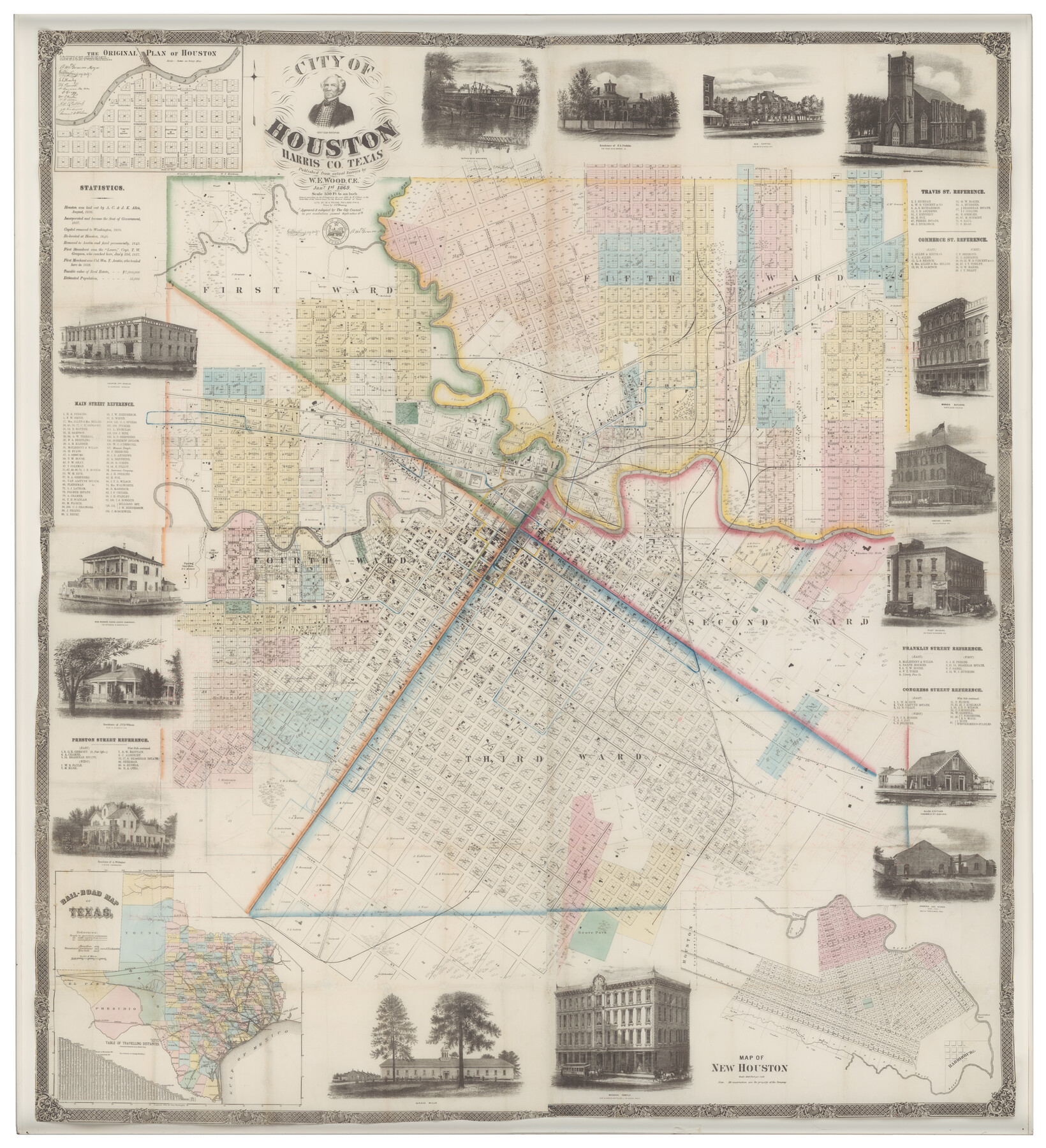
City of Houston
- 
                          Map/Doc
93637
 - 
                            Collection
Non-GLO Digital Images
 - 
                            Object Dates
1869 (Creation Date)
 - 
                            People and Organizations
W.E. Wood (Publisher)
W.H. Rease (Printer)
 - 
                            Subjects
City
 - 
                            Height x Width
44.9 x 40.9 inches
114.1 x 103.9 cm
 - 
                            Medium
digital image
 - 
                            Comments
This map was scanned for the benefit of the Texas State Historical Association courtesy of Mary Jon & J.P. Bryan's "Visions of the West" Collection. Original map is 69.1" x 62.9" but the reproduction is printed at 65% due to printer size limitations.
 
Part of: Non-GLO Digital Images
            A Map of Austin's Colony and adjacent country in Texas drawn principally from actual survey by Stephen F. Austin


            A Map of Austin's Colony and adjacent country in Texas drawn principally from actual survey by Stephen F. Austin
1820
Size 13.8 x 17.0 inches
                                Map/Doc 93353
            
            Plan of the City of Washington the Capitol of the United States of America


                                            Print $20.00                    
                                             -                         Digital $50.00                                    
                Plan of the City of Washington the Capitol of the United States of America
1863
Size 12.7 x 15.8 inches
                                Map/Doc 94475
            
            Bird's Eye View of the City of Brenham, Washington County, Texas


                                            Print $20.00                    
                                    
                Bird's Eye View of the City of Brenham, Washington County, Texas
1881
Size 19.4 x 26.7 inches
                                Map/Doc 89076
            
            The Rand-McNally New Commercial Atlas Map of Texas


                                            Print $20.00                    
                                    
                The Rand-McNally New Commercial Atlas Map of Texas
1914
Size 28.6 x 42.4 inches
                                Map/Doc 78225
            
            [Movements & Objectives of the 143rd & 144th Infantry and many other divisions and regiments, 1918]


                                            Print $40.00                    
                                    
                [Movements & Objectives of the 143rd & 144th Infantry and many other divisions and regiments, 1918]
1918
Size 64.2 x 37.5 inches
                                Map/Doc 94138
            
            Ladonia, Fannin County, Texas


                                            Print $20.00                    
                                    
                Ladonia, Fannin County, Texas
1891
Size 12.0 x 22.1 inches
                                Map/Doc 89097
            
            Bird's Eye View of Jefferson, Texas


                                            Print $20.00                    
                                    
                Bird's Eye View of Jefferson, Texas
1872
Size 18.7 x 23.5 inches
                                Map/Doc 89095
            
            [WWI Topographic Planning Map of the Ardennes department] - Verso


                                            Print $20.00                    
                                    
                [WWI Topographic Planning Map of the Ardennes department] - Verso
1918
Size 35.9 x 20.4 inches
                                Map/Doc 94130
            You may also like
            [River Secs. 55-79, Archer County School Land League 3 and surrounding surveys]


                                            Print $20.00                    
                                             -                         Digital $50.00                                    
                [River Secs. 55-79, Archer County School Land League 3 and surrounding surveys]
Size 28.3 x 20.4 inches
                                Map/Doc 90472
            
            Harris County Working Sketch 118


                                            Print $20.00                    
                                             -                         Digital $50.00                                    
                Harris County Working Sketch 118
1984
Size 24.1 x 34.8 inches
                                Map/Doc 66010
            
            Kerr County Boundary File 2


                                            Print $46.00                    
                                             -                         Digital $50.00                                    
                Kerr County Boundary File 2
Size 15.6 x 26.5 inches
                                Map/Doc 55984
            
            Floyd County Boundary File 2b


                                            Print $40.00                    
                                             -                         Digital $50.00                                    
                Floyd County Boundary File 2b
Size 38.9 x 20.1 inches
                                Map/Doc 53490
            
            Upshur County Working Sketch 10


                                            Print $20.00                    
                                             -                         Digital $50.00                                    
                Upshur County Working Sketch 10
1969
Size 42.1 x 37.0 inches
                                Map/Doc 69566
            
            Titus County Boundary File 2


                                            Print $6.00                    
                                             -                         Digital $50.00                                    
                Titus County Boundary File 2
Size 7.7 x 6.7 inches
                                Map/Doc 59297
            
            Map of Texas Containing the Latest Grants and Discoveries


                                            Print $20.00                    
                                    
                Map of Texas Containing the Latest Grants and Discoveries
1836
Size 16.2 x 10.6 inches
                                Map/Doc 76245
            
            Jasper County


                                            Print $20.00                    
                                             -                         Digital $50.00                                    
                Jasper County
1882
Size 17.6 x 14.0 inches
                                Map/Doc 75779
            
            Lynn County Boundary File 6


                                            Print $4.00                    
                                             -                         Digital $50.00                                    
                Lynn County Boundary File 6
Size 10.9 x 8.8 inches
                                Map/Doc 56639
            
            Bexar County Sketch File 47


                                            Print $40.00                    
                                             -                         Digital $50.00                                    
                Bexar County Sketch File 47
1896
Size 9.9 x 19.6 inches
                                Map/Doc 10925
            
            Loving County Working Sketch 11


                                            Print $40.00                    
                                             -                         Digital $50.00                                    
                Loving County Working Sketch 11
1957
Size 21.2 x 120.7 inches
                                Map/Doc 70643
            
            Nueces County Working Sketch 2


                                            Print $20.00                    
                                             -                         Digital $50.00                                    
                Nueces County Working Sketch 2
1950
Size 42.0 x 15.5 inches
                                Map/Doc 71304