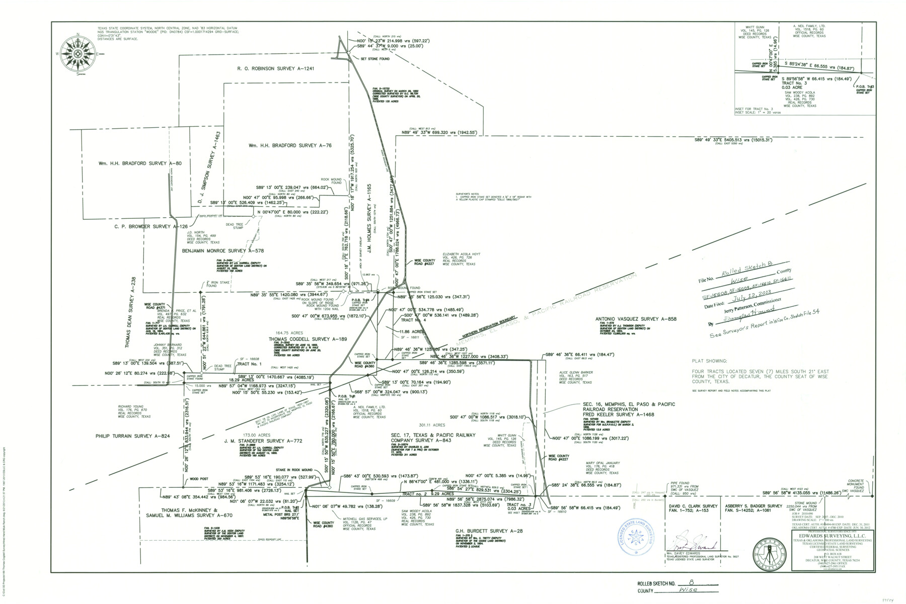
Wise County Rolled Sketch 8
Plat showing four tracts [SF-16608, SF-16609, SF-16610, and SF-16611] located southeast from the City of Decatur
-
Map/Doc
93554
-
Collection
General Map Collection
-
Object Dates
2010 (Survey Date)
2013/7/12 (File Date)
-
People and Organizations
Wm. Davey Edwards, PhD (Surveyor/Engineer)
-
Counties
Wise
-
Subjects
Surveying Rolled Sketch
-
Height x Width
24.0 x 36.0 inches
61.0 x 91.4 cm
-
Medium
mylar, print
-
Scale
1" = 200 varas
-
Comments
See Wise County Sketch File 54 (93553) for report.
Related maps
Wise County Sketch File 54

Print $22.00
- Digital $50.00
Wise County Sketch File 54
2012
Size 11.0 x 8.5 inches
Map/Doc 93553
Part of: General Map Collection
Map of the City of Corsicana (Navarro County) Texas

Print $40.00
- Digital $50.00
Map of the City of Corsicana (Navarro County) Texas
1963
Size 43.2 x 92.3 inches
Map/Doc 93673
Webb County Sketch File 18

Print $20.00
- Digital $50.00
Webb County Sketch File 18
1886
Size 19.9 x 17.7 inches
Map/Doc 12637
Robertson County Working Sketch 18

Print $20.00
- Digital $50.00
Robertson County Working Sketch 18
1995
Size 29.9 x 34.1 inches
Map/Doc 63591
Lavaca County Rolled Sketch 3

Print $20.00
- Digital $50.00
Lavaca County Rolled Sketch 3
1959
Size 42.8 x 32.8 inches
Map/Doc 9419
Flight Mission No. DIX-6P, Frame 128, Aransas County

Print $20.00
- Digital $50.00
Flight Mission No. DIX-6P, Frame 128, Aransas County
1956
Size 19.2 x 22.6 inches
Map/Doc 83834
Trinity County Sketch File 13

Print $6.00
- Digital $50.00
Trinity County Sketch File 13
1857
Size 5.0 x 6.3 inches
Map/Doc 38537
Liberty County Working Sketch 74

Print $20.00
- Digital $50.00
Liberty County Working Sketch 74
1979
Size 38.8 x 35.4 inches
Map/Doc 70534
Kent County Boundary File 4a

Print $18.00
- Digital $50.00
Kent County Boundary File 4a
Size 14.2 x 8.5 inches
Map/Doc 55838
McMullen County Working Sketch 41

Print $20.00
- Digital $50.00
McMullen County Working Sketch 41
1978
Size 32.5 x 23.9 inches
Map/Doc 70742
Connected Map of Austin's Colony

Print $20.00
- Digital $50.00
Connected Map of Austin's Colony
1892
Size 47.1 x 42.8 inches
Map/Doc 76073
Andrews County Working Sketch 15

Print $40.00
- Digital $50.00
Andrews County Working Sketch 15
1957
Size 50.5 x 36.1 inches
Map/Doc 67061
Highland Lakes 1981 in the scenic Hill Country of Central Texas

Digital $50.00
Highland Lakes 1981 in the scenic Hill Country of Central Texas
1981
Size 11.3 x 16.8 inches
Map/Doc 94174
You may also like
Swisher County Sketch File 2

Print $8.00
- Digital $50.00
Swisher County Sketch File 2
1891
Size 14.3 x 8.6 inches
Map/Doc 37574
General Highway Map, Kent County, Texas

Print $20.00
General Highway Map, Kent County, Texas
1940
Size 18.4 x 24.9 inches
Map/Doc 79156
Pecos County Working Sketch 55

Print $20.00
- Digital $50.00
Pecos County Working Sketch 55
1948
Size 38.4 x 27.7 inches
Map/Doc 71527
Wood County Working Sketch 17

Print $20.00
- Digital $50.00
Wood County Working Sketch 17
Size 24.0 x 31.3 inches
Map/Doc 62017
Topographical Map of the Rio Grande, Sheet No. 20

Print $20.00
- Digital $50.00
Topographical Map of the Rio Grande, Sheet No. 20
1912
Map/Doc 89544
Plan of the City of Indianola, Texas

Print $40.00
- Digital $50.00
Plan of the City of Indianola, Texas
1868
Size 37.5 x 55.3 inches
Map/Doc 4835
Lynn County Sketch File 20

Print $4.00
- Digital $50.00
Lynn County Sketch File 20
1891
Size 8.8 x 10.9 inches
Map/Doc 30527
Map of Texas with population and location of principal towns and cities according to latest reliable statistics

Print $20.00
- Digital $50.00
Map of Texas with population and location of principal towns and cities according to latest reliable statistics
1911
Size 19.4 x 21.5 inches
Map/Doc 95875
Flight Mission No. DAG-24K, Frame 37, Matagorda County

Print $20.00
- Digital $50.00
Flight Mission No. DAG-24K, Frame 37, Matagorda County
1953
Size 18.5 x 22.2 inches
Map/Doc 86524
Kleberg County Rolled Sketch 10-29

Print $20.00
- Digital $50.00
Kleberg County Rolled Sketch 10-29
1952
Size 37.6 x 33.8 inches
Map/Doc 9373
Limestone County Sketch File 10b

Print $22.00
- Digital $50.00
Limestone County Sketch File 10b
1875
Size 15.0 x 14.1 inches
Map/Doc 30175
Galveston County Rolled Sketch 18

Print $20.00
- Digital $50.00
Galveston County Rolled Sketch 18
1959
Size 27.9 x 35.8 inches
Map/Doc 5955