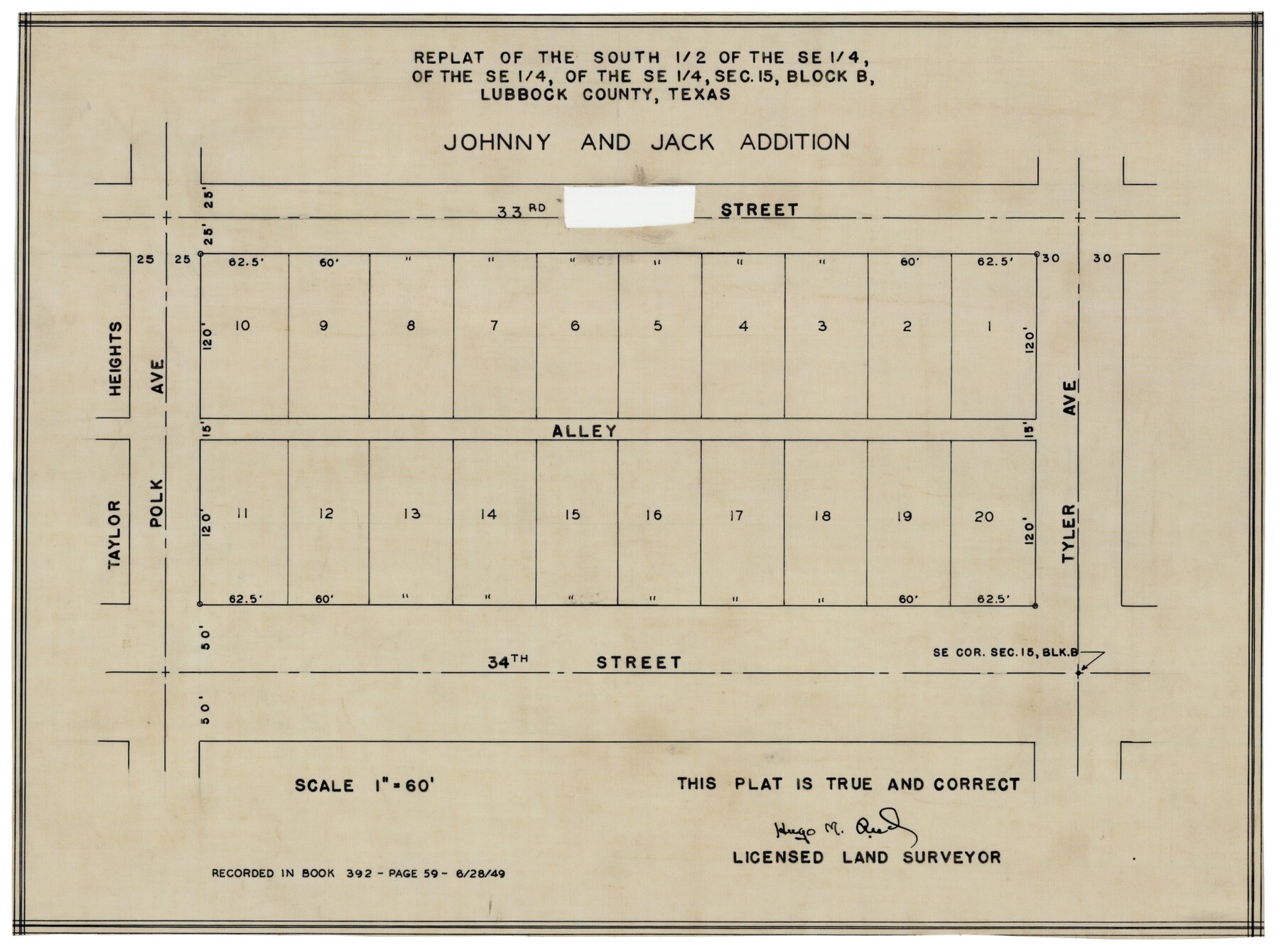
Replat of the South Half of the SE 1/4 of the SE 1/4 of the SE 1/4, Sec. 15, Block B, Johnny and Jack Edition
-
Map/Doc
92793
-
Collection
Twichell Survey Records
-
Object Dates
6/28/1949 (Creation Date)
-
People and Organizations
Hugo M. Reed (Surveyor/Engineer)
-
Counties
Lubbock
-
Height x Width
15.6 x 11.6 inches
39.6 x 29.5 cm
Part of: Twichell Survey Records
[Texas Boundary Line]
![92077, [Texas Boundary Line], Twichell Survey Records](https://historictexasmaps.com/wmedia_w700/maps/92077-1.tif.jpg)
Print $20.00
- Digital $50.00
[Texas Boundary Line]
Size 21.2 x 12.0 inches
Map/Doc 92077
J. W. Kendrick Land, Crosby County, Texas

Print $20.00
- Digital $50.00
J. W. Kendrick Land, Crosby County, Texas
Size 43.1 x 33.8 inches
Map/Doc 92604
[In Northwest 1/4 of County in the vicinity of the John Walker Survey]
![90910, [In Northwest 1/4 of County in the vicinity of the John Walker Survey], Twichell Survey Records](https://historictexasmaps.com/wmedia_w700/maps/90910-1.tif.jpg)
Print $20.00
- Digital $50.00
[In Northwest 1/4 of County in the vicinity of the John Walker Survey]
Size 15.2 x 23.9 inches
Map/Doc 90910
Survey of Blocks 1, 2, 3, 4, 5, Merritt and Wild Addition

Print $20.00
- Digital $50.00
Survey of Blocks 1, 2, 3, 4, 5, Merritt and Wild Addition
1955
Size 23.5 x 18.3 inches
Map/Doc 92727
[Blocks 2, M3, M20, G. & M. Block 22 and others in the vicinity]
![91803, [Blocks 2, M3, M20, G. & M. Block 22 and others in the vicinity], Twichell Survey Records](https://historictexasmaps.com/wmedia_w700/maps/91803-1.tif.jpg)
Print $20.00
- Digital $50.00
[Blocks 2, M3, M20, G. & M. Block 22 and others in the vicinity]
Size 19.0 x 23.2 inches
Map/Doc 91803
Sketch Showing Block 142, Original Town, Survey 1, Block O

Print $20.00
- Digital $50.00
Sketch Showing Block 142, Original Town, Survey 1, Block O
Size 23.0 x 18.0 inches
Map/Doc 92782
[Capitol Leagues 661-729]
![92979, [Capitol Leagues 661-729], Twichell Survey Records](https://historictexasmaps.com/wmedia_w700/maps/92979-1.tif.jpg)
Print $20.00
- Digital $50.00
[Capitol Leagues 661-729]
Size 24.2 x 24.9 inches
Map/Doc 92979
Willie Winn Tract

Print $2.00
- Digital $50.00
Willie Winn Tract
1903
Size 5.9 x 7.6 inches
Map/Doc 92285
Rhyne Simpson Addition City of Lubbock Section 3, Block O

Print $20.00
- Digital $50.00
Rhyne Simpson Addition City of Lubbock Section 3, Block O
1951
Size 18.2 x 23.4 inches
Map/Doc 92845
[T. & N. O. Railroad Company Blocks 2T and 3T]
![91489, [T. & N. O. Railroad Company Blocks 2T and 3T], Twichell Survey Records](https://historictexasmaps.com/wmedia_w700/maps/91489-1.tif.jpg)
Print $20.00
- Digital $50.00
[T. & N. O. Railroad Company Blocks 2T and 3T]
Size 24.4 x 8.8 inches
Map/Doc 91489
The California Case

Print $3.00
- Digital $50.00
The California Case
Size 15.8 x 9.5 inches
Map/Doc 91695
[Southeast Portion of Motley County]
![91508, [Southeast Portion of Motley County], Twichell Survey Records](https://historictexasmaps.com/wmedia_w700/maps/91508-1.tif.jpg)
Print $20.00
- Digital $50.00
[Southeast Portion of Motley County]
Size 31.2 x 34.3 inches
Map/Doc 91508
You may also like
[University Lands Block 16 and Blocks 194, Z and part of 12]
![91618, [University Lands Block 16 and Blocks 194, Z and part of 12], Twichell Survey Records](https://historictexasmaps.com/wmedia_w700/maps/91618-1.tif.jpg)
Print $20.00
- Digital $50.00
[University Lands Block 16 and Blocks 194, Z and part of 12]
1911
Size 32.2 x 23.3 inches
Map/Doc 91618
Reagan County Sketch File 2A

Print $6.00
- Digital $50.00
Reagan County Sketch File 2A
1882
Size 9.1 x 17.6 inches
Map/Doc 12211
Young County Sketch File 17

Print $20.00
- Digital $50.00
Young County Sketch File 17
Size 18.5 x 24.3 inches
Map/Doc 12713
Upshur County Sketch File 11

Print $22.00
- Digital $50.00
Upshur County Sketch File 11
Size 8.4 x 10.4 inches
Map/Doc 38750
Matagorda County Working Sketch 26

Print $20.00
- Digital $50.00
Matagorda County Working Sketch 26
1979
Size 14.1 x 19.5 inches
Map/Doc 70884
Bee County Sketch File 34

Print $14.00
Bee County Sketch File 34
2022
Size 11.0 x 8.5 inches
Map/Doc 97030
Mason County Sketch File 4

Print $6.00
- Digital $50.00
Mason County Sketch File 4
1875
Size 12.9 x 8.0 inches
Map/Doc 30684
General Highway Map, Willacy County, Texas

Print $20.00
General Highway Map, Willacy County, Texas
1940
Size 18.5 x 24.8 inches
Map/Doc 79279
Sutton County Working Sketch 33

Print $20.00
- Digital $50.00
Sutton County Working Sketch 33
1936
Size 23.3 x 32.2 inches
Map/Doc 62376
Flight Mission No. BRE-2P, Frame 25, Nueces County

Print $20.00
- Digital $50.00
Flight Mission No. BRE-2P, Frame 25, Nueces County
1956
Size 18.4 x 22.2 inches
Map/Doc 86734
Bee County Sketch File 30

Print $6.00
- Digital $50.00
Bee County Sketch File 30
Size 14.2 x 8.9 inches
Map/Doc 14341
Floyd County Sketch File 1

Print $5.00
- Digital $50.00
Floyd County Sketch File 1
Size 11.0 x 17.0 inches
Map/Doc 22688