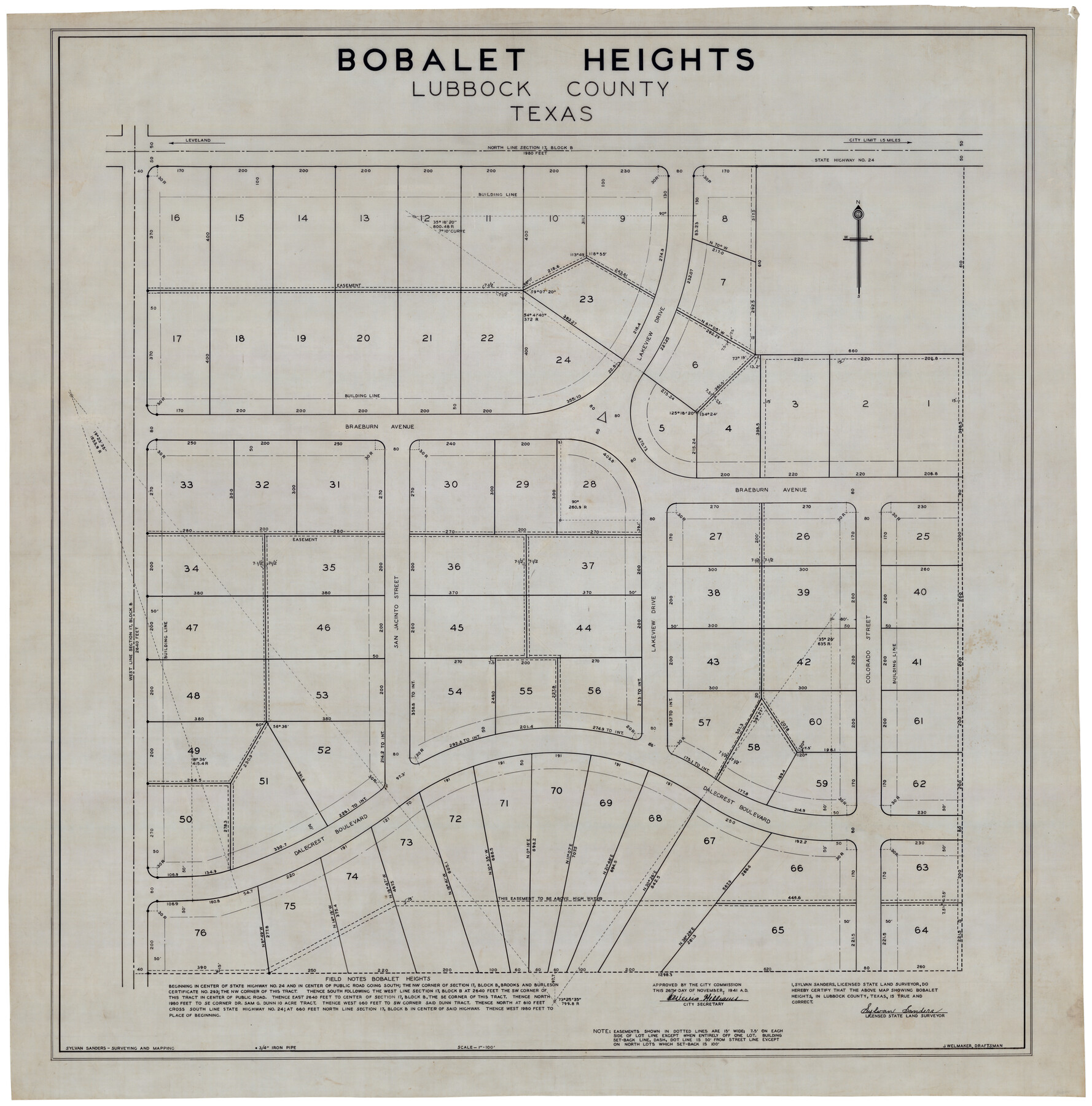
Bobalet Heights
-
Map/Doc
92787
-
Collection
Twichell Survey Records
-
Object Dates
11/26/1941 (Creation Date)
-
People and Organizations
J. Welmaker (Draftsman)
Sylvan Sanders (Surveyor/Engineer)
-
Counties
Lubbock
-
Height x Width
35.6 x 36.5 inches
90.4 x 92.7 cm
-
Medium
brownline
-
Scale
100 feet
Part of: Twichell Survey Records
[Leagues 27, 28, 69, 70, 71, 72, and 73]
![91096, [Leagues 27, 28, 69, 70, 71, 72, and 73], Twichell Survey Records](https://historictexasmaps.com/wmedia_w700/maps/91096-1.tif.jpg)
Print $20.00
- Digital $50.00
[Leagues 27, 28, 69, 70, 71, 72, and 73]
Size 24.0 x 15.7 inches
Map/Doc 91096
[W. T. Brewer: M. McDonald, Ralph Gilpin, A. Vanhooser, John Baker, John R. Taylor Surveys]
![90962, [W. T. Brewer: M. McDonald, Ralph Gilpin, A. Vanhooser, John Baker, John R. Taylor Surveys], Twichell Survey Records](https://historictexasmaps.com/wmedia_w700/maps/90962-1.tif.jpg)
Print $2.00
- Digital $50.00
[W. T. Brewer: M. McDonald, Ralph Gilpin, A. Vanhooser, John Baker, John R. Taylor Surveys]
Size 9.2 x 11.4 inches
Map/Doc 90962
Public School Land Leagues 1 through 63]
![92487, Public School Land Leagues 1 through 63], Twichell Survey Records](https://historictexasmaps.com/wmedia_w700/maps/92487-1.tif.jpg)
Print $20.00
- Digital $50.00
Public School Land Leagues 1 through 63]
Size 23.9 x 16.8 inches
Map/Doc 92487
[Sketch Showing Blocks O18, P Mc, B10 and B11]
![93105, [Sketch Showing Blocks O18, P Mc, B10 and B11], Twichell Survey Records](https://historictexasmaps.com/wmedia_w700/maps/93105-1.tif.jpg)
Print $3.00
- Digital $50.00
[Sketch Showing Blocks O18, P Mc, B10 and B11]
Size 11.1 x 11.1 inches
Map/Doc 93105
Lofland Subdivision, 2nd Installment, North Part of NW Quarter Section 72, Block A

Print $20.00
- Digital $50.00
Lofland Subdivision, 2nd Installment, North Part of NW Quarter Section 72, Block A
Size 34.7 x 19.0 inches
Map/Doc 92763
[Sketch showing Potter County Block 2] / [Sketch showing F. W. & D. C. Round House]
![91709, [Sketch showing Potter County Block 2] / [Sketch showing F. W. & D. C. Round House], Twichell Survey Records](https://historictexasmaps.com/wmedia_w700/maps/91709-1.tif.jpg)
Print $20.00
- Digital $50.00
[Sketch showing Potter County Block 2] / [Sketch showing F. W. & D. C. Round House]
Size 12.2 x 14.6 inches
Map/Doc 91709
Lyons Subdivision North Part Block 79

Print $20.00
- Digital $50.00
Lyons Subdivision North Part Block 79
Size 19.6 x 24.5 inches
Map/Doc 92795
Plat Compiled by W.J. Williams, Plainview, Texas, and Sylvan Sanders, Lubbock, Texas Showing Position of Original and Re-Survey Corners in Lynn, Terry, Yoakum, Gaines, and Dawson Counties, Texas

Print $40.00
- Digital $50.00
Plat Compiled by W.J. Williams, Plainview, Texas, and Sylvan Sanders, Lubbock, Texas Showing Position of Original and Re-Survey Corners in Lynn, Terry, Yoakum, Gaines, and Dawson Counties, Texas
1946
Size 56.6 x 22.6 inches
Map/Doc 89628
[Plat showing 1.0 acre of land out of the NE/4 of Section 2, Block E]
![92706, [Plat showing 1.0 acre of land out of the NE/4 of Section 2, Block E], Twichell Survey Records](https://historictexasmaps.com/wmedia_w700/maps/92706-1.tif.jpg)
Print $3.00
- Digital $50.00
[Plat showing 1.0 acre of land out of the NE/4 of Section 2, Block E]
1954
Size 9.6 x 10.2 inches
Map/Doc 92706
[H. & T. C. Block 47 and Vicinity]
![91423, [H. & T. C. Block 47 and Vicinity], Twichell Survey Records](https://historictexasmaps.com/wmedia_w700/maps/91423-1.tif.jpg)
Print $20.00
- Digital $50.00
[H. & T. C. Block 47 and Vicinity]
1887
Size 16.3 x 18.8 inches
Map/Doc 91423
Gulf Coast Oil Fields

Print $2.00
- Digital $50.00
Gulf Coast Oil Fields
Size 12.6 x 8.1 inches
Map/Doc 90135
Sheet 5 copied from Peck Book 6 [Strip Map showing T. & P. connecting lines]
![93171, Sheet 5 copied from Peck Book 6 [Strip Map showing T. & P. connecting lines], Twichell Survey Records](https://historictexasmaps.com/wmedia_w700/maps/93171-1.tif.jpg)
Print $40.00
- Digital $50.00
Sheet 5 copied from Peck Book 6 [Strip Map showing T. & P. connecting lines]
1909
Size 7.0 x 70.7 inches
Map/Doc 93171
You may also like
DeWitt County Sketch File 5

Print $4.00
- Digital $50.00
DeWitt County Sketch File 5
1872
Size 13.0 x 8.3 inches
Map/Doc 20803
Presidio County Working Sketch 126

Print $20.00
- Digital $50.00
Presidio County Working Sketch 126
1987
Size 36.9 x 46.5 inches
Map/Doc 71804
Victoria County Sketch File V1

Print $10.00
- Digital $50.00
Victoria County Sketch File V1
1896
Size 14.6 x 9.2 inches
Map/Doc 39525
Pecos County Rolled Sketch 142

Print $20.00
- Digital $50.00
Pecos County Rolled Sketch 142
Size 26.9 x 41.9 inches
Map/Doc 7276
Crockett County Rolled Sketch 3

Print $20.00
- Digital $50.00
Crockett County Rolled Sketch 3
1886
Size 18.1 x 22.9 inches
Map/Doc 5579
South Part Pecos County

Print $20.00
- Digital $50.00
South Part Pecos County
1976
Size 36.8 x 44.2 inches
Map/Doc 73262
Nolan County Working Sketch 5

Print $3.00
- Digital $50.00
Nolan County Working Sketch 5
1950
Size 9.7 x 13.9 inches
Map/Doc 71296
Fort Bend County Boundary File 4

Print $40.00
- Digital $50.00
Fort Bend County Boundary File 4
Size 18.5 x 26.2 inches
Map/Doc 53567
Topographical Map of the Rio Grande, Sheet No. 28

Print $20.00
- Digital $50.00
Topographical Map of the Rio Grande, Sheet No. 28
1912
Map/Doc 89552
Delta County Working Sketch 2

Print $20.00
- Digital $50.00
Delta County Working Sketch 2
1963
Size 26.6 x 25.2 inches
Map/Doc 68639
Nueces County Rolled Sketch 34

Print $20.00
- Digital $50.00
Nueces County Rolled Sketch 34
1951
Size 47.9 x 37.5 inches
Map/Doc 9601
Lavaca County Sketch File 4

Print $6.00
- Digital $50.00
Lavaca County Sketch File 4
Size 8.2 x 15.3 inches
Map/Doc 29636