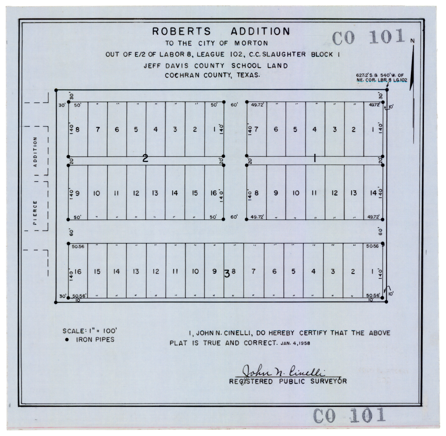
Roberts Addition to the City of Morton
CO101
- 
                          Map/Doc
92540
 - 
                            Collection
Twichell Survey Records
 - 
                            Object Dates
1/4/1958 (Creation Date)
 - 
                            People and Organizations
John N. Cinelli (Surveyor/Engineer)
 - 
                            Counties
Cochran
 - 
                            Height x Width
11.8 x 11.4 inches
30.0 x 29.0 cm
 
Part of: Twichell Survey Records
            [Blocks D and P]


                                            Print $20.00                    
                                             -                         Digital $50.00                                    
                [Blocks D and P]
Size 41.8 x 29.1 inches
                                Map/Doc 92490
            
            [Canadian River and surveys north]


                                            Print $20.00                    
                                             -                         Digital $50.00                                    
                [Canadian River and surveys north]
Size 38.3 x 21.6 inches
                                Map/Doc 91780
            
            University of Texas System University Lands


                                            Print $20.00                    
                                             -                         Digital $50.00                                    
                University of Texas System University Lands
1937
Size 23.3 x 17.6 inches
                                Map/Doc 93237
            
            [T. & P. Block U and H. & T. C. Block 1]


                                            Print $20.00                    
                                             -                         Digital $50.00                                    
                [T. & P. Block U and H. & T. C. Block 1]
Size 20.5 x 16.7 inches
                                Map/Doc 91871
            
            [County lines and corners]


                                            Print $20.00                    
                                             -                         Digital $50.00                                    
                [County lines and corners]
Size 22.8 x 17.8 inches
                                Map/Doc 90801
            
            Sketch showing recent surveys of State School Land adjoining Capitol Leagues No. 357 1/2, 367, 373 and 374 corrected out of conflict


                                            Print $2.00                    
                                             -                         Digital $50.00                                    
                Sketch showing recent surveys of State School Land adjoining Capitol Leagues No. 357 1/2, 367, 373 and 374 corrected out of conflict
1905
Size 7.3 x 10.4 inches
                                Map/Doc 90535
            
            [H. E. & W. T. Block 9, L. S. & V. Block 1, Public School Land Block C-40, Portion of Block H]


                                            Print $20.00                    
                                             -                         Digital $50.00                                    
                [H. E. & W. T. Block 9, L. S. & V. Block 1, Public School Land Block C-40, Portion of Block H]
Size 27.0 x 33.3 inches
                                Map/Doc 91354
            
            Grimes Estate Lands, Cochran County, Texas


                                            Print $20.00                    
                                             -                         Digital $50.00                                    
                Grimes Estate Lands, Cochran County, Texas
Size 25.6 x 21.6 inches
                                Map/Doc 92520
            
            [Blocks C4, SI, and JK]


                                            Print $20.00                    
                                             -                         Digital $50.00                                    
                [Blocks C4, SI, and JK]
Size 15.0 x 13.3 inches
                                Map/Doc 90778
            
            [Township 5 North, Blocks 33 and 34]


                                            Print $20.00                    
                                             -                         Digital $50.00                                    
                [Township 5 North, Blocks 33 and 34]
Size 26.3 x 18.7 inches
                                Map/Doc 92568
            
            [I. G. Yates survey and adjacent area south of Runnels County School Land]


                                            Print $20.00                    
                                             -                         Digital $50.00                                    
                [I. G. Yates survey and adjacent area south of Runnels County School Land]
Size 15.1 x 14.5 inches
                                Map/Doc 91679
            
            [Sketch showing the southwest part of the Glidden and Sanborn Addition]


                                            Print $20.00                    
                                             -                         Digital $50.00                                    
                [Sketch showing the southwest part of the Glidden and Sanborn Addition]
Size 20.0 x 29.3 inches
                                Map/Doc 91746
            You may also like
            Flight Mission No. BRE-2P, Frame 72, Nueces County


                                            Print $20.00                    
                                             -                         Digital $50.00                                    
                Flight Mission No. BRE-2P, Frame 72, Nueces County
1956
Size 18.5 x 22.2 inches
                                Map/Doc 86767
            
            Zapata County Rolled Sketch 12B


                                            Print $40.00                    
                                             -                         Digital $50.00                                    
                Zapata County Rolled Sketch 12B
1917
Size 55.7 x 40.0 inches
                                Map/Doc 10166
            
            [Map of Val Verde County]


                                            Print $20.00                    
                                             -                         Digital $50.00                                    
                [Map of Val Verde County]
1931
Size 36.4 x 24.1 inches
                                Map/Doc 4110
            
            Bell County Sketch File 1


                                            Print $40.00                    
                                             -                         Digital $50.00                                    
                Bell County Sketch File 1
1847
Size 14.7 x 12.4 inches
                                Map/Doc 14365
            
            Galveston County Rolled Sketch 39


                                            Print $20.00                    
                                             -                         Digital $50.00                                    
                Galveston County Rolled Sketch 39
Size 18.1 x 21.5 inches
                                Map/Doc 45207
            
            Starr County Sketch File 38


                                            Print $8.00                    
                                             -                         Digital $50.00                                    
                Starr County Sketch File 38
1940
Size 14.2 x 8.8 inches
                                Map/Doc 36985
            
            Wood County Rolled Sketch 2


                                            Print $40.00                    
                                             -                         Digital $50.00                                    
                Wood County Rolled Sketch 2
1941
Size 52.6 x 24.9 inches
                                Map/Doc 10160
            
            The Republic County of Colorado. January 29, 1842


                                            Print $20.00                    
                                    
                The Republic County of Colorado. January 29, 1842
2020
Size 18.4 x 21.7 inches
                                Map/Doc 96125
            
            Travis County Working Sketch 42


                                            Print $20.00                    
                                             -                         Digital $50.00                                    
                Travis County Working Sketch 42
1974
Size 32.5 x 35.2 inches
                                Map/Doc 69426
            
            Map of Asia engraved to illustrate Mitchell's new intermediate geography (Inset: Map of Palestine or the Holy Land)


                                            Print $20.00                    
                                             -                         Digital $50.00                                    
                Map of Asia engraved to illustrate Mitchell's new intermediate geography (Inset: Map of Palestine or the Holy Land)
1885
Size 9.0 x 12.2 inches
                                Map/Doc 93529
            
            [Sketch for Mineral Application 21493 - Clay County]


                                            Print $40.00                    
                                             -                         Digital $50.00                                    
                [Sketch for Mineral Application 21493 - Clay County]
Size 63.1 x 35.3 inches
                                Map/Doc 65626