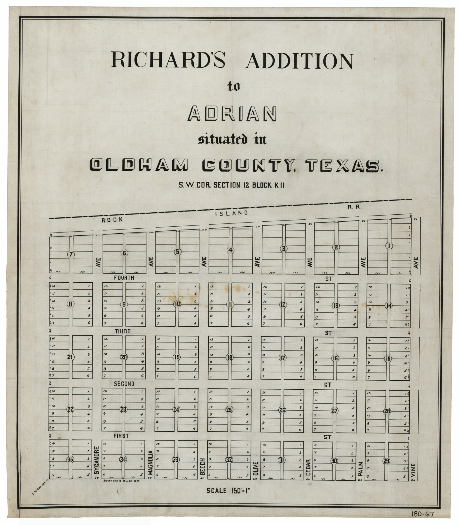
Richard's Addition to Adrian, Situated in Oldham County, Texas
180-67
-
Map/Doc
91428
-
Collection
Twichell Survey Records
-
Counties
Oldham
-
Height x Width
21.4 x 24.3 inches
54.4 x 61.7 cm
Part of: Twichell Survey Records
[Capitol Leagues 217- 235, 238, and 239]
![90706, [Capitol Leagues 217- 235, 238, and 239], Twichell Survey Records](https://historictexasmaps.com/wmedia_w700/maps/90706-1.tif.jpg)
Print $20.00
- Digital $50.00
[Capitol Leagues 217- 235, 238, and 239]
Size 26.3 x 26.9 inches
Map/Doc 90706
Replat of Baker 2nd Addition to Lamesa, Part of Southwest Quarter, Section 71, Block 35, Dawson County, Texas

Print $20.00
- Digital $50.00
Replat of Baker 2nd Addition to Lamesa, Part of Southwest Quarter, Section 71, Block 35, Dawson County, Texas
1958
Size 9.9 x 18.8 inches
Map/Doc 92633
[Blocks JD, B, D10, A2, A3]
![90777, [Blocks JD, B, D10, A2, A3], Twichell Survey Records](https://historictexasmaps.com/wmedia_w700/maps/90777-1.tif.jpg)
Print $2.00
- Digital $50.00
[Blocks JD, B, D10, A2, A3]
Size 7.3 x 13.4 inches
Map/Doc 90777
[Aaron Cherry and A. M. de Lejarza Surveys on the Trinity River]
![91080, [Aaron Cherry and A. M. de Lejarza Surveys on the Trinity River], Twichell Survey Records](https://historictexasmaps.com/wmedia_w700/maps/91080-1.tif.jpg)
Print $20.00
- Digital $50.00
[Aaron Cherry and A. M. de Lejarza Surveys on the Trinity River]
Size 26.3 x 14.1 inches
Map/Doc 91080
[Sketch of Norwood's Homestead]
![89646, [Sketch of Norwood's Homestead], Twichell Survey Records](https://historictexasmaps.com/wmedia_w700/maps/89646-1.tif.jpg)
Print $40.00
- Digital $50.00
[Sketch of Norwood's Homestead]
Size 31.8 x 49.7 inches
Map/Doc 89646
Robertson & Scott V Ranch situated in Crosby County, Texas

Print $40.00
- Digital $50.00
Robertson & Scott V Ranch situated in Crosby County, Texas
Size 42.0 x 50.3 inches
Map/Doc 89753
[North part of G. C. & S. F. Block OP, Runnels County School Land]
![90309, [North part of G. C. & S. F. Block OP, Runnels County School Land], Twichell Survey Records](https://historictexasmaps.com/wmedia_w700/maps/90309-1.tif.jpg)
Print $20.00
- Digital $50.00
[North part of G. C. & S. F. Block OP, Runnels County School Land]
Size 14.3 x 17.6 inches
Map/Doc 90309
[H. & T. C. Block 47]
![91146, [H. & T. C. Block 47], Twichell Survey Records](https://historictexasmaps.com/wmedia_w700/maps/91146-1.tif.jpg)
Print $20.00
- Digital $50.00
[H. & T. C. Block 47]
Size 15.8 x 23.4 inches
Map/Doc 91146
[H. E. & W. T. Block 9, L. S. & V. Block 1, Public School Land Block C-40, Portion of Block H]
![91354, [H. E. & W. T. Block 9, L. S. & V. Block 1, Public School Land Block C-40, Portion of Block H], Twichell Survey Records](https://historictexasmaps.com/wmedia_w700/maps/91354-1.tif.jpg)
Print $20.00
- Digital $50.00
[H. E. & W. T. Block 9, L. S. & V. Block 1, Public School Land Block C-40, Portion of Block H]
Size 27.0 x 33.3 inches
Map/Doc 91354
Sketch T [showing Capitol Reserve]
![89631, Sketch T [showing Capitol Reserve], Twichell Survey Records](https://historictexasmaps.com/wmedia_w700/maps/89631-1.tif.jpg)
Print $40.00
- Digital $50.00
Sketch T [showing Capitol Reserve]
1903
Size 22.0 x 48.9 inches
Map/Doc 89631
[Vicinity of Wilson Strickland Survey]
![91380, [Vicinity of Wilson Strickland Survey], Twichell Survey Records](https://historictexasmaps.com/wmedia_w700/maps/91380-1.tif.jpg)
Print $20.00
- Digital $50.00
[Vicinity of Wilson Strickland Survey]
Size 37.1 x 25.5 inches
Map/Doc 91380
[Blocks M-22, M-25 and vicinity]
![91235, [Blocks M-22, M-25 and vicinity], Twichell Survey Records](https://historictexasmaps.com/wmedia_w700/maps/91235-1.tif.jpg)
Print $20.00
- Digital $50.00
[Blocks M-22, M-25 and vicinity]
Size 27.4 x 25.2 inches
Map/Doc 91235
You may also like
Kerr County Working Sketch 11

Print $20.00
- Digital $50.00
Kerr County Working Sketch 11
1951
Size 30.3 x 29.9 inches
Map/Doc 70042
Floyd County Sketch File 25

Print $14.00
- Digital $50.00
Floyd County Sketch File 25
1912
Size 11.5 x 9.0 inches
Map/Doc 22782
Travis County Sketch File 24

Print $4.00
- Digital $50.00
Travis County Sketch File 24
1876
Size 8.1 x 15.4 inches
Map/Doc 38332
Stephens County Sketch File 28

Print $14.00
- Digital $50.00
Stephens County Sketch File 28
1996
Size 14.2 x 8.6 inches
Map/Doc 37104
Wilbarger County Sketch File 29

Print $18.00
- Digital $50.00
Wilbarger County Sketch File 29
2016
Size 11.0 x 8.5 inches
Map/Doc 95325
Live Oak County Sketch File 4

Print $20.00
- Digital $50.00
Live Oak County Sketch File 4
1858
Size 16.3 x 19.2 inches
Map/Doc 12006
Calhoun County

Print $20.00
- Digital $50.00
Calhoun County
1871
Size 22.4 x 18.3 inches
Map/Doc 888
Gillespie County Rolled Sketch 5

Print $20.00
- Digital $50.00
Gillespie County Rolled Sketch 5
1994
Size 25.7 x 20.6 inches
Map/Doc 6012
A.R. Roessler's Latest Map of the State of Texas Exhibiting Mineral and Agricultural Districts, Post Offices and Mailroutes, Railroads projected and finished, Timber, Prairie, Swamp Lands, etc. etc. etc.

Print $20.00
A.R. Roessler's Latest Map of the State of Texas Exhibiting Mineral and Agricultural Districts, Post Offices and Mailroutes, Railroads projected and finished, Timber, Prairie, Swamp Lands, etc. etc. etc.
1874
Size 39.7 x 46.8 inches
Map/Doc 76254
[Surveys in Power and Hewetson's Colony along the Blanco and Medina Rivers]
![46, [Surveys in Power and Hewetson's Colony along the Blanco and Medina Rivers], General Map Collection](https://historictexasmaps.com/wmedia_w700/maps/46.tif.jpg)
Print $20.00
- Digital $50.00
[Surveys in Power and Hewetson's Colony along the Blanco and Medina Rivers]
1834
Size 37.0 x 29.9 inches
Map/Doc 46
Webb County Rolled Sketch 48

Print $20.00
- Digital $50.00
Webb County Rolled Sketch 48
1943
Size 20.1 x 37.3 inches
Map/Doc 8204
Sketches Accompanying Report of Coast Survey for 1851

Digital $50.00
Sketches Accompanying Report of Coast Survey for 1851
Map/Doc 2475