Starr County Sketch File 40
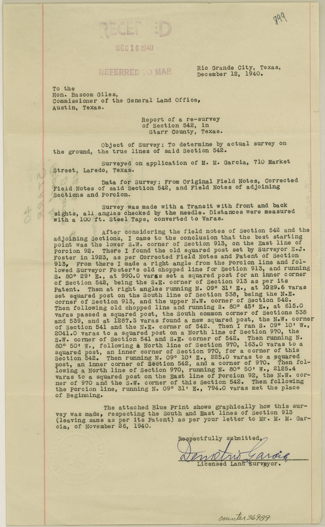
[Report of a resurvey of section 542]
-
Map/Doc
36989
-
Collection
General Map Collection
-
Object Dates
12/12/1940 (Creation Date)
12/16/1940 (File Date)
-
People and Organizations
Demetrio Garcia (Surveyor/Engineer)
-
Counties
Starr
-
Subjects
Surveying Sketch File
-
Height x Width
14.2 x 8.8 inches
36.1 x 22.4 cm
-
Medium
paper, print
-
Comments
See Starr County Sketch File 39 (12339) for sketch.
Related maps
Starr County Sketch File 39

Print $20.00
- Digital $50.00
Starr County Sketch File 39
1940
Size 22.9 x 22.1 inches
Map/Doc 12339
Part of: General Map Collection
Sabine Pass and mouth of the River Sabine in the sea

Print $20.00
- Digital $50.00
Sabine Pass and mouth of the River Sabine in the sea
1840
Size 22.5 x 18.4 inches
Map/Doc 65382
Comanche County Working Sketch 12

Print $20.00
- Digital $50.00
Comanche County Working Sketch 12
1957
Size 15.4 x 25.5 inches
Map/Doc 68146
Lavaca County Sketch File 8

Print $6.00
- Digital $50.00
Lavaca County Sketch File 8
1882
Size 10.7 x 10.3 inches
Map/Doc 29644
Flight Mission No. DQO-2K, Frame 137, Galveston County

Print $20.00
- Digital $50.00
Flight Mission No. DQO-2K, Frame 137, Galveston County
1952
Size 18.8 x 22.5 inches
Map/Doc 85034
San Jacinto County Working Sketch Graphic Index

Print $20.00
- Digital $50.00
San Jacinto County Working Sketch Graphic Index
1942
Size 44.9 x 40.6 inches
Map/Doc 76691
Flight Mission No. DCL-6C, Frame 79, Kenedy County

Print $20.00
- Digital $50.00
Flight Mission No. DCL-6C, Frame 79, Kenedy County
1943
Size 18.6 x 22.4 inches
Map/Doc 85921
Wood County Sketch File 13

Print $24.00
- Digital $50.00
Wood County Sketch File 13
1866
Size 12.5 x 7.6 inches
Map/Doc 40668
DeWitt County Boundary File 25 1/2

Print $34.00
- Digital $50.00
DeWitt County Boundary File 25 1/2
Size 8.5 x 4.0 inches
Map/Doc 52522
Flight Mission No. DQN-1K, Frame 69, Calhoun County

Print $20.00
- Digital $50.00
Flight Mission No. DQN-1K, Frame 69, Calhoun County
1953
Size 18.5 x 22.2 inches
Map/Doc 84156
Rockwall County Boundary File 52a

Print $22.00
- Digital $50.00
Rockwall County Boundary File 52a
Size 12.9 x 8.3 inches
Map/Doc 58461
Matagorda Light to Aransas Pass

Print $20.00
- Digital $50.00
Matagorda Light to Aransas Pass
1924
Size 35.9 x 44.6 inches
Map/Doc 73391
Concho County Working Sketch 10

Print $20.00
- Digital $50.00
Concho County Working Sketch 10
1951
Size 21.2 x 15.6 inches
Map/Doc 68192
You may also like
Dimmit County Rolled Sketch 22A

Print $20.00
- Digital $50.00
Dimmit County Rolled Sketch 22A
2012
Size 23.2 x 34.0 inches
Map/Doc 93630
Jeff Davis County Sketch File 27

Print $20.00
- Digital $50.00
Jeff Davis County Sketch File 27
1915
Size 18.8 x 25.5 inches
Map/Doc 11862
Brewster County Rolled Sketch 20

Print $20.00
- Digital $50.00
Brewster County Rolled Sketch 20
Size 31.4 x 28.2 inches
Map/Doc 5199
Hutchinson County Sketch File 30

Print $6.00
- Digital $50.00
Hutchinson County Sketch File 30
1927
Size 11.2 x 8.8 inches
Map/Doc 27264
Baylor County Boundary File 11

Print $26.00
- Digital $50.00
Baylor County Boundary File 11
Size 11.1 x 8.7 inches
Map/Doc 50419
Flight Mission No. DIX-8P, Frame 73, Aransas County

Print $20.00
- Digital $50.00
Flight Mission No. DIX-8P, Frame 73, Aransas County
1956
Size 18.7 x 22.3 inches
Map/Doc 83904
Hamilton County Working Sketch 36

Print $40.00
- Digital $50.00
Hamilton County Working Sketch 36
2008
Size 36.9 x 57.3 inches
Map/Doc 88996
Travis County Working Sketch 38

Print $20.00
- Digital $50.00
Travis County Working Sketch 38
1974
Size 17.5 x 34.8 inches
Map/Doc 69422
Spanish and Mexican Land Grants in Texas

Print $20.00
Spanish and Mexican Land Grants in Texas
2015
Size 34.0 x 44.0 inches
Map/Doc 93755
The Republic County of Brazoria. Proposed, Late Fall 1837

Print $20.00
The Republic County of Brazoria. Proposed, Late Fall 1837
2020
Size 13.0 x 21.7 inches
Map/Doc 96109
Presidio County Rolled Sketch 43

Print $20.00
- Digital $50.00
Presidio County Rolled Sketch 43
1907
Size 31.5 x 19.7 inches
Map/Doc 7340
Johnson County Working Sketch 13

Print $20.00
- Digital $50.00
Johnson County Working Sketch 13
1969
Size 32.0 x 41.0 inches
Map/Doc 66626