![91094, [Blocks X, I, and O. South Part of the County], Twichell Survey Records](https://historictexasmaps.com/wmedia_w1800h1800/maps/91094-1.tif.jpg)
[Blocks X, I, and O. South Part of the County]
110-28
-
Map/Doc
91094
-
Collection
Twichell Survey Records
-
Object Dates
4/1902 (Creation Date)
-
Counties
Hockley
-
Height x Width
22.0 x 16.8 inches
55.9 x 42.7 cm
Part of: Twichell Survey Records
[Elwood Ranch Field Notes]
![91090, [Elwood Ranch Field Notes], Twichell Survey Records](https://historictexasmaps.com/wmedia_w700/maps/91090-1.tif.jpg)
Print $20.00
- Digital $50.00
[Elwood Ranch Field Notes]
Size 12.4 x 16.4 inches
Map/Doc 91090
Sketch No. 2 [showing Block 46, Block M21, Block B4 and Block Y south of Canadian River]
![89929, Sketch No. 2 [showing Block 46, Block M21, Block B4 and Block Y south of Canadian River], Twichell Survey Records](https://historictexasmaps.com/wmedia_w700/maps/89929-1.tif.jpg)
Print $20.00
- Digital $50.00
Sketch No. 2 [showing Block 46, Block M21, Block B4 and Block Y south of Canadian River]
1927
Size 36.8 x 43.7 inches
Map/Doc 89929
[Plat of West Part of Section 144, Block B5]
![90602, [Plat of West Part of Section 144, Block B5], Twichell Survey Records](https://historictexasmaps.com/wmedia_w700/maps/90602-1.tif.jpg)
Print $2.00
- Digital $50.00
[Plat of West Part of Section 144, Block B5]
1931
Size 8.7 x 14.3 inches
Map/Doc 90602
[Blocks DD, C33, C32, C31, C36, C37, C38, C39, C41, C40, T]
![92935, [Blocks DD, C33, C32, C31, C36, C37, C38, C39, C41, C40, T], Twichell Survey Records](https://historictexasmaps.com/wmedia_w700/maps/92935-1.tif.jpg)
Print $20.00
- Digital $50.00
[Blocks DD, C33, C32, C31, C36, C37, C38, C39, C41, C40, T]
Size 44.0 x 24.8 inches
Map/Doc 92935
[Working Sketch Survey 46]
![90955, [Working Sketch Survey 46], Twichell Survey Records](https://historictexasmaps.com/wmedia_w700/maps/90955-1.tif.jpg)
Print $20.00
- Digital $50.00
[Working Sketch Survey 46]
Size 19.0 x 11.8 inches
Map/Doc 90955
Seagraves Chamber of Commerce Subdivision of Northeast Quarter of Southeast Quarter of Section 9, Block C-34, Gaines County, Texas

Print $20.00
- Digital $50.00
Seagraves Chamber of Commerce Subdivision of Northeast Quarter of Southeast Quarter of Section 9, Block C-34, Gaines County, Texas
1955
Size 16.7 x 18.2 inches
Map/Doc 92684
[Sketch showing I. & G. N. Block 8]
![91715, [Sketch showing I. & G. N. Block 8], Twichell Survey Records](https://historictexasmaps.com/wmedia_w700/maps/91715-1.tif.jpg)
Print $2.00
- Digital $50.00
[Sketch showing I. & G. N. Block 8]
1919
Size 7.7 x 10.3 inches
Map/Doc 91715
Tech Memorial Park, Inc. Section Q

Print $20.00
- Digital $50.00
Tech Memorial Park, Inc. Section Q
Size 34.8 x 21.2 inches
Map/Doc 92357
[Townships 4N and 5N]
![90634, [Townships 4N and 5N], Twichell Survey Records](https://historictexasmaps.com/wmedia_w700/maps/90634-1.tif.jpg)
Print $20.00
- Digital $50.00
[Townships 4N and 5N]
Size 25.6 x 21.7 inches
Map/Doc 90634
[Randall County map]
![91752, [Randall County map], Twichell Survey Records](https://historictexasmaps.com/wmedia_w700/maps/91752-1.tif.jpg)
Print $20.00
- Digital $50.00
[Randall County map]
Size 21.3 x 17.0 inches
Map/Doc 91752
Nine Central Panhandle Counties, Texas

Print $20.00
- Digital $50.00
Nine Central Panhandle Counties, Texas
1899
Size 41.3 x 35.0 inches
Map/Doc 93045
[Surveys in the vicinity of Falls County School Land]
![90168, [Surveys in the vicinity of Falls County School Land], Twichell Survey Records](https://historictexasmaps.com/wmedia_w700/maps/90168-1.tif.jpg)
Print $20.00
- Digital $50.00
[Surveys in the vicinity of Falls County School Land]
Size 32.5 x 37.1 inches
Map/Doc 90168
You may also like
Hidalgo County Sketch File 16

Print $12.00
- Digital $50.00
Hidalgo County Sketch File 16
1914
Size 11.2 x 8.9 inches
Map/Doc 26437
Andrews County Rolled Sketch 13

Print $20.00
- Digital $50.00
Andrews County Rolled Sketch 13
1934
Size 38.3 x 26.2 inches
Map/Doc 77163
Erath County Working Sketch 5

Print $20.00
- Digital $50.00
Erath County Working Sketch 5
1920
Size 27.6 x 17.1 inches
Map/Doc 69086
Sutton County Sketch File 18

Print $94.00
- Digital $50.00
Sutton County Sketch File 18
1893
Size 12.9 x 8.3 inches
Map/Doc 37410
Gray County Boundary File 3

Print $40.00
- Digital $50.00
Gray County Boundary File 3
Size 14.2 x 8.8 inches
Map/Doc 53854
Sketch Showing Beach Groins 6th St to 39th St - Galveston, Tex.

Print $20.00
- Digital $50.00
Sketch Showing Beach Groins 6th St to 39th St - Galveston, Tex.
1928
Size 21.0 x 36.4 inches
Map/Doc 73626
Dickens County Rolled Sketch K

Print $20.00
- Digital $50.00
Dickens County Rolled Sketch K
1905
Size 38.7 x 21.7 inches
Map/Doc 5713

Delta County Sketch File 1

Print $4.00
- Digital $50.00
Delta County Sketch File 1
1871
Size 12.7 x 8.1 inches
Map/Doc 20666

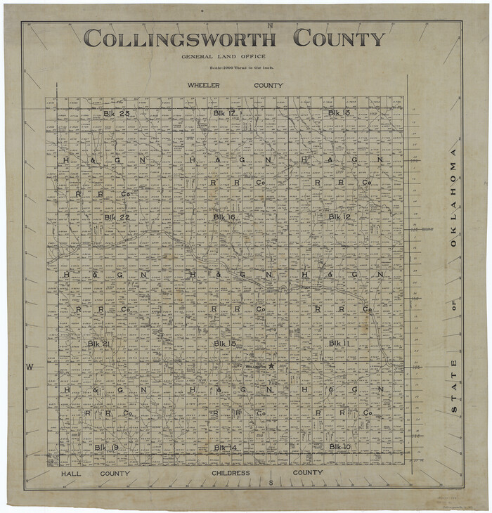
Collingsworth County
Print $20.00
- Digital $50.00
Collingsworth County
Size 42.4 x 40.6 inches
Map/Doc 66778
[The S.K. Ry. of Texas, State Line to Pecos, Reeves Co., Texas]
![64164, [The S.K. Ry. of Texas, State Line to Pecos, Reeves Co., Texas], General Map Collection](https://historictexasmaps.com/wmedia_w700/maps/64164.tif.jpg)
Print $40.00
- Digital $50.00
[The S.K. Ry. of Texas, State Line to Pecos, Reeves Co., Texas]
1910
Size 18.7 x 95.8 inches
Map/Doc 64164