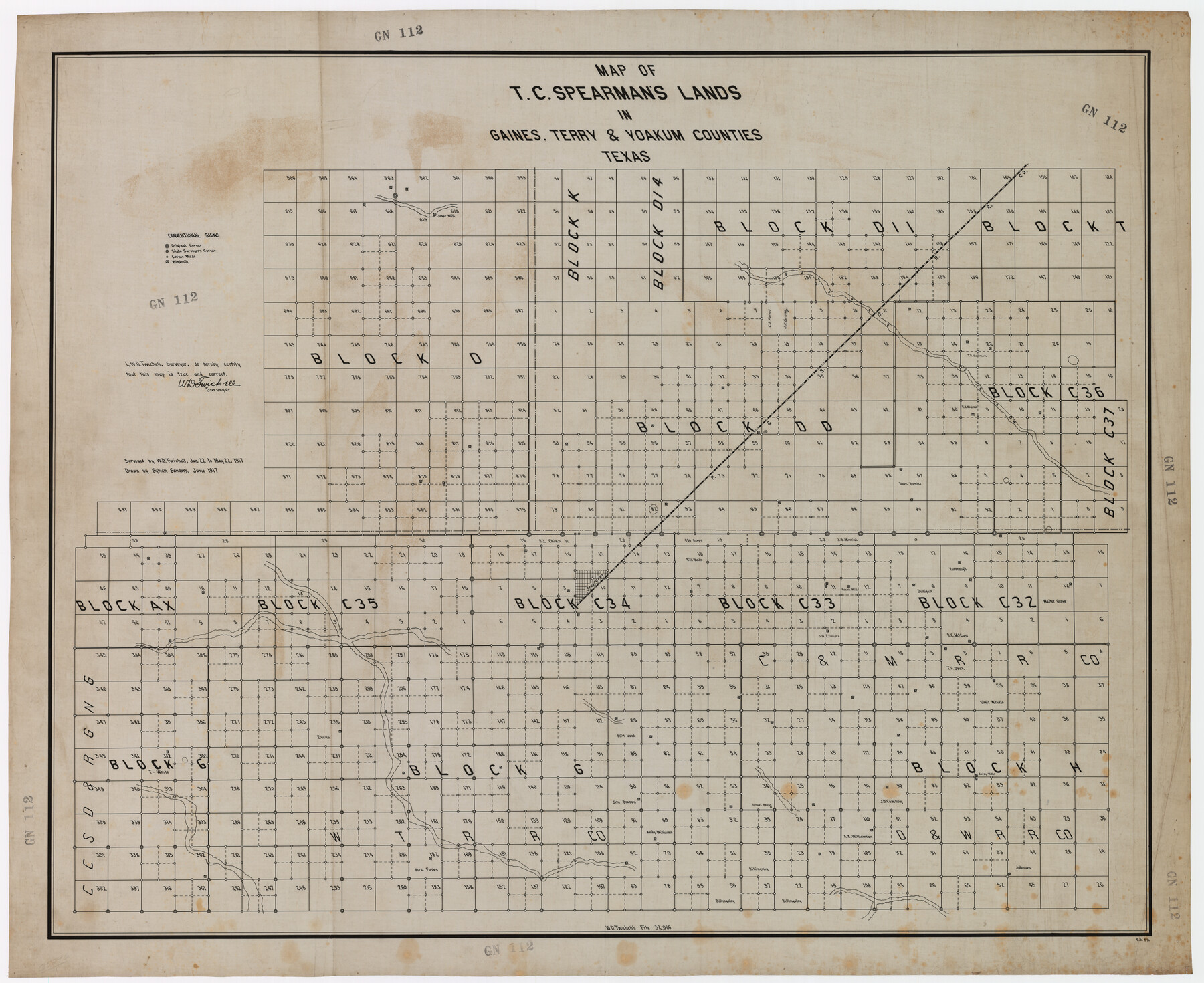
Map of T. C. Spearman's Lands in Gaines, Terry & Yoakum Counties, Texas
GN112
-
Map/Doc
89842
-
Collection
Twichell Survey Records
-
Object Dates
6/1917 (Creation Date)
-
People and Organizations
Sylvan Sanders (Draftsman)
W.D. Twichell (Surveyor/Engineer)
-
Counties
Gaines
-
Height x Width
46.0 x 37.6 inches
116.8 x 95.5 cm
Part of: Twichell Survey Records
[Plat showing connecting lines for the purpose of locating 4.3 acres in Caldwell County]
![90220, [Plat showing connecting lines for the purpose of locating 4.3 acres in Caldwell County], Twichell Survey Records](https://historictexasmaps.com/wmedia_w700/maps/90220-1.tif.jpg)
Print $2.00
- Digital $50.00
[Plat showing connecting lines for the purpose of locating 4.3 acres in Caldwell County]
1923
Size 7.4 x 10.2 inches
Map/Doc 90220
Blocks 2, 8, and 9. Capitol Syndicate Subdivision of Capitol Leagues or Portions of Capitol Leagues 59, 60, 61, 62, 63, 64, 65, 66, 69, 70, 71, 72, 73, 74, 75, 76, 83, 84, 85, 86, 87, 88, 89, 90, 91, 92, 108, 109, and 110. Dallam County, Texas

Print $20.00
- Digital $50.00
Blocks 2, 8, and 9. Capitol Syndicate Subdivision of Capitol Leagues or Portions of Capitol Leagues 59, 60, 61, 62, 63, 64, 65, 66, 69, 70, 71, 72, 73, 74, 75, 76, 83, 84, 85, 86, 87, 88, 89, 90, 91, 92, 108, 109, and 110. Dallam County, Texas
1906
Size 31.7 x 28.3 inches
Map/Doc 92581
Plains Addition to Seagraves, Gaines County, Texas

Print $20.00
- Digital $50.00
Plains Addition to Seagraves, Gaines County, Texas
1948
Size 30.0 x 33.0 inches
Map/Doc 92691
[I. & G. N. Block 1 and surroundings]
![91539, [I. & G. N. Block 1 and surroundings], Twichell Survey Records](https://historictexasmaps.com/wmedia_w700/maps/91539-1.tif.jpg)
Print $3.00
- Digital $50.00
[I. & G. N. Block 1 and surroundings]
1892
Size 11.9 x 17.2 inches
Map/Doc 91539
[Block M, Section 132, Dawson County, Texas]
![92631, [Block M, Section 132, Dawson County, Texas], Twichell Survey Records](https://historictexasmaps.com/wmedia_w700/maps/92631-1.tif.jpg)
Print $20.00
- Digital $50.00
[Block M, Section 132, Dawson County, Texas]
1951
Size 15.9 x 14.3 inches
Map/Doc 92631
[Sketch of area around Mary Fury and John P. Rohus Surveys]
![91917, [Sketch of area around Mary Fury and John P. Rohus Surveys], Twichell Survey Records](https://historictexasmaps.com/wmedia_w700/maps/91917-1.tif.jpg)
Print $20.00
- Digital $50.00
[Sketch of area around Mary Fury and John P. Rohus Surveys]
Size 19.4 x 19.7 inches
Map/Doc 91917
[Leagues 7, 8, 9, and 10]
![92218, [Leagues 7, 8, 9, and 10], Twichell Survey Records](https://historictexasmaps.com/wmedia_w700/maps/92218-1.tif.jpg)
Print $20.00
- Digital $50.00
[Leagues 7, 8, 9, and 10]
1943
Size 20.0 x 13.4 inches
Map/Doc 92218
[Sketch of Berry Doolittle, C. B. Emmons. R. D. Price and other surveys]
![90213, [Sketch of Berry Doolittle, C. B. Emmons. R. D. Price and other surveys], Twichell Survey Records](https://historictexasmaps.com/wmedia_w700/maps/90213-1.tif.jpg)
Print $20.00
- Digital $50.00
[Sketch of Berry Doolittle, C. B. Emmons. R. D. Price and other surveys]
Size 25.8 x 19.7 inches
Map/Doc 90213
[Sketch showing Blocks A, S4, O6, JK, O5, O2, O, JK4, JD, A2, A1]
![89713, [Sketch showing Blocks A, S4, O6, JK, O5, O2, O, JK4, JD, A2, A1], Twichell Survey Records](https://historictexasmaps.com/wmedia_w700/maps/89713-1.tif.jpg)
Print $40.00
- Digital $50.00
[Sketch showing Blocks A, S4, O6, JK, O5, O2, O, JK4, JD, A2, A1]
Size 48.9 x 37.6 inches
Map/Doc 89713
[NE Quarter Section 11 Block CK Lubbock County, Texas]
![92871, [NE Quarter Section 11 Block CK Lubbock County, Texas], Twichell Survey Records](https://historictexasmaps.com/wmedia_w700/maps/92871-1.tif.jpg)
Print $20.00
- Digital $50.00
[NE Quarter Section 11 Block CK Lubbock County, Texas]
1949
Size 16.1 x 16.5 inches
Map/Doc 92871
[Pencil sketch and calculations regarding section 34, Block 194]
![91663, [Pencil sketch and calculations regarding section 34, Block 194], Twichell Survey Records](https://historictexasmaps.com/wmedia_w700/maps/91663-1.tif.jpg)
Print $20.00
- Digital $50.00
[Pencil sketch and calculations regarding section 34, Block 194]
Size 23.0 x 12.1 inches
Map/Doc 91663
[Capitol Leagues along New Mexico Line]
![90766, [Capitol Leagues along New Mexico Line], Twichell Survey Records](https://historictexasmaps.com/wmedia_w700/maps/90766-1.tif.jpg)
Print $20.00
- Digital $50.00
[Capitol Leagues along New Mexico Line]
Size 8.2 x 22.7 inches
Map/Doc 90766
You may also like
Jasper County Sketch File 6

Print $26.00
- Digital $50.00
Jasper County Sketch File 6
1867
Size 12.8 x 8.2 inches
Map/Doc 27771
[Blocks 34-36, Township 1N]
![92031, [Blocks 34-36, Township 1N], Twichell Survey Records](https://historictexasmaps.com/wmedia_w700/maps/92031-1.tif.jpg)
Print $20.00
- Digital $50.00
[Blocks 34-36, Township 1N]
Size 36.8 x 23.8 inches
Map/Doc 92031
Bee County Sketch File 2

Print $40.00
- Digital $50.00
Bee County Sketch File 2
Size 14.3 x 13.0 inches
Map/Doc 14259
[Gulf Colorado & Santa Fe from 2178+36.0 to 3901+06.2]
![64698, [Gulf Colorado & Santa Fe from 2178+36.0 to 3901+06.2], General Map Collection](https://historictexasmaps.com/wmedia_w700/maps/64698.tif.jpg)
Print $40.00
- Digital $50.00
[Gulf Colorado & Santa Fe from 2178+36.0 to 3901+06.2]
Size 123.0 x 32.2 inches
Map/Doc 64698
[T. & P. Block 44, Township 1S]
![90893, [T. & P. Block 44, Township 1S], Twichell Survey Records](https://historictexasmaps.com/wmedia_w700/maps/90893-1.tif.jpg)
Print $20.00
- Digital $50.00
[T. & P. Block 44, Township 1S]
Size 21.5 x 10.1 inches
Map/Doc 90893
The Texarkana Gateway to Texas and the Southwest issued jointly by the Iron Mountain Route, the Cotton Belt Route, the Texas & Pacific Railway, and the International & Great Northern Railroad

The Texarkana Gateway to Texas and the Southwest issued jointly by the Iron Mountain Route, the Cotton Belt Route, the Texas & Pacific Railway, and the International & Great Northern Railroad
1896
Size 6.6 x 9.4 inches
Map/Doc 96585
Upton County Working Sketch 59

Print $20.00
- Digital $50.00
Upton County Working Sketch 59
1987
Size 21.5 x 34.3 inches
Map/Doc 69556

The Republic County of Sabine. December 29, 1845

Print $20.00
The Republic County of Sabine. December 29, 1845
2020
Size 17.6 x 21.7 inches
Map/Doc 96270
Flight Mission No. DQO-3K, Frame 32, Galveston County

Print $20.00
- Digital $50.00
Flight Mission No. DQO-3K, Frame 32, Galveston County
1952
Size 18.7 x 22.5 inches
Map/Doc 85073
Runnels County Sketch File 41

Print $20.00
Runnels County Sketch File 41
1892
Size 22.8 x 25.7 inches
Map/Doc 12271
Somervell County Working Sketch 7

Print $20.00
- Digital $50.00
Somervell County Working Sketch 7
2008
Size 27.9 x 34.2 inches
Map/Doc 88889