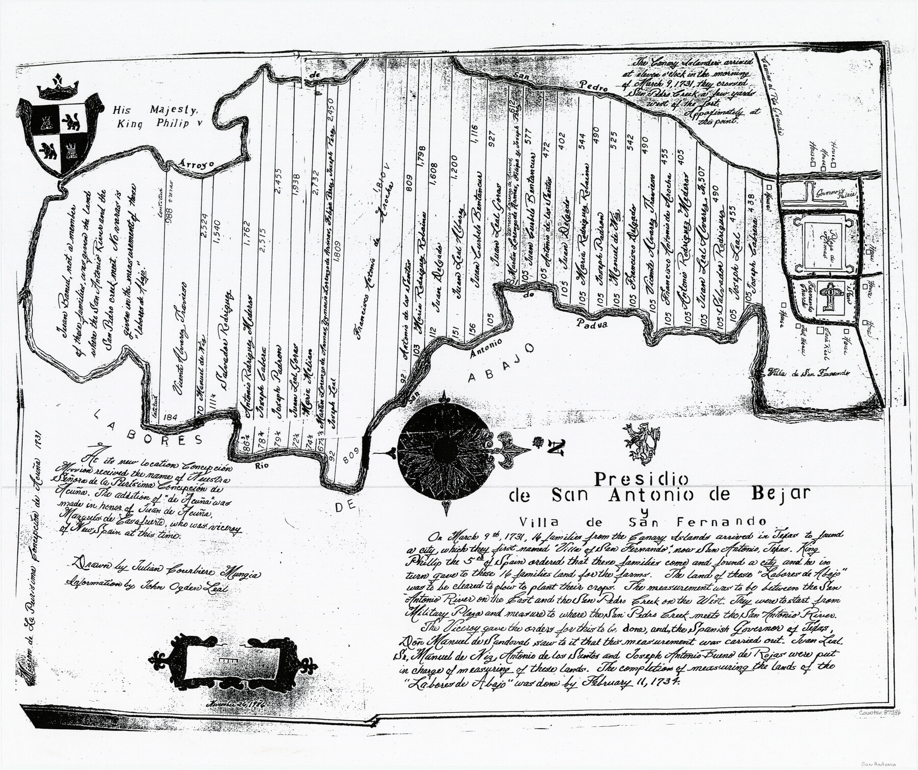
Presidio de San Antonio de Bejar y Villa de San Fernando
-
Map/Doc
87386
-
Collection
General Map Collection
-
Object Dates
1986/11/26 (Creation Date)
-
People and Organizations
Julian Courbiere Mungia (Draftsman)
John Ogden Leal (Compiler)
-
Counties
Bexar
-
Subjects
City Spanish Texas
-
Height x Width
21.8 x 26.0 inches
55.4 x 66.0 cm
-
Medium
paper, photocopy
-
Comments
Map was drawn November 26, 1986. In addition to the presidio and villa, it shows the location of the labores given to the 16 families ordered to move to the San Antonio area from the Canary Islands in 1734.
-
Features
Rio San Antonio Padua
Villa de San Fernando
Arroyo de San Pedro
Camino al Rio Grande
Governor's Palace
San Fernando Church
Mission de La Purisma Concepción de Acuña
San Antonio
Part of: General Map Collection
Flight Mission No. DAG-14K, Frame 146, Matagorda County

Print $20.00
- Digital $50.00
Flight Mission No. DAG-14K, Frame 146, Matagorda County
1952
Size 18.4 x 22.2 inches
Map/Doc 86313
Field Notes of a Survey of Padre Island

Print $20.00
- Digital $50.00
Field Notes of a Survey of Padre Island
1941
Size 43.2 x 30.0 inches
Map/Doc 2271
Harris County Sketch File 49

Print $10.00
- Digital $50.00
Harris County Sketch File 49
1908
Size 11.4 x 9.0 inches
Map/Doc 25446
Corpus Christi Pass, Texas

Print $20.00
- Digital $50.00
Corpus Christi Pass, Texas
1869
Size 24.3 x 18.2 inches
Map/Doc 72965
Brewster County Working Sketch 60

Print $20.00
- Digital $50.00
Brewster County Working Sketch 60
1955
Size 22.3 x 18.2 inches
Map/Doc 67661
Delta County Working Sketch 3

Print $20.00
- Digital $50.00
Delta County Working Sketch 3
1963
Size 24.9 x 24.4 inches
Map/Doc 68640

Brazoria County Sketch File 45

Print $20.00
- Digital $50.00
Brazoria County Sketch File 45
1980
Size 32.0 x 43.1 inches
Map/Doc 10326
Flight Mission No. BRE-2P, Frame 21, Nueces County

Print $20.00
- Digital $50.00
Flight Mission No. BRE-2P, Frame 21, Nueces County
1956
Size 18.5 x 22.3 inches
Map/Doc 86730
[Beaumont, Sour Lake and Western Ry. Right of Way and Alignment - Frisco]
![64132, [Beaumont, Sour Lake and Western Ry. Right of Way and Alignment - Frisco], General Map Collection](https://historictexasmaps.com/wmedia_w700/maps/64132.tif.jpg)
Print $20.00
- Digital $50.00
[Beaumont, Sour Lake and Western Ry. Right of Way and Alignment - Frisco]
1910
Size 19.9 x 46.1 inches
Map/Doc 64132

Angelina County Sketch File 11b

Print $6.00
- Digital $50.00
Angelina County Sketch File 11b
1859
Size 17.7 x 8.3 inches
Map/Doc 12944
You may also like
Flight Mission No. BRA-6M, Frame 94, Jefferson County

Print $20.00
- Digital $50.00
Flight Mission No. BRA-6M, Frame 94, Jefferson County
1953
Size 18.6 x 22.4 inches
Map/Doc 85437
Pecos County Sketch File 20

Print $20.00
- Digital $50.00
Pecos County Sketch File 20
Size 25.9 x 12.0 inches
Map/Doc 12160
Galveston County NRC Article 33.136 Sketch 100

Print $46.00
Galveston County NRC Article 33.136 Sketch 100
2024
Map/Doc 97423
Flight Mission No. DQN-2K, Frame 136, Calhoun County

Print $20.00
- Digital $50.00
Flight Mission No. DQN-2K, Frame 136, Calhoun County
1953
Size 18.5 x 15.8 inches
Map/Doc 84305
Texas, Matagorda Bay, Vicinity of Trespalacios Bay

Print $40.00
- Digital $50.00
Texas, Matagorda Bay, Vicinity of Trespalacios Bay
1933
Size 49.0 x 32.6 inches
Map/Doc 69988
Flight Mission No. CGI-4N, Frame 190, Cameron County

Print $20.00
- Digital $50.00
Flight Mission No. CGI-4N, Frame 190, Cameron County
1955
Size 18.5 x 22.2 inches
Map/Doc 84693
Midland County Rolled Sketch 4B

Print $40.00
- Digital $50.00
Midland County Rolled Sketch 4B
1951
Size 77.5 x 25.1 inches
Map/Doc 10725
Trinity County Sketch File 15

Print $6.00
- Digital $50.00
Trinity County Sketch File 15
Size 14.5 x 10.4 inches
Map/Doc 38542
Flight Mission No. DQN-2K, Frame 144, Calhoun County

Print $20.00
- Digital $50.00
Flight Mission No. DQN-2K, Frame 144, Calhoun County
1953
Size 18.7 x 22.4 inches
Map/Doc 84313
Right of Way and Track Map, the Missouri, Kansas and Texas Ry. of Texas - Henrietta Division

Print $20.00
- Digital $50.00
Right of Way and Track Map, the Missouri, Kansas and Texas Ry. of Texas - Henrietta Division
1918
Size 11.9 x 26.8 inches
Map/Doc 64753
Tom Green County Sketch File XXX

Print $20.00
- Digital $50.00
Tom Green County Sketch File XXX
Size 17.0 x 20.5 inches
Map/Doc 12457
Flight Mission No. BRE-2P, Frame 101, Nueces County

Print $20.00
- Digital $50.00
Flight Mission No. BRE-2P, Frame 101, Nueces County
1956
Size 18.4 x 22.2 inches
Map/Doc 86786