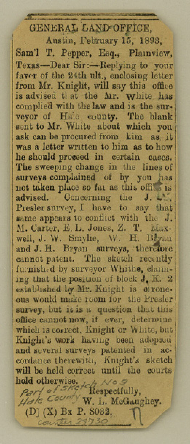
Hale County Sketch File 9
[Surveyor's statement regarding survey corners found]
-
Map/Doc
24730
-
Collection
General Map Collection
-
Object Dates
1893/2/27 (Creation Date)
1893/3/6 (File Date)
-
People and Organizations
H.C. Knight (Surveyor/Engineer)
Jonathan Summerfield (Surveyor/Engineer)
L.A. White (Surveyor/Engineer)
-
Counties
Hale
-
Subjects
Surveying Sketch File
-
Height x Width
6.1 x 2.6 inches
15.5 x 6.6 cm
-
Medium
multi-page, multi-format
Part of: General Map Collection
Cottle County Sketch File A and C

Print $68.00
- Digital $50.00
Cottle County Sketch File A and C
1902
Size 12.7 x 8.0 inches
Map/Doc 19422
Parker County Sketch File 8

Print $6.00
- Digital $50.00
Parker County Sketch File 8
1859
Size 11.0 x 11.5 inches
Map/Doc 33536
[Sketch for Mineral Application 1112 - Colorado River, H. E. Chambers]
![65642, [Sketch for Mineral Application 1112 - Colorado River, H. E. Chambers], General Map Collection](https://historictexasmaps.com/wmedia_w700/maps/65642.tif.jpg)
Print $20.00
- Digital $50.00
[Sketch for Mineral Application 1112 - Colorado River, H. E. Chambers]
1918
Size 17.1 x 28.4 inches
Map/Doc 65642
Grayson County, Fannin District

Print $20.00
- Digital $50.00
Grayson County, Fannin District
1885
Size 39.6 x 35.1 inches
Map/Doc 81942
Tarrant County Working Sketch 23

Print $20.00
- Digital $50.00
Tarrant County Working Sketch 23
2001
Size 15.9 x 15.6 inches
Map/Doc 62440
Sketch A Shewing the progress of the Survey in Section No. 1 From 1844 to 1851

Print $20.00
- Digital $50.00
Sketch A Shewing the progress of the Survey in Section No. 1 From 1844 to 1851
1851
Size 37.1 x 24.5 inches
Map/Doc 97202
Nueces County Sketch File 25B

Print $20.00
- Digital $50.00
Nueces County Sketch File 25B
1894
Size 17.6 x 24.6 inches
Map/Doc 42183
Harris County Sketch File 98

Print $50.00
- Digital $50.00
Harris County Sketch File 98
Size 11.2 x 9.1 inches
Map/Doc 25653
Fractional Township No. 9 South Range No. 23 East of the Indian Meridian, Indian Territory

Print $20.00
- Digital $50.00
Fractional Township No. 9 South Range No. 23 East of the Indian Meridian, Indian Territory
1898
Size 19.2 x 24.4 inches
Map/Doc 75240
Hunt County Working Sketch Graphic Index

Print $40.00
- Digital $50.00
Hunt County Working Sketch Graphic Index
1944
Size 50.5 x 37.0 inches
Map/Doc 76585
Bee County Sketch File 17

Print $4.00
- Digital $50.00
Bee County Sketch File 17
1878
Size 7.9 x 9.9 inches
Map/Doc 14301
Flight Mission No. DQN-1K, Frame 139, Calhoun County

Print $20.00
- Digital $50.00
Flight Mission No. DQN-1K, Frame 139, Calhoun County
1953
Size 18.4 x 22.3 inches
Map/Doc 84202
You may also like
[Sketch of Col. Cooke's Military Road expedition from Red River to Austin]
![82146, [Sketch of Col. Cooke's Military Road expedition from Red River to Austin], General Map Collection](https://historictexasmaps.com/wmedia_w700/maps/82146-1.tif.jpg)
Print $20.00
- Digital $50.00
[Sketch of Col. Cooke's Military Road expedition from Red River to Austin]
Size 33.4 x 23.4 inches
Map/Doc 82146
Cass County Working Sketch 53

Print $20.00
- Digital $50.00
Cass County Working Sketch 53
2007
Size 30.2 x 36.0 inches
Map/Doc 88608
Tourists' Handbook Descriptive of Colorado, New Mexico and Utah

Tourists' Handbook Descriptive of Colorado, New Mexico and Utah
1898
Size 9.4 x 6.4 inches
Map/Doc 97075
Old Miscellaneous File 19

Print $32.00
- Digital $50.00
Old Miscellaneous File 19
Size 14.2 x 8.8 inches
Map/Doc 75499
Kaufman County Boundary File 3a

Print $28.00
- Digital $50.00
Kaufman County Boundary File 3a
Size 14.2 x 8.6 inches
Map/Doc 55929
Donley County Working Sketch 2

Print $20.00
- Digital $50.00
Donley County Working Sketch 2
1916
Size 15.2 x 17.1 inches
Map/Doc 68735
La Salle County Working Sketch 15

Print $20.00
- Digital $50.00
La Salle County Working Sketch 15
1935
Size 27.4 x 17.2 inches
Map/Doc 70316
Map of Fort Bend County, Texas

Print $20.00
- Digital $50.00
Map of Fort Bend County, Texas
1897
Size 26.0 x 33.9 inches
Map/Doc 95883
Presidio County Sketch File 64a

Print $4.00
- Digital $50.00
Presidio County Sketch File 64a
1939
Size 11.3 x 8.8 inches
Map/Doc 34652
Andrews County Working Sketch 5

Print $20.00
- Digital $50.00
Andrews County Working Sketch 5
1954
Size 21.7 x 43.0 inches
Map/Doc 67051
Nueces County Rolled Sketch M-12

Print $20.00
- Digital $50.00
Nueces County Rolled Sketch M-12
1913
Size 24.9 x 40.0 inches
Map/Doc 7171
Pecos County Sketch File 28a

Print $20.00
- Digital $50.00
Pecos County Sketch File 28a
Size 24.3 x 26.6 inches
Map/Doc 12169