Flight Mission No. DAH-9M, Frame 154, Orange County
DAH-9M-154
-
Map/Doc
86853
-
Collection
General Map Collection
-
Object Dates
1953/4/19 (Creation Date)
-
People and Organizations
U. S. Department of Agriculture (Publisher)
-
Counties
Orange
-
Subjects
Aerial Photograph
-
Height x Width
18.3 x 22.3 inches
46.5 x 56.6 cm
-
Comments
Flown by Jack Ammann Photogrammetric Engineers of San Antonio, Texas.
Part of: General Map Collection
Johnson County

Print $20.00
- Digital $50.00
Johnson County
1943
Size 42.4 x 39.0 inches
Map/Doc 1868
A Map of the Indian Territory, Northern Texas and New Mexico showing the [G]reat Western Prairies
![97127, A Map of the Indian Territory, Northern Texas and New Mexico showing the [G]reat Western Prairies, General Map Collection](https://historictexasmaps.com/wmedia_w700/97127.tif.jpg)
Print $20.00
- Digital $50.00
A Map of the Indian Territory, Northern Texas and New Mexico showing the [G]reat Western Prairies
1844
Size 15.0 x 16.0 inches
Map/Doc 97127
San Luis Pass to East Matagorda Bay

Print $20.00
- Digital $50.00
San Luis Pass to East Matagorda Bay
1964
Size 34.7 x 46.6 inches
Map/Doc 69964
[Surveys along Tehuacano and Grindstone Creek, drawings X and Y]
![299, [Surveys along Tehuacano and Grindstone Creek, drawings X and Y], General Map Collection](https://historictexasmaps.com/wmedia_w700/maps/299.tif.jpg)
Print $20.00
- Digital $50.00
[Surveys along Tehuacano and Grindstone Creek, drawings X and Y]
1846
Size 12.4 x 18.3 inches
Map/Doc 299
Ellis County Sketch File 17

Print $40.00
- Digital $50.00
Ellis County Sketch File 17
1861
Size 12.9 x 16.1 inches
Map/Doc 21860
Shelby County Working Sketch 31a

Print $40.00
- Digital $50.00
Shelby County Working Sketch 31a
2003
Size 32.6 x 70.2 inches
Map/Doc 78643

Crockett County Sketch File 28

Print $10.00
- Digital $50.00
Crockett County Sketch File 28
1884
Size 13.1 x 8.9 inches
Map/Doc 19722
Comal County Sketch File 16

Print $4.00
- Digital $50.00
Comal County Sketch File 16
1878
Size 8.4 x 10.7 inches
Map/Doc 19034
Cottle County Rolled Sketch 7

Print $20.00
- Digital $50.00
Cottle County Rolled Sketch 7
Size 36.8 x 33.0 inches
Map/Doc 8675
[Surveys in Austin's Colony along the San Bernardo River, West Bernardo River, and Lone Tree Creek]
![194, [Surveys in Austin's Colony along the San Bernardo River, West Bernardo River, and Lone Tree Creek], General Map Collection](https://historictexasmaps.com/wmedia_w700/maps/194-1.tif.jpg)
Print $20.00
- Digital $50.00
[Surveys in Austin's Colony along the San Bernardo River, West Bernardo River, and Lone Tree Creek]
1830
Size 28.3 x 17.8 inches
Map/Doc 194
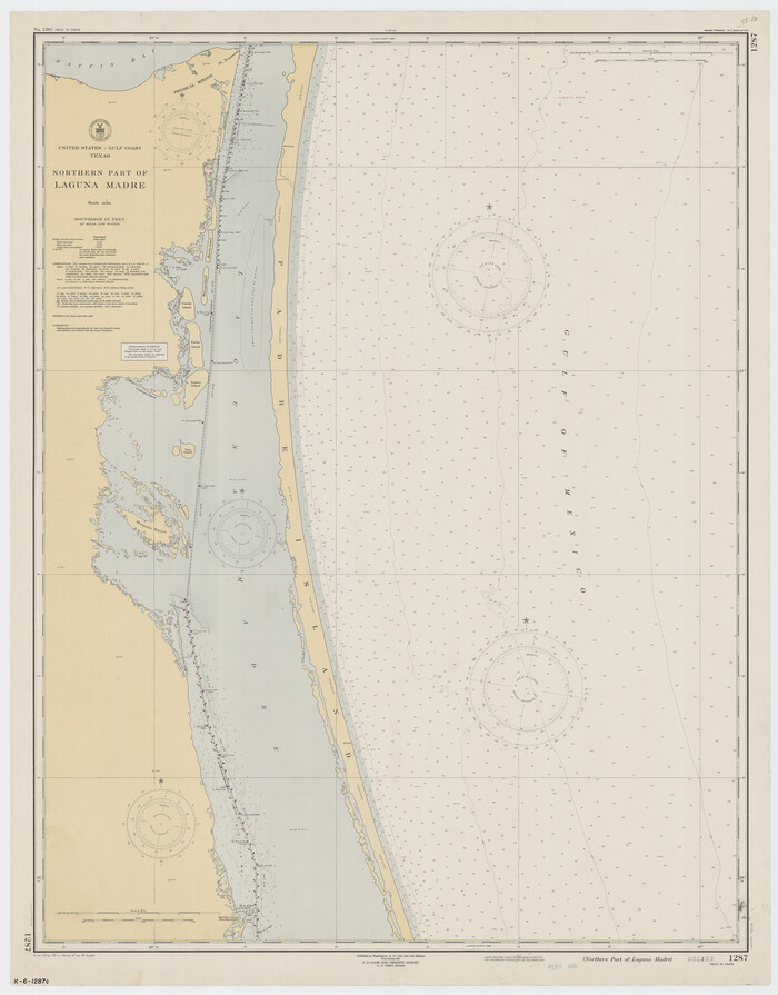
Northern Part of Laguna Madre
Print $20.00
- Digital $50.00
Northern Part of Laguna Madre
1949
Size 44.6 x 34.9 inches
Map/Doc 73524
You may also like
Comal County Rolled Sketch 2

Print $20.00
- Digital $50.00
Comal County Rolled Sketch 2
Size 21.6 x 13.0 inches
Map/Doc 5536
Current Miscellaneous File 48

Print $32.00
- Digital $50.00
Current Miscellaneous File 48
Size 11.2 x 8.7 inches
Map/Doc 73996
Gaines County Working Sketch 37

Print $20.00
- Digital $50.00
Gaines County Working Sketch 37
Size 21.5 x 16.6 inches
Map/Doc 69337
The Republic County of Victoria. Spring 1842

Print $20.00
The Republic County of Victoria. Spring 1842
2020
Size 24.3 x 21.7 inches
Map/Doc 96300
Flight Mission No. DQO-3K, Frame 32, Galveston County

Print $20.00
- Digital $50.00
Flight Mission No. DQO-3K, Frame 32, Galveston County
1952
Size 18.7 x 22.5 inches
Map/Doc 85073
Bee County Sketch File 26

Print $6.00
- Digital $50.00
Bee County Sketch File 26
1883
Size 14.5 x 9.0 inches
Map/Doc 14328
Sketch of Block B, GH & H RR & Blk C, CT RR Co, with surrounding & conflicting surveys in Knox & Baylor Counties

Print $20.00
- Digital $50.00
Sketch of Block B, GH & H RR & Blk C, CT RR Co, with surrounding & conflicting surveys in Knox & Baylor Counties
Size 24.9 x 17.9 inches
Map/Doc 75784
Hale County Boundary File 1

Print $44.00
- Digital $50.00
Hale County Boundary File 1
Size 10.0 x 30.9 inches
Map/Doc 54031

Bee County Sketch File 6

Print $6.00
- Digital $50.00
Bee County Sketch File 6
1860
Size 12.3 x 7.7 inches
Map/Doc 14272
[Corpus Christi Bay, Padre Island, Mustang Island, Laguna de la Madre, King and Kenedy's Pasture]
![73047, [Corpus Christi Bay, Padre Island, Mustang Island, Laguna de la Madre, King and Kenedy's Pasture], General Map Collection](https://historictexasmaps.com/wmedia_w700/maps/73047.tif.jpg)
Print $20.00
- Digital $50.00
[Corpus Christi Bay, Padre Island, Mustang Island, Laguna de la Madre, King and Kenedy's Pasture]
Size 18.2 x 26.0 inches
Map/Doc 73047
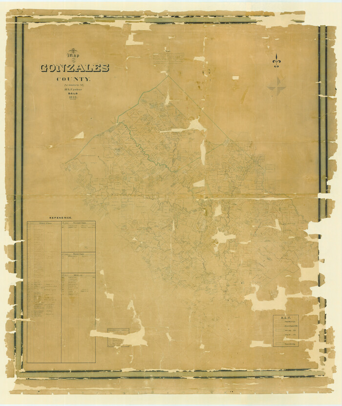
Map of Gonzales County
Print $40.00
- Digital $50.00
Map of Gonzales County
1842
Size 59.5 x 50.0 inches
Map/Doc 16839