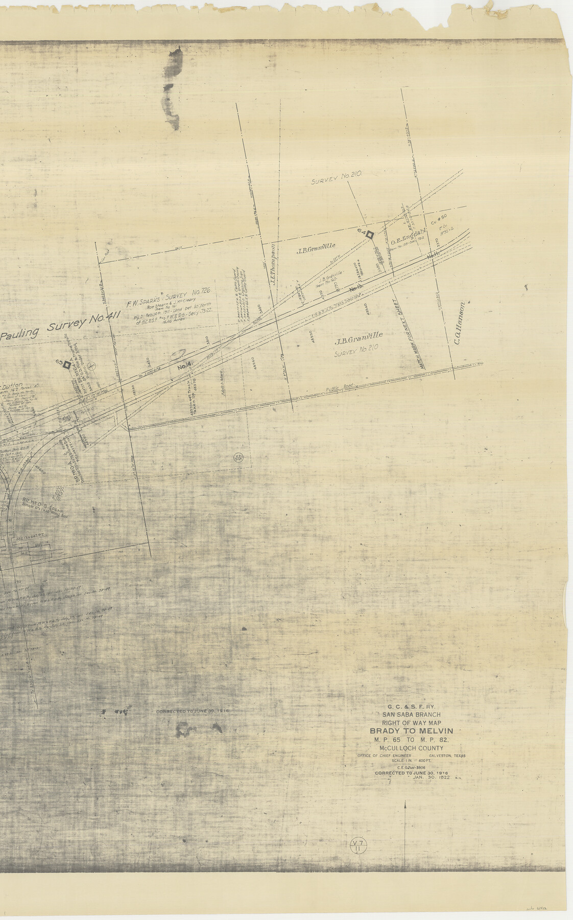
G. C. & S. F. Ry., San Saba Branch, Right of Way Map, Brady to Melvin
M.P. 65 to M.P. 82
Z-2-220, N.1.46
-
Map/Doc
61422
-
Collection
General Map Collection
-
Object Dates
1922/1/30 (Revision Date)
1916/6/30 (Creation Date)
-
People and Organizations
Office of Chief Engineer (Publisher)
-
Counties
McCulloch
-
Subjects
Railroads
-
Height x Width
36.9 x 23.0 inches
93.7 x 58.4 cm
-
Medium
paper, photocopy
-
Scale
1 inch = 400 feet
-
Comments
See 61420 and 61421 for other segments of this map.
-
Features
GC&SF
Part of: General Map Collection
Galveston County Rolled Sketch 44

Print $20.00
- Digital $50.00
Galveston County Rolled Sketch 44
1991
Size 24.9 x 36.9 inches
Map/Doc 5973
Flight Mission No. DIX-6P, Frame 197, Aransas County

Print $20.00
- Digital $50.00
Flight Mission No. DIX-6P, Frame 197, Aransas County
1956
Size 19.1 x 22.8 inches
Map/Doc 83859
Val Verde County Sketch File 51c

Print $6.00
- Digital $50.00
Val Verde County Sketch File 51c
1959
Size 10.9 x 16.9 inches
Map/Doc 39332
Lubbock County Sketch File 3

Print $4.00
- Digital $50.00
Lubbock County Sketch File 3
1901
Size 13.0 x 8.2 inches
Map/Doc 30420
North Half - Brown County, Texas

Print $40.00
- Digital $50.00
North Half - Brown County, Texas
1919
Size 42.2 x 64.8 inches
Map/Doc 97382
Flight Mission No. CUG-2P, Frame 85, Kleberg County

Print $20.00
- Digital $50.00
Flight Mission No. CUG-2P, Frame 85, Kleberg County
1956
Size 18.5 x 22.2 inches
Map/Doc 86217
Hardeman County Sketch File 3

Print $8.00
- Digital $50.00
Hardeman County Sketch File 3
1880
Size 14.2 x 8.8 inches
Map/Doc 24987
Parker County Sketch File 23

Print $20.00
- Digital $50.00
Parker County Sketch File 23
1876
Size 18.8 x 22.8 inches
Map/Doc 12145
Cottle County Rolled Sketch 12

Print $20.00
- Digital $50.00
Cottle County Rolled Sketch 12
1963
Size 34.2 x 25.7 inches
Map/Doc 5549
Bandera County Sketch File 22

Print $4.00
- Digital $50.00
Bandera County Sketch File 22
Size 12.6 x 7.9 inches
Map/Doc 14012
Henderson County Working Sketch 5

Print $20.00
- Digital $50.00
Henderson County Working Sketch 5
1918
Size 19.2 x 23.5 inches
Map/Doc 66138
Pecos County Working Sketch 9

Print $20.00
- Digital $50.00
Pecos County Working Sketch 9
1907
Size 32.4 x 26.7 inches
Map/Doc 71479
You may also like
Menard County Sketch File 3

Print $40.00
- Digital $50.00
Menard County Sketch File 3
Size 16.3 x 12.9 inches
Map/Doc 31488
Traveller's Map of the State of Texas

Print $20.00
Traveller's Map of the State of Texas
1867
Size 42.5 x 41.1 inches
Map/Doc 76226
Correct Map of Texas

Print $20.00
- Digital $50.00
Correct Map of Texas
1904
Size 17.9 x 22.3 inches
Map/Doc 95768
North Sulphur River, Bartley Gin Sheet

Print $20.00
- Digital $50.00
North Sulphur River, Bartley Gin Sheet
1928
Size 13.3 x 22.0 inches
Map/Doc 78323
Matagorda County Sketch File 7a

Print $8.00
- Digital $50.00
Matagorda County Sketch File 7a
1890
Size 14.2 x 8.9 inches
Map/Doc 30740
![88993, San Jacinto Co[unty], Library of Congress](https://historictexasmaps.com/wmedia_w700/maps/88993.tif.jpg)
Sec. 22, Block 103

Print $2.00
- Digital $50.00
Sec. 22, Block 103
Size 8.4 x 9.5 inches
Map/Doc 90431

[T. & P. Block 43, Township 1N]
![90827, [T. & P. Block 43, Township 1N], Twichell Survey Records](https://historictexasmaps.com/wmedia_w700/maps/90827-2.tif.jpg)
Print $20.00
- Digital $50.00
[T. & P. Block 43, Township 1N]
Size 23.0 x 17.8 inches
Map/Doc 90827
[Working Sketch in Martin County Showing Northwest Portion of County]
![91355, [Working Sketch in Martin County Showing Northwest Portion of County], Twichell Survey Records](https://historictexasmaps.com/wmedia_w700/maps/91355-1.tif.jpg)
Print $20.00
- Digital $50.00
[Working Sketch in Martin County Showing Northwest Portion of County]
1902
Size 17.1 x 36.0 inches
Map/Doc 91355
Map of Martin County

Print $20.00
- Digital $50.00
Map of Martin County
1900
Size 41.9 x 35.0 inches
Map/Doc 4789
Dallas County Working Sketch 5

Print $20.00
- Digital $50.00
Dallas County Working Sketch 5
1941
Size 18.7 x 16.4 inches
Map/Doc 68571