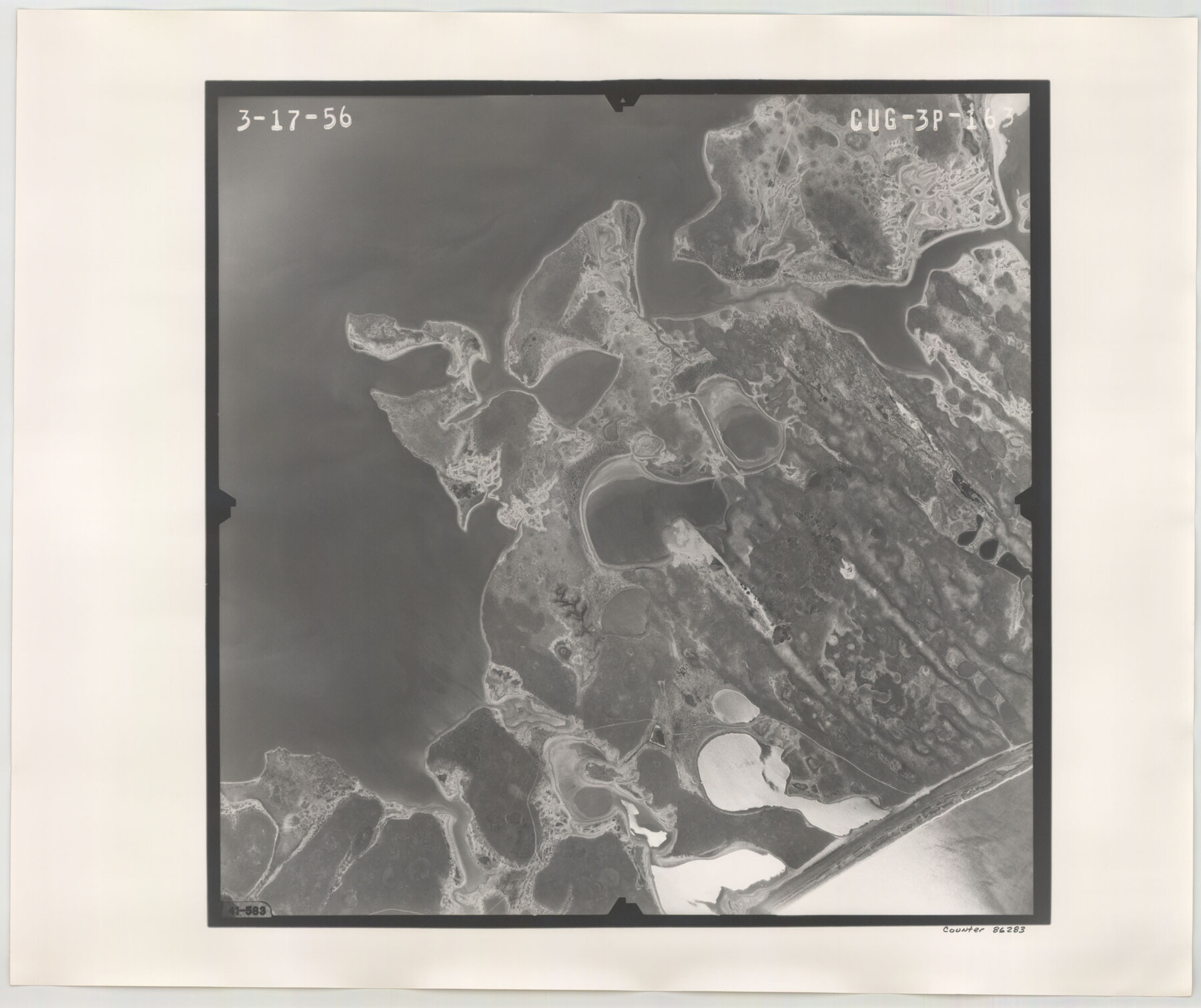
Flight Mission No. CUG-3P, Frame 163, Kleberg County
CUG-3P-163
-
Map/Doc
86283
-
Collection
General Map Collection
-
Object Dates
1956/3/17 (Creation Date)
-
People and Organizations
U. S. Department of Agriculture (Publisher)
-
Counties
Kleberg
-
Subjects
Aerial Photograph
-
Height x Width
18.6 x 22.2 inches
47.2 x 56.4 cm
-
Comments
Flown by V. L. Beavers and Associates of San Antonio, Texas.
Part of: General Map Collection
Travis County Sketch File 22

Print $6.00
- Digital $50.00
Travis County Sketch File 22
1875
Size 8.5 x 8.5 inches
Map/Doc 38327
[St. L. S-W. Ry. of Texas Map of Lufkin Branch in Angelina County, Texas]
![64560, [St. L. S-W. Ry. of Texas Map of Lufkin Branch in Angelina County, Texas], General Map Collection](https://historictexasmaps.com/wmedia_w700/maps/64560-1.tif.jpg)
Print $40.00
- Digital $50.00
[St. L. S-W. Ry. of Texas Map of Lufkin Branch in Angelina County, Texas]
1913
Size 25.7 x 121.3 inches
Map/Doc 64560
Liberty County Sketch File 14

Print $4.00
- Digital $50.00
Liberty County Sketch File 14
1858
Size 12.9 x 8.1 inches
Map/Doc 29915
Concho County Rolled Sketch 3

Print $40.00
- Digital $50.00
Concho County Rolled Sketch 3
1949
Size 67.0 x 46.0 inches
Map/Doc 8648
Reagan County Working Sketch 41

Print $20.00
- Digital $50.00
Reagan County Working Sketch 41
1973
Size 28.6 x 38.9 inches
Map/Doc 71883
Rusk County Working Sketch 12

Print $20.00
- Digital $50.00
Rusk County Working Sketch 12
1979
Size 17.0 x 15.8 inches
Map/Doc 63647
Kendall County Working Sketch 25

Print $40.00
- Digital $50.00
Kendall County Working Sketch 25
1978
Size 39.4 x 56.8 inches
Map/Doc 66697
Erath County Sketch File 8a

Print $6.00
- Digital $50.00
Erath County Sketch File 8a
1853
Size 15.9 x 11.0 inches
Map/Doc 22271
Angelina County Sketch File 4

Print $4.00
- Digital $50.00
Angelina County Sketch File 4
1854
Size 8.3 x 9.0 inches
Map/Doc 12926
[Sketch for Mineral Application 16700 - Pecos River Bed]
![2806, [Sketch for Mineral Application 16700 - Pecos River Bed], General Map Collection](https://historictexasmaps.com/wmedia_w700/maps/2806.tif.jpg)
Print $20.00
- Digital $50.00
[Sketch for Mineral Application 16700 - Pecos River Bed]
1927
Size 20.3 x 29.1 inches
Map/Doc 2806
Kimble County Rolled Sketch 35

Print $20.00
- Digital $50.00
Kimble County Rolled Sketch 35
1978
Size 20.0 x 19.6 inches
Map/Doc 6525
Jeff Davis County Sketch File 39

Print $10.00
- Digital $50.00
Jeff Davis County Sketch File 39
Size 14.2 x 8.7 inches
Map/Doc 28057
You may also like
Harris County Working Sketch 68

Print $20.00
- Digital $50.00
Harris County Working Sketch 68
1955
Size 29.3 x 24.3 inches
Map/Doc 65960
Railroad Track Map, H&TCRRCo., Falls County, Texas

Print $4.00
- Digital $50.00
Railroad Track Map, H&TCRRCo., Falls County, Texas
1918
Size 11.7 x 18.5 inches
Map/Doc 62839
Sterling County Sketch File 22

Print $4.00
- Digital $50.00
Sterling County Sketch File 22
1954
Size 11.2 x 8.7 inches
Map/Doc 37182
Cooke County Boundary File 1

Print $4.00
- Digital $50.00
Cooke County Boundary File 1
Size 12.6 x 7.5 inches
Map/Doc 51826
Concho County Sketch File 2

Print $4.00
- Digital $50.00
Concho County Sketch File 2
1859
Size 10.5 x 8.5 inches
Map/Doc 19122
Wise County Sketch File 7

Print $4.00
- Digital $50.00
Wise County Sketch File 7
1857
Size 8.1 x 14.0 inches
Map/Doc 40535
Fisher County Working Sketch 1

Print $20.00
- Digital $50.00
Fisher County Working Sketch 1
1911
Size 37.6 x 26.4 inches
Map/Doc 69135
Pecos County Working Sketch 101

Print $20.00
- Digital $50.00
Pecos County Working Sketch 101
1970
Size 43.3 x 31.1 inches
Map/Doc 71574
Sketch in Cochran County, Texas

Print $20.00
- Digital $50.00
Sketch in Cochran County, Texas
1949
Size 22.4 x 21.6 inches
Map/Doc 92523
The Republic County of Shelby. December 14, 1837

Print $20.00
The Republic County of Shelby. December 14, 1837
2020
Size 21.1 x 21.7 inches
Map/Doc 96279
Culberson County Sketch File 13

Print $16.00
- Digital $50.00
Culberson County Sketch File 13
1912
Size 11.2 x 8.7 inches
Map/Doc 20146
University Land in Grayson County in Two Parts

Print $20.00
- Digital $50.00
University Land in Grayson County in Two Parts
Size 30.6 x 25.8 inches
Map/Doc 62965