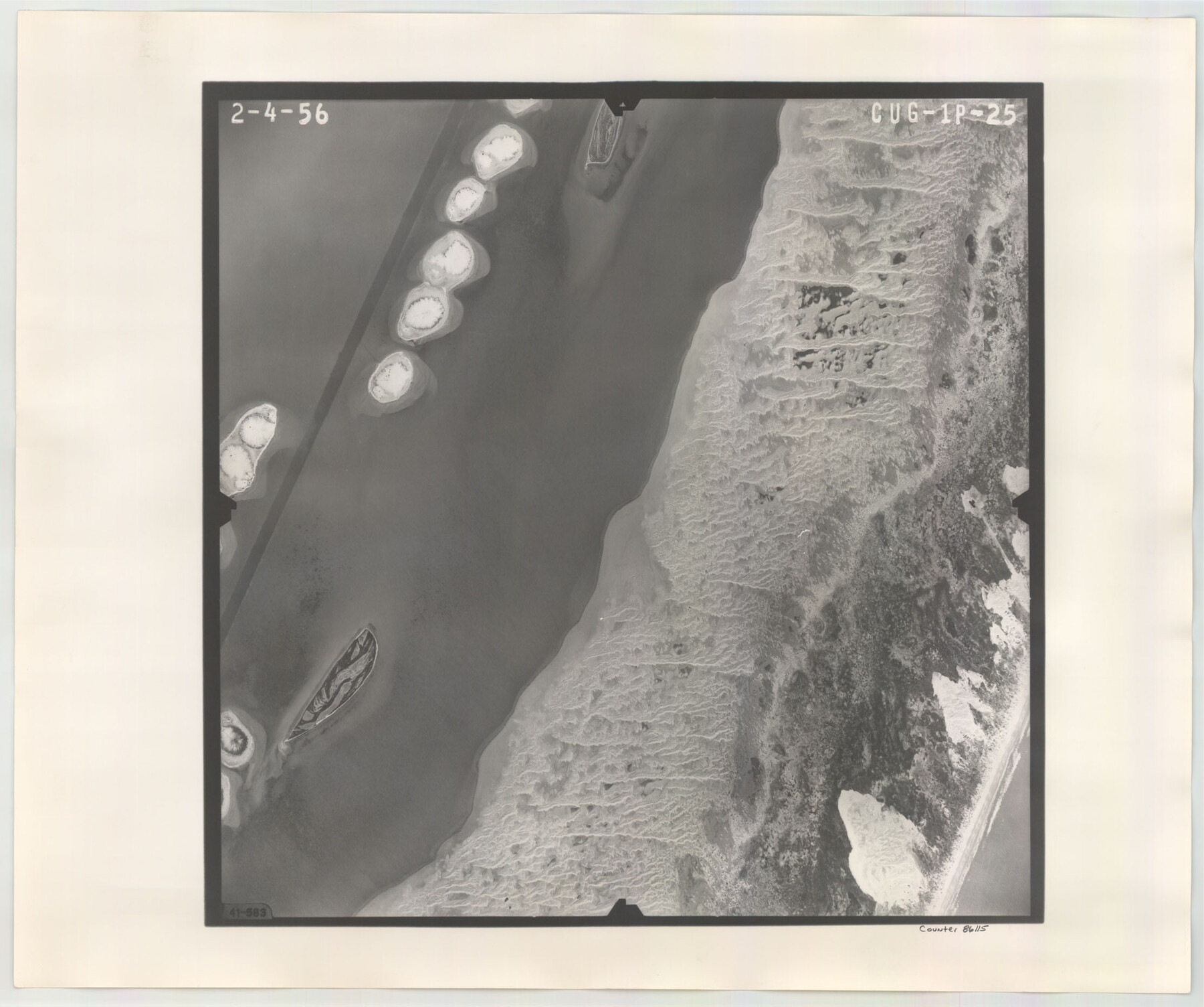
Flight Mission No. CUG-1P, Frame 25, Kleberg County
CUG-1P-25
-
Map/Doc
86115
-
Collection
General Map Collection
-
Object Dates
1956/2/4 (Creation Date)
-
People and Organizations
U. S. Department of Agriculture (Publisher)
-
Counties
Kleberg
-
Subjects
Aerial Photograph
-
Height x Width
18.6 x 22.3 inches
47.2 x 56.6 cm
-
Comments
Flown by V. L. Beavers and Associates of San Antonio, Texas.
Part of: General Map Collection
Red River County Working Sketch 15

Print $4.00
- Digital $50.00
Red River County Working Sketch 15
1953
Size 25.8 x 23.4 inches
Map/Doc 71998
Kimble County Working Sketch 71

Print $20.00
- Digital $50.00
Kimble County Working Sketch 71
1965
Size 47.1 x 22.0 inches
Map/Doc 70139
Flight Mission No. DIX-8P, Frame 64, Aransas County

Print $20.00
- Digital $50.00
Flight Mission No. DIX-8P, Frame 64, Aransas County
1956
Size 18.7 x 22.4 inches
Map/Doc 83895
Flight Mission No. BRA-7M, Frame 186, Jefferson County

Print $20.00
- Digital $50.00
Flight Mission No. BRA-7M, Frame 186, Jefferson County
1953
Size 18.4 x 22.2 inches
Map/Doc 85554
Cass County Working Sketch 24

Print $20.00
- Digital $50.00
Cass County Working Sketch 24
1973
Size 35.6 x 27.7 inches
Map/Doc 67927
Presidio County Sketch File 54

Print $4.00
- Digital $50.00
Presidio County Sketch File 54
Size 14.3 x 8.8 inches
Map/Doc 34620
Right of Way and Track Map, Texas & New Orleans R.R. operated by the T. & N. O. R.R. Co., Rusk Branch

Print $40.00
- Digital $50.00
Right of Way and Track Map, Texas & New Orleans R.R. operated by the T. & N. O. R.R. Co., Rusk Branch
1918
Size 24.9 x 55.9 inches
Map/Doc 64242
Kerr County Sketch File 20

Print $22.00
- Digital $50.00
Kerr County Sketch File 20
1951
Size 12.9 x 18.3 inches
Map/Doc 28890
Foard County Sketch File 32

Print $4.00
- Digital $50.00
Foard County Sketch File 32
1950
Size 14.5 x 9.0 inches
Map/Doc 22864
Montgomery County Working Sketch 64

Print $20.00
- Digital $50.00
Montgomery County Working Sketch 64
1965
Size 27.9 x 33.7 inches
Map/Doc 71171
Tarrant County

Print $20.00
- Digital $50.00
Tarrant County
1942
Size 46.7 x 38.0 inches
Map/Doc 63057

You may also like
Survey of Lots 1, 2, 3, 4 and 5, Block 12G Fair View Park, Austin Texas

Print $20.00
- Digital $50.00
Survey of Lots 1, 2, 3, 4 and 5, Block 12G Fair View Park, Austin Texas
1914
Size 23.1 x 11.0 inches
Map/Doc 83431
Polk County Sketch File 2a

Print $4.00
- Digital $50.00
Polk County Sketch File 2a
1863
Size 12.2 x 8.1 inches
Map/Doc 34120

[North part of G. C. & S. F. Block OP, Runnels County School Land and Blks. AB, CD and GH]
![90310, [North part of G. C. & S. F. Block OP, Runnels County School Land and Blks. AB, CD and GH], Twichell Survey Records](https://historictexasmaps.com/wmedia_w700/maps/90310-1.tif.jpg)
Print $20.00
- Digital $50.00
[North part of G. C. & S. F. Block OP, Runnels County School Land and Blks. AB, CD and GH]
Size 17.5 x 22.4 inches
Map/Doc 90310
Val Verde County Sketch File Z18

Print $4.00
- Digital $50.00
Val Verde County Sketch File Z18
1910
Size 14.0 x 8.8 inches
Map/Doc 39148
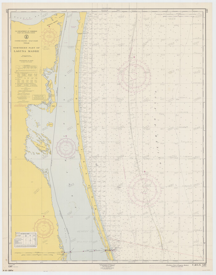
Northern Part of Laguna Madre
Print $20.00
- Digital $50.00
Northern Part of Laguna Madre
1965
Size 44.5 x 35.0 inches
Map/Doc 73526
[Morris County School Land and vicinity]
![90360, [Morris County School Land and vicinity], Twichell Survey Records](https://historictexasmaps.com/wmedia_w700/maps/90360-1.tif.jpg)
Print $20.00
- Digital $50.00
[Morris County School Land and vicinity]
Size 14.2 x 13.0 inches
Map/Doc 90360
Brewster County Rolled Sketch 88

Print $20.00
- Digital $50.00
Brewster County Rolled Sketch 88
1948
Size 23.7 x 19.7 inches
Map/Doc 5248
Flight Mission No. CLL-4N, Frame 32, Willacy County

Print $20.00
- Digital $50.00
Flight Mission No. CLL-4N, Frame 32, Willacy County
1954
Size 18.5 x 22.1 inches
Map/Doc 87105
Presidio County Sketch File 50

Print $8.00
- Digital $50.00
Presidio County Sketch File 50
1919
Size 13.3 x 8.8 inches
Map/Doc 34586
Map of Texas with Parts of the Adjoining States

Print $20.00
Map of Texas with Parts of the Adjoining States
1833
Size 29.3 x 23.3 inches
Map/Doc 79740
Flight Mission No. DIX-10P, Frame 76, Aransas County

Print $20.00
- Digital $50.00
Flight Mission No. DIX-10P, Frame 76, Aransas County
1956
Size 18.8 x 22.4 inches
Map/Doc 83937