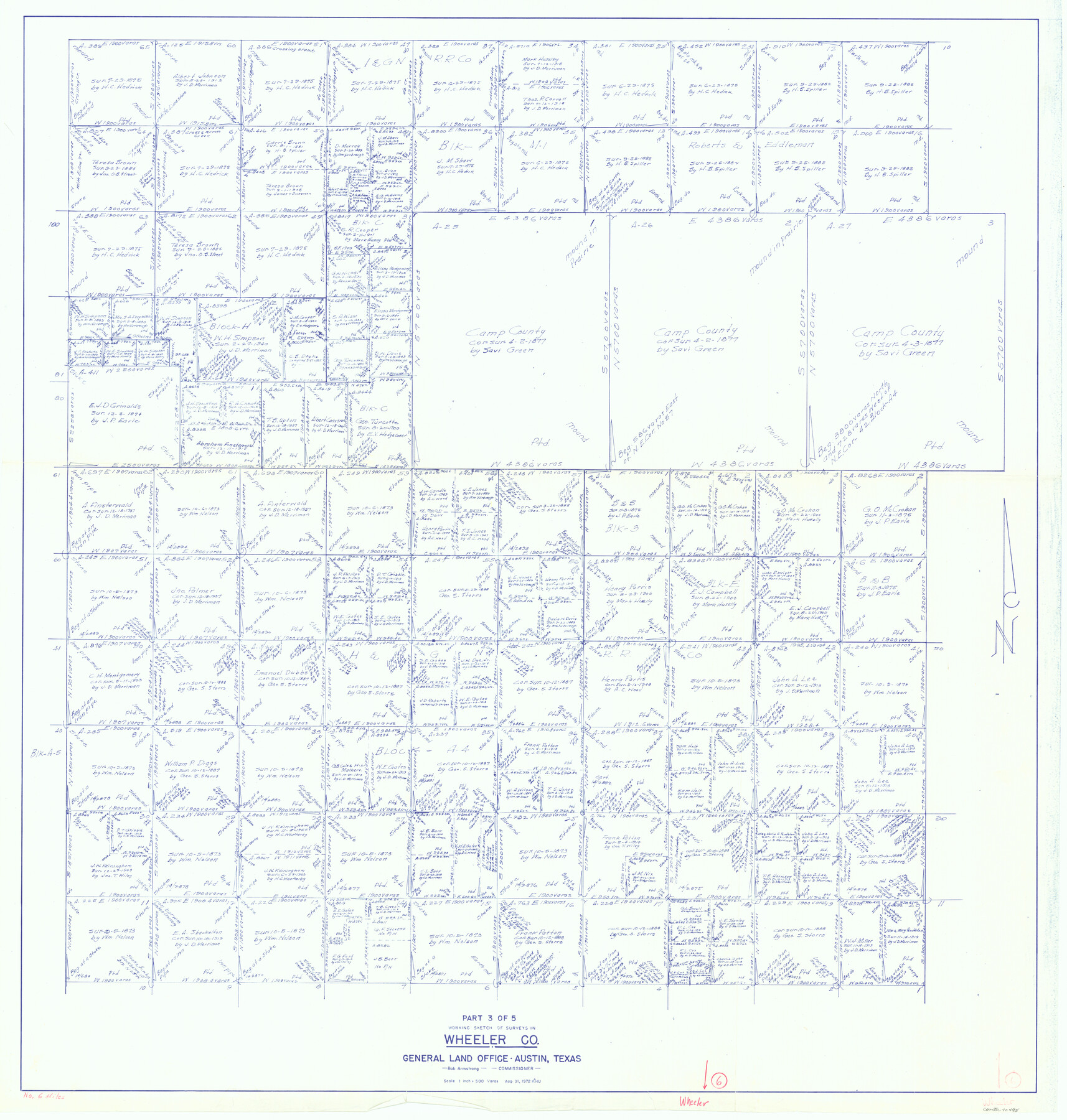
Wheeler County Working Sketch 6
-
Map/Doc
72495
-
Collection
General Map Collection
-
Object Dates
8/31/1972 (Creation Date)
-
People and Organizations
Herbert H. Ulbricht (Draftsman)
-
Counties
Wheeler
-
Subjects
Surveying Working Sketch
-
Height x Width
49.8 x 47.4 inches
126.5 x 120.4 cm
-
Scale
1" = 500 varas
Part of: General Map Collection
Duval County Working Sketch 35

Print $20.00
- Digital $50.00
Duval County Working Sketch 35
1956
Size 17.2 x 16.5 inches
Map/Doc 68759
United States - Gulf Coast - From Latitude 26° 33' to the Rio Grande Texas

Print $20.00
- Digital $50.00
United States - Gulf Coast - From Latitude 26° 33' to the Rio Grande Texas
1918
Size 27.7 x 18.2 inches
Map/Doc 72850

Jasper County Sketch File 34

Print $4.00
- Digital $50.00
Jasper County Sketch File 34
1873
Size 12.4 x 8.1 inches
Map/Doc 27868
Pecos County Sketch File 33

Print $40.00
- Digital $50.00
Pecos County Sketch File 33
1935
Size 8.9 x 20.7 inches
Map/Doc 33712
Township No. 2 South Range No. 24 West of the Indian Meridian

Print $20.00
- Digital $50.00
Township No. 2 South Range No. 24 West of the Indian Meridian
1875
Size 19.3 x 24.4 inches
Map/Doc 75174
Atascosa County Rolled Sketch 5

Print $20.00
- Digital $50.00
Atascosa County Rolled Sketch 5
1910
Size 22.1 x 15.8 inches
Map/Doc 5088

Flight Mission No. CRC-4R, Frame 104, Chambers County

Print $20.00
- Digital $50.00
Flight Mission No. CRC-4R, Frame 104, Chambers County
1956
Size 18.6 x 22.4 inches
Map/Doc 84901
Dickens County Sketch File L

Print $22.00
- Digital $50.00
Dickens County Sketch File L
1909
Size 7.7 x 9.0 inches
Map/Doc 20892
Flight Mission No. CGI-3N, Frame 52, Cameron County

Print $20.00
- Digital $50.00
Flight Mission No. CGI-3N, Frame 52, Cameron County
1954
Size 18.7 x 22.2 inches
Map/Doc 84558
Val Verde County Working Sketch 69

Print $20.00
- Digital $50.00
Val Verde County Working Sketch 69
1965
Size 35.6 x 37.3 inches
Map/Doc 72204
You may also like
San Jacinto County Sketch File 11

Print $4.00
San Jacinto County Sketch File 11
1859
Size 9.4 x 7.3 inches
Map/Doc 35718
Victoria County Sketch File 12

Print $4.00
- Digital $50.00
Victoria County Sketch File 12
1978
Size 11.4 x 8.9 inches
Map/Doc 39540
Sketch of part of Brazos Island

Print $20.00
- Digital $50.00
Sketch of part of Brazos Island
1863
Size 25.1 x 18.2 inches
Map/Doc 72923
Duval County Sketch File 41

Print $20.00
- Digital $50.00
Duval County Sketch File 41
1936
Size 19.6 x 17.2 inches
Map/Doc 11397
Lighthouse establishment on the Atlantic and Gulf Coasts and coast signal stations

Print $20.00
- Digital $50.00
Lighthouse establishment on the Atlantic and Gulf Coasts and coast signal stations
1898
Size 24.9 x 18.3 inches
Map/Doc 73050
Map of Madison County

Print $20.00
- Digital $50.00
Map of Madison County
1880
Size 17.0 x 24.9 inches
Map/Doc 3832
Map of surveys 189 & 190 T. C. R.R. Co. in Travis County, Texas

Print $20.00
- Digital $50.00
Map of surveys 189 & 190 T. C. R.R. Co. in Travis County, Texas
1915
Size 16.1 x 24.0 inches
Map/Doc 5079
Burleson County Working Sketch 22

Print $20.00
- Digital $50.00
Burleson County Working Sketch 22
1980
Size 14.6 x 15.6 inches
Map/Doc 67741
Flight Mission No. CRC-4R, Frame 97, Chambers County

Print $20.00
- Digital $50.00
Flight Mission No. CRC-4R, Frame 97, Chambers County
1956
Size 18.6 x 22.2 inches
Map/Doc 84894
Starr County Sketch File 8

Print $7.00
- Digital $50.00
Starr County Sketch File 8
Size 10.1 x 12.4 inches
Map/Doc 36858
Gonzales County Working Sketch 13

Print $2.00
- Digital $50.00
Gonzales County Working Sketch 13
1981
Size 12.5 x 7.6 inches
Map/Doc 63229
[Travis District]
![88740, [Travis District], General Map Collection](https://historictexasmaps.com/wmedia_w700/maps/88740.tif.jpg)
Print $40.00
- Digital $50.00
[Travis District]
1840
Size 54.7 x 46.0 inches
Map/Doc 88740