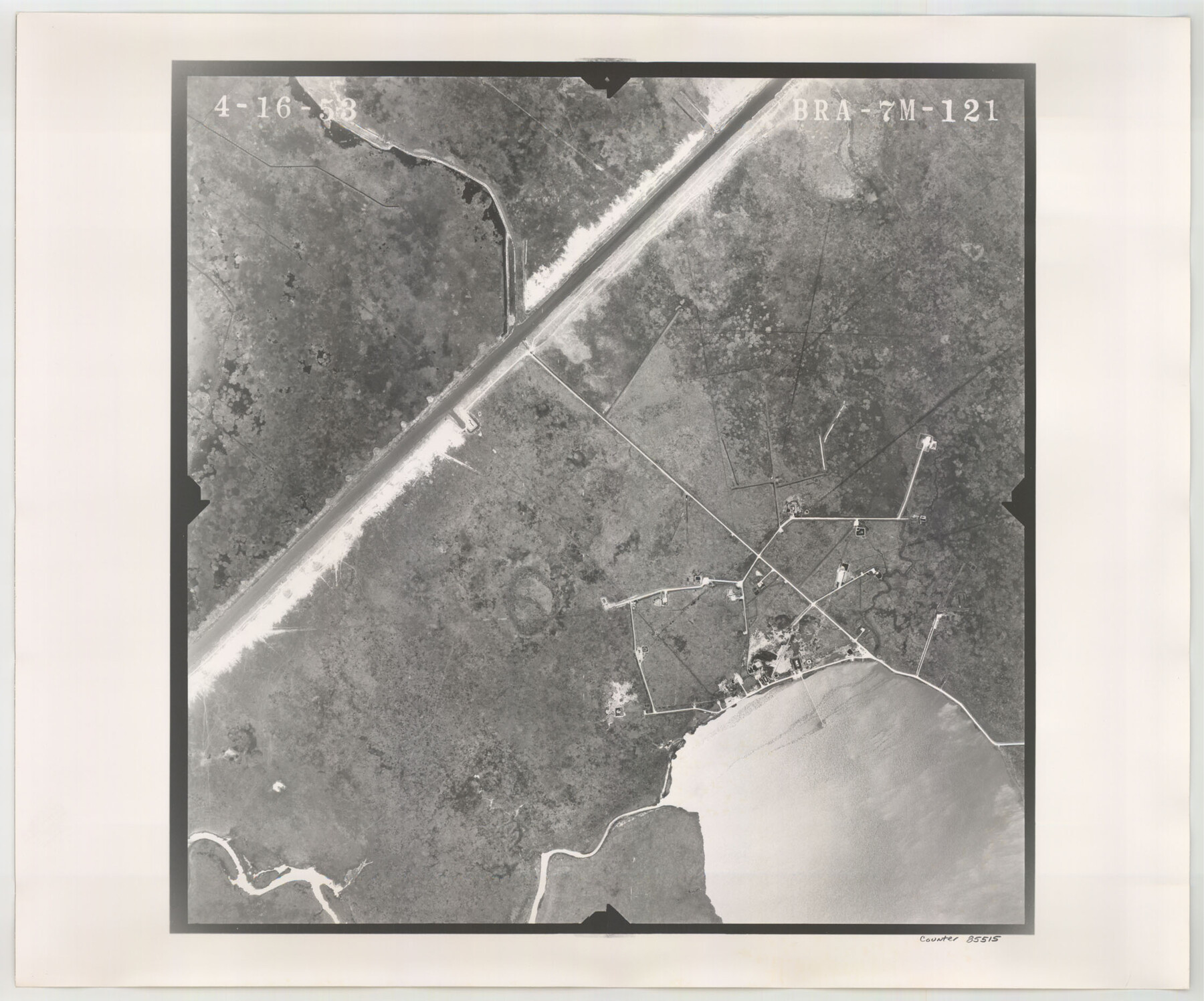
Flight Mission No. BRA-7M, Frame 121, Jefferson County
BRA-7M-121
-
Map/Doc
85515
-
Collection
General Map Collection
-
Object Dates
1953/4/16 (Creation Date)
-
People and Organizations
U. S. Department of Agriculture (Publisher)
-
Counties
Jefferson
-
Subjects
Aerial Photograph
-
Height x Width
18.6 x 22.4 inches
47.2 x 56.9 cm
-
Comments
Flown by Jack Ammann Photogrammetric Engineers of San Antonio, Texas.
Part of: General Map Collection
Falls County Boundary File 1

Print $64.00
- Digital $50.00
Falls County Boundary File 1
Size 9.2 x 4.4 inches
Map/Doc 53241
Wise County Fannin District

Print $20.00
- Digital $50.00
Wise County Fannin District
1878
Size 27.3 x 21.2 inches
Map/Doc 4164
Brewster County Working Sketch 75

Print $20.00
- Digital $50.00
Brewster County Working Sketch 75
1967
Size 28.3 x 36.9 inches
Map/Doc 67675
Hemphill County Rolled Sketch 19

Print $20.00
- Digital $50.00
Hemphill County Rolled Sketch 19
Size 31.2 x 32.2 inches
Map/Doc 9158
Sabine Pass and Lake

Print $40.00
- Digital $50.00
Sabine Pass and Lake
1992
Size 49.2 x 28.6 inches
Map/Doc 69828
Sabine River, Toll Bridge Sheet

Print $40.00
- Digital $50.00
Sabine River, Toll Bridge Sheet
1933
Size 27.8 x 51.9 inches
Map/Doc 65136

Travis County Working Sketch 45

Print $20.00
- Digital $50.00
Travis County Working Sketch 45
1975
Size 33.6 x 28.7 inches
Map/Doc 69429
Hardeman County Working Sketch Graphic Index

Print $20.00
- Digital $50.00
Hardeman County Working Sketch Graphic Index
1935
Size 42.9 x 40.5 inches
Map/Doc 76566
Fort Bend County Working Sketch 3

Print $20.00
- Digital $50.00
Fort Bend County Working Sketch 3
1897
Size 26.8 x 24.6 inches
Map/Doc 69209
Brewster County Working Sketch 11

Print $20.00
- Digital $50.00
Brewster County Working Sketch 11
1919
Size 18.2 x 17.9 inches
Map/Doc 67544
El Paso County Boundary File 12

Print $16.00
- Digital $50.00
El Paso County Boundary File 12
Size 13.9 x 8.5 inches
Map/Doc 53153
You may also like
Terrell County Sketch File 29

Print $6.00
- Digital $50.00
Terrell County Sketch File 29
1940
Size 11.2 x 8.8 inches
Map/Doc 37976
[Copy of a portion of] The Coast & Bays of Western Texas, St. Joseph's and Mustang Islands from Actual Survey, the Remainder from County Maps, Etc.
![72770, [Copy of a portion of] The Coast & Bays of Western Texas, St. Joseph's and Mustang Islands from Actual Survey, the Remainder from County Maps, Etc., General Map Collection](https://historictexasmaps.com/wmedia_w700/maps/72770.tif.jpg)
Print $20.00
- Digital $50.00
[Copy of a portion of] The Coast & Bays of Western Texas, St. Joseph's and Mustang Islands from Actual Survey, the Remainder from County Maps, Etc.
1857
Size 25.7 x 18.3 inches
Map/Doc 72770
United States - Gulf Coast - From Latitude 26° 33' to the Rio Grande Texas

Print $20.00
- Digital $50.00
United States - Gulf Coast - From Latitude 26° 33' to the Rio Grande Texas
1918
Size 27.7 x 18.2 inches
Map/Doc 72850
Map of Block KS in Oldham and Hartley County, Texas

Print $20.00
- Digital $50.00
Map of Block KS in Oldham and Hartley County, Texas
1902
Size 16.7 x 21.5 inches
Map/Doc 90768
[St. Louis & Southwestern]
![64278, [St. Louis & Southwestern], General Map Collection](https://historictexasmaps.com/wmedia_w700/maps/64278.tif.jpg)
Print $20.00
- Digital $50.00
[St. Louis & Southwestern]
Size 20.8 x 28.9 inches
Map/Doc 64278
Hamilton County Working Sketch 16

Print $40.00
- Digital $50.00
Hamilton County Working Sketch 16
1950
Size 48.0 x 40.6 inches
Map/Doc 63354
El Paso County Sketch File 35 (5)

Print $6.00
- Digital $50.00
El Paso County Sketch File 35 (5)
1886
Size 14.6 x 8.9 inches
Map/Doc 22218
Ward County Working Sketch 4

Print $20.00
- Digital $50.00
Ward County Working Sketch 4
1943
Size 17.0 x 16.7 inches
Map/Doc 72310
[G. C. & S. F. Ry., San Saba Branch, Right of Way Map, Brady to Melvin]
![61421, [G. C. & S. F. Ry., San Saba Branch, Right of Way Map, Brady to Melvin], General Map Collection](https://historictexasmaps.com/wmedia_w700/maps/61421.tif.jpg)
Print $40.00
- Digital $50.00
[G. C. & S. F. Ry., San Saba Branch, Right of Way Map, Brady to Melvin]
1916
Size 37.7 x 121.5 inches
Map/Doc 61421
Limestone County Sketch File 10a

Print $22.00
- Digital $50.00
Limestone County Sketch File 10a
Size 12.5 x 15.8 inches
Map/Doc 30173
Comal County Sketch File 21

Print $21.00
- Digital $50.00
Comal County Sketch File 21
1950
Size 9.1 x 11.4 inches
Map/Doc 19041
Railroad and County Map of Texas

Print $20.00
- Digital $50.00
Railroad and County Map of Texas
1906
Size 46.0 x 47.6 inches
Map/Doc 10748