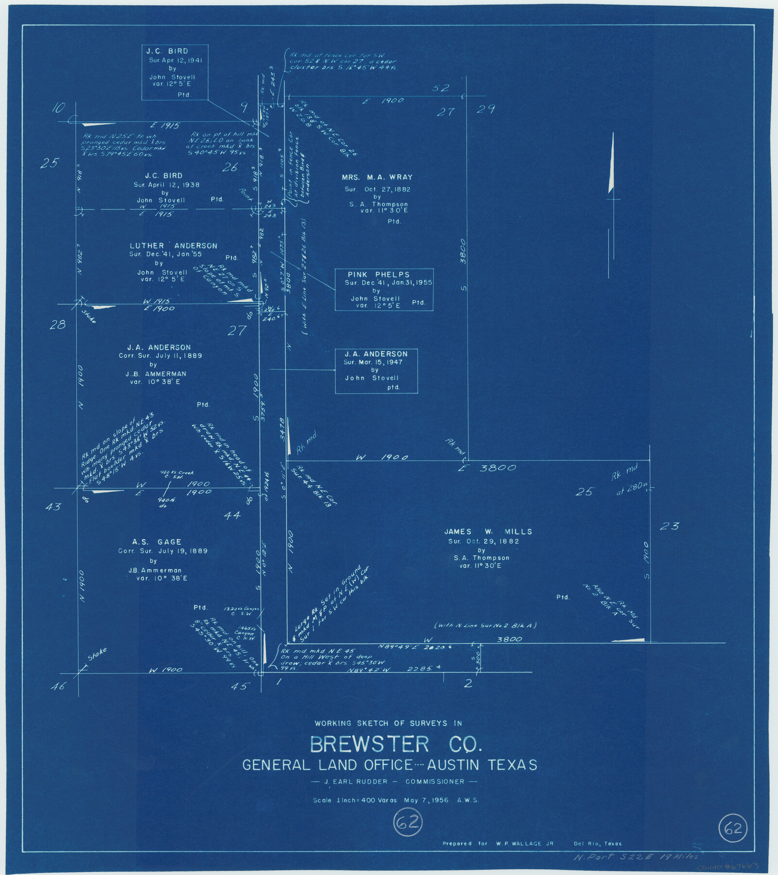
Brewster County Working Sketch 62
-
Map/Doc
67663
-
Collection
General Map Collection
-
Object Dates
5/7/1956 (Creation Date)
-
Counties
Brewster
-
Subjects
Surveying Working Sketch
-
Height x Width
22.7 x 20.2 inches
57.7 x 51.3 cm
-
Scale
1" = 400 varas
Part of: General Map Collection
Map of section no. 10 of a survey of Padre Island made for the Office of the Attorney General of the State of Texas

Print $40.00
- Digital $50.00
Map of section no. 10 of a survey of Padre Island made for the Office of the Attorney General of the State of Texas
1941
Size 57.2 x 40.6 inches
Map/Doc 2266
Throckmorton County Sketch File 5a

Print $22.00
- Digital $50.00
Throckmorton County Sketch File 5a
Size 8.0 x 7.8 inches
Map/Doc 38075
Reeves County Rolled Sketch 35

Print $20.00
- Digital $50.00
Reeves County Rolled Sketch 35
2013
Size 25.3 x 36.8 inches
Map/Doc 93706
Roberts County Working Sketch 26

Print $20.00
- Digital $50.00
Roberts County Working Sketch 26
1982
Size 28.5 x 31.6 inches
Map/Doc 63552
[Galveston, Harrisburg & San Antonio Railroad from Cuero to Stockdale]
![64202, [Galveston, Harrisburg & San Antonio Railroad from Cuero to Stockdale], General Map Collection](https://historictexasmaps.com/wmedia_w700/maps/64202.tif.jpg)
Print $20.00
- Digital $50.00
[Galveston, Harrisburg & San Antonio Railroad from Cuero to Stockdale]
1907
Size 13.3 x 33.1 inches
Map/Doc 64202
Edwards County Rolled Sketch 9

Print $20.00
- Digital $50.00
Edwards County Rolled Sketch 9
1885
Size 29.3 x 42.8 inches
Map/Doc 5802
Williamson County Sketch File 19

Print $24.00
- Digital $50.00
Williamson County Sketch File 19
Size 12.8 x 8.0 inches
Map/Doc 40345
Eastland County Working Sketch 29

Print $20.00
- Digital $50.00
Eastland County Working Sketch 29
1952
Size 21.1 x 22.3 inches
Map/Doc 68810
Texas Gulf Coast, from the Sabine River to the Rio Grande as Subdivided for Mineral Development; Jefferson, Chambers and Galveston Counties

Print $20.00
- Digital $50.00
Texas Gulf Coast, from the Sabine River to the Rio Grande as Subdivided for Mineral Development; Jefferson, Chambers and Galveston Counties
1976
Size 29.0 x 42.5 inches
Map/Doc 1937
Hartley County Sketch File 12

Print $20.00
- Digital $50.00
Hartley County Sketch File 12
1906
Size 16.3 x 12.4 inches
Map/Doc 11736
Van Zandt County Sketch File 39

Print $6.00
- Digital $50.00
Van Zandt County Sketch File 39
1871
Size 10.8 x 13.4 inches
Map/Doc 39484
Edwards County Working Sketch 32

Print $20.00
- Digital $50.00
Edwards County Working Sketch 32
1947
Size 28.9 x 37.7 inches
Map/Doc 68908
You may also like
Flight Mission No. DAG-23K, Frame 152, Matagorda County

Print $20.00
- Digital $50.00
Flight Mission No. DAG-23K, Frame 152, Matagorda County
1953
Size 15.9 x 15.9 inches
Map/Doc 86500
[Blocks W and Z with tie lines]
![90451, [Blocks W and Z with tie lines], Twichell Survey Records](https://historictexasmaps.com/wmedia_w700/maps/90451-1.tif.jpg)
Print $20.00
- Digital $50.00
[Blocks W and Z with tie lines]
1949
Size 14.4 x 14.2 inches
Map/Doc 90451
Medina County Rolled Sketch 4

Print $20.00
- Digital $50.00
Medina County Rolled Sketch 4
1943
Size 20.2 x 26.4 inches
Map/Doc 6740
McCulloch County Rolled Sketch 3

Print $40.00
- Digital $50.00
McCulloch County Rolled Sketch 3
Size 85.5 x 20.8 inches
Map/Doc 9497
Cochran County Sketch File 4

Print $20.00
- Digital $50.00
Cochran County Sketch File 4
1931
Size 24.9 x 22.1 inches
Map/Doc 11100
Wilson County Boundary File 5

Print $20.00
- Digital $50.00
Wilson County Boundary File 5
Size 14.4 x 8.7 inches
Map/Doc 60109
Terrell County Rolled Sketch 41

Print $20.00
- Digital $50.00
Terrell County Rolled Sketch 41
Size 18.6 x 34.3 inches
Map/Doc 9990
[Sketch of part of Blks. 4, 6, B5, 2Z, M6, M8, and M13]
![89643, [Sketch of part of Blks. 4, 6, B5, 2Z, M6, M8, and M13], Twichell Survey Records](https://historictexasmaps.com/wmedia_w700/maps/89643-1.tif.jpg)
Print $40.00
- Digital $50.00
[Sketch of part of Blks. 4, 6, B5, 2Z, M6, M8, and M13]
Size 55.2 x 26.8 inches
Map/Doc 89643
Working Sketch in Bastrop County

Print $20.00
- Digital $50.00
Working Sketch in Bastrop County
1923
Size 18.4 x 14.6 inches
Map/Doc 90203
Flight Mission No. CLL-3N, Frame 11, Willacy County

Print $20.00
- Digital $50.00
Flight Mission No. CLL-3N, Frame 11, Willacy County
1954
Size 18.6 x 22.3 inches
Map/Doc 87077
Cochran County Rolled Sketch 5

Print $20.00
- Digital $50.00
Cochran County Rolled Sketch 5
1949
Size 21.5 x 22.0 inches
Map/Doc 5502
Potter County Sketch File 24

Print $13.00
- Digital $50.00
Potter County Sketch File 24
Size 11.0 x 8.5 inches
Map/Doc 82463