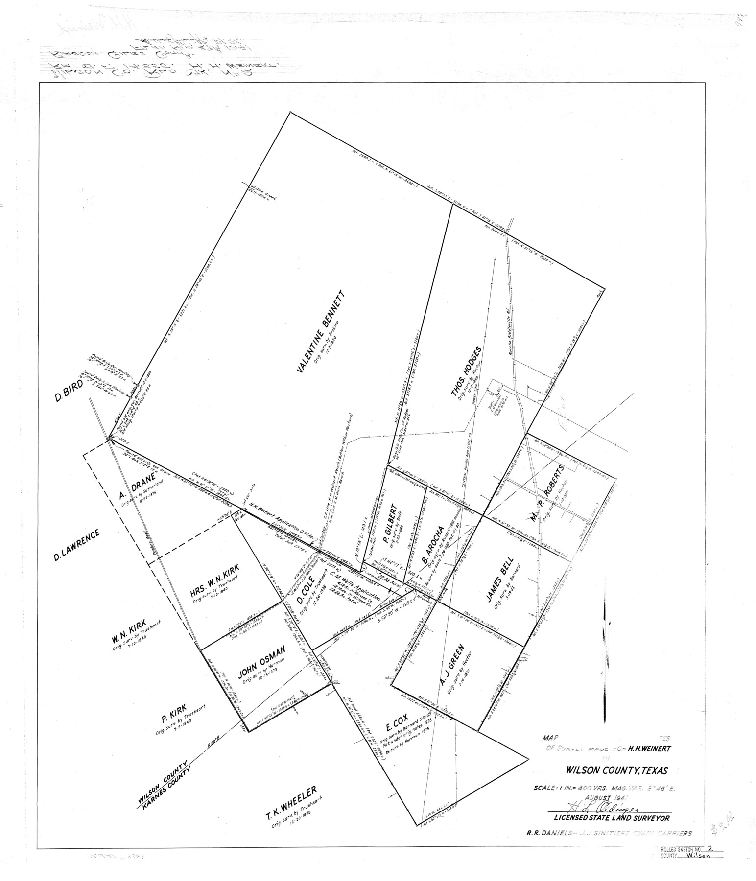
Wilson County Rolled Sketch 2
Map to accompany field notes of survey made for H.H. Weinert in Wilson County, Texas
- 
                          Map/Doc
8368
 - 
                            Collection
General Map Collection
 - 
                            Object Dates
1941 (Creation Date)
1941/8/28 (File Date)
 - 
                            People and Organizations
H.L. Oldinger (Surveyor/Engineer)
R.R. Daniels (Chainman/Field Personnel)
J.J. Sinitiere (Chainman/Field Personnel)
 - 
                            Counties
Wilson Karnes
 - 
                            Subjects
Surveying Rolled Sketch
 - 
                            Height x Width
30.4 x 26.1 inches
77.2 x 66.3 cm
 - 
                            Scale
1" = 400 varas
 
Part of: General Map Collection
            [Galveston, Harrisburg & San Antonio Railroad from Cuero to Stockdale]


                                            Print $20.00                    
                                             -                         Digital $50.00                                    
                [Galveston, Harrisburg & San Antonio Railroad from Cuero to Stockdale]
1907
Size 13.2 x 33.1 inches
                                Map/Doc 64203
            
            A Map of Part of Matagorda Peninsula, State of Texas


                                            Print $40.00                    
                                             -                         Digital $50.00                                    
                A Map of Part of Matagorda Peninsula, State of Texas
1856
Size 34.4 x 54.2 inches
                                Map/Doc 69980
            
            Gulf Coast of the United States, Key West to Rio Grande


                                            Print $20.00                    
                                             -                         Digital $50.00                                    
                Gulf Coast of the United States, Key West to Rio Grande
1863
Size 27.3 x 18.2 inches
                                Map/Doc 72663
            
            Aransas County Rolled Sketch 11


                                            Print $20.00                    
                                             -                         Digital $50.00                                    
                Aransas County Rolled Sketch 11
Size 42.0 x 36.4 inches
                                Map/Doc 8410
            
            Map of DeWitt County


                                            Print $20.00                    
                                             -                         Digital $50.00                                    
                Map of DeWitt County
1853
Size 21.5 x 25.5 inches
                                Map/Doc 3479
            
            Callahan County Working Sketch 6


                                            Print $20.00                    
                                             -                         Digital $50.00                                    
                Callahan County Working Sketch 6
1955
Size 30.2 x 18.8 inches
                                Map/Doc 67888
            
            Henderson County Boundary File 3b


                                            Print $14.00                    
                                             -                         Digital $50.00                                    
                Henderson County Boundary File 3b
Size 14.4 x 8.9 inches
                                Map/Doc 54700
            
            Williamson County Rolled Sketch 11


                                            Print $20.00                    
                                             -                         Digital $50.00                                    
                Williamson County Rolled Sketch 11
Size 37.5 x 28.4 inches
                                Map/Doc 8268
            
            Gillespie County Rolled Sketch O


                                            Print $20.00                    
                                             -                         Digital $50.00                                    
                Gillespie County Rolled Sketch O
1846
Size 42.6 x 20.0 inches
                                Map/Doc 6007
            
            Polk County Sketch File 6


                                            Print $4.00                    
                                             -                         Digital $50.00                                    
                Polk County Sketch File 6
Size 7.1 x 9.4 inches
                                Map/Doc 34129
            
            Chambers County NRC Article 33.136 Sketch 11


                                            Print $28.00                    
                                             -                         Digital $50.00                                    
                Chambers County NRC Article 33.136 Sketch 11
2014
Size 24.0 x 36.0 inches
                                Map/Doc 94740
            You may also like
            Hunt County Boundary File 10a


                                            Print $40.00                    
                                             -                         Digital $50.00                                    
                Hunt County Boundary File 10a
Size 42.1 x 10.5 inches
                                Map/Doc 55262
            
            The Republic County of Jefferson. January 20, 1841


                                            Print $20.00                    
                                    
                The Republic County of Jefferson. January 20, 1841
2020
Size 22.6 x 21.7 inches
                                Map/Doc 96198
            
            University Land Field Notes for Blocks A, B, C, D, E, F, G, H, I, and J in Hudspeth County


            University Land Field Notes for Blocks A, B, C, D, E, F, G, H, I, and J in Hudspeth County
Map/Doc 81712
            
            Lee County Working Sketch 16


                                            Print $20.00                    
                                             -                         Digital $50.00                                    
                Lee County Working Sketch 16
1982
Size 20.5 x 13.5 inches
                                Map/Doc 70395
            
            [Sketch Showing Blocks O18, P Mc, B10 and B11]


                                            Print $3.00                    
                                             -                         Digital $50.00                                    
                [Sketch Showing Blocks O18, P Mc, B10 and B11]
Size 11.1 x 11.1 inches
                                Map/Doc 93105
            
            College Heights a Subdivision of Outlots 8-9 and 62, Division B, Austin, Texas


                                            Print $20.00                    
                                             -                         Digital $50.00                                    
                College Heights a Subdivision of Outlots 8-9 and 62, Division B, Austin, Texas
Size 18.5 x 14.9 inches
                                Map/Doc 5055
            
            Matagorda County Sketch File 24


                                            Print $10.00                    
                                             -                         Digital $50.00                                    
                Matagorda County Sketch File 24
1900
Size 8.2 x 5.1 inches
                                Map/Doc 30787
            
            Land grants from the state of Tamaulipas in the trans-Nueces


            Land grants from the state of Tamaulipas in the trans-Nueces
2009
Size 11.0 x 8.5 inches
                                Map/Doc 94040
            
            Crosby County Sketch File 18


                                            Print $26.00                    
                                             -                         Digital $50.00                                    
                Crosby County Sketch File 18
1905
Size 14.2 x 8.5 inches
                                Map/Doc 20071
            
            Fort Bend County Sketch File 21


                                            Print $4.00                    
                                             -                         Digital $50.00                                    
                Fort Bend County Sketch File 21
1882
Size 8.8 x 13.4 inches
                                Map/Doc 22954
            
            Flight Mission No. BQR-14K, Frame 36, Brazoria County


                                            Print $20.00                    
                                             -                         Digital $50.00                                    
                Flight Mission No. BQR-14K, Frame 36, Brazoria County
1952
Size 18.6 x 22.3 inches
                                Map/Doc 84093
            
            Travis County Appraisal District Plat Map 2_0805


                                            Print $20.00                    
                                             -                         Digital $50.00                                    
                Travis County Appraisal District Plat Map 2_0805
Size 21.4 x 26.4 inches
                                Map/Doc 94231