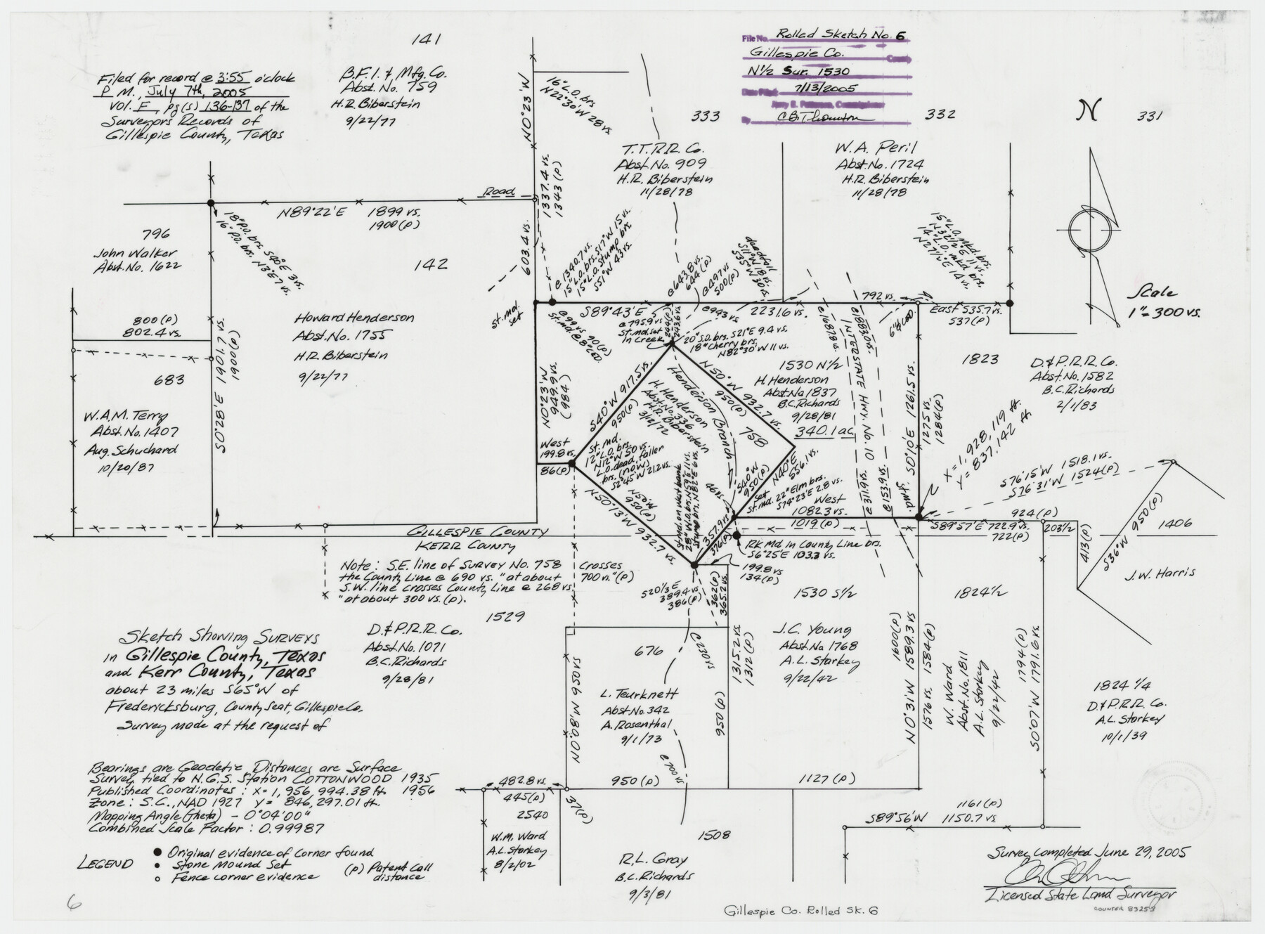
Gillespie County Rolled Sketch 6
Sketch showing surveys in Gillespie County, Texas and Kerr County, Texas about 23 miles S 65° W of Fredericksburg, county seat, Gillespie Co.
-
Map/Doc
83253
-
Collection
General Map Collection
-
Object Dates
2005/6/29 (Creation Date)
2005/7/13 (File Date)
-
People and Organizations
Charles Ottmers (Surveyor/Engineer)
-
Counties
Gillespie Kerr
-
Subjects
Surveying Rolled Sketch
-
Height x Width
18.2 x 24.6 inches
46.2 x 62.5 cm
-
Medium
mylar, print
-
Scale
1" = 300 varas
Part of: General Map Collection
San Augustine County Rolled Sketch 1

Print $20.00
- Digital $50.00
San Augustine County Rolled Sketch 1
1946
Size 19.1 x 30.4 inches
Map/Doc 7553
Calhoun County Working Sketch 5

Print $40.00
- Digital $50.00
Calhoun County Working Sketch 5
1941
Size 23.7 x 125.2 inches
Map/Doc 67821
Hill County Sketch File 27

Print $4.00
- Digital $50.00
Hill County Sketch File 27
1873
Size 10.4 x 8.2 inches
Map/Doc 26528
[Surveys along the Salado and Lampasas Rivers and Saltillo Creek]
![82159, [Surveys along the Salado and Lampasas Rivers and Saltillo Creek], General Map Collection](https://historictexasmaps.com/wmedia_w700/maps/82159.tif.jpg)
Print $2.00
- Digital $50.00
[Surveys along the Salado and Lampasas Rivers and Saltillo Creek]
1845
Size 13.1 x 7.7 inches
Map/Doc 82159
Harris County Working Sketch 43

Print $20.00
- Digital $50.00
Harris County Working Sketch 43
1940
Size 26.8 x 22.1 inches
Map/Doc 65935
Map of San Jacinto County
Print $20.00
- Digital $50.00
Map of San Jacinto County
1889
Size 43.8 x 37.0 inches
Map/Doc 16808
Map of Childress, Childress County, Texas on the Line of the Fort Worth and Denver City Railway, Texas Pan-Handle Route

Print $20.00
- Digital $50.00
Map of Childress, Childress County, Texas on the Line of the Fort Worth and Denver City Railway, Texas Pan-Handle Route
1888
Size 35.6 x 28.0 inches
Map/Doc 7691
Flight Mission No. DAG-22K, Frame 82, Matagorda County

Print $20.00
- Digital $50.00
Flight Mission No. DAG-22K, Frame 82, Matagorda County
1953
Size 18.5 x 22.4 inches
Map/Doc 86466
[Beaumont, Sour Lake and Western Ry. Right of Way and Alignment - Frisco]
![64128, [Beaumont, Sour Lake and Western Ry. Right of Way and Alignment - Frisco], General Map Collection](https://historictexasmaps.com/wmedia_w700/maps/64128.tif.jpg)
Print $20.00
- Digital $50.00
[Beaumont, Sour Lake and Western Ry. Right of Way and Alignment - Frisco]
1910
Size 20.1 x 45.9 inches
Map/Doc 64128
Flight Mission No. CGI-3N, Frame 109, Cameron County

Print $20.00
- Digital $50.00
Flight Mission No. CGI-3N, Frame 109, Cameron County
1954
Size 18.5 x 22.1 inches
Map/Doc 84589
Sutton County Sketch File 22

Print $4.00
- Digital $50.00
Sutton County Sketch File 22
Size 14.2 x 8.5 inches
Map/Doc 37459
Comal County Working Sketch 3

Print $20.00
- Digital $50.00
Comal County Working Sketch 3
1944
Size 31.1 x 27.9 inches
Map/Doc 68169
You may also like
Flight Mission No. DQN-6K, Frame 69, Calhoun County

Print $20.00
- Digital $50.00
Flight Mission No. DQN-6K, Frame 69, Calhoun County
1953
Size 18.6 x 22.1 inches
Map/Doc 84441
Panola County Sketch File 25

Print $20.00
- Digital $50.00
Panola County Sketch File 25
1946
Size 24.1 x 21.4 inches
Map/Doc 12140
Jefferson County Sketch File 44

Print $20.00
- Digital $50.00
Jefferson County Sketch File 44
1917
Size 22.8 x 32.9 inches
Map/Doc 11878
[Blocks GM, and D3 and Vicinity in Motley and Floyd Counties]
![91502, [Blocks GM, and D3 and Vicinity in Motley and Floyd Counties], Twichell Survey Records](https://historictexasmaps.com/wmedia_w700/maps/91502-1.tif.jpg)
Print $20.00
- Digital $50.00
[Blocks GM, and D3 and Vicinity in Motley and Floyd Counties]
1904
Size 23.8 x 17.4 inches
Map/Doc 91502
Sherman County

Print $20.00
- Digital $50.00
Sherman County
1889
Size 22.3 x 19.0 inches
Map/Doc 4036
McCulloch County Sketch File 6

Print $20.00
- Digital $50.00
McCulloch County Sketch File 6
1893
Size 44.2 x 19.3 inches
Map/Doc 10539
Current Miscellaneous File 54

Print $24.00
- Digital $50.00
Current Miscellaneous File 54
1955
Size 11.2 x 8.7 inches
Map/Doc 74042
Flight Mission No. CLL-1N, Frame 194, Willacy County

Print $20.00
- Digital $50.00
Flight Mission No. CLL-1N, Frame 194, Willacy County
1954
Size 18.5 x 22.1 inches
Map/Doc 87064
General Highway Map, Kenedy County, Texas

Print $20.00
General Highway Map, Kenedy County, Texas
1940
Size 18.5 x 24.9 inches
Map/Doc 79154
Upton County Sketch File 2

Print $40.00
- Digital $50.00
Upton County Sketch File 2
Size 38.5 x 55.4 inches
Map/Doc 10413
Newton County Sketch File 48

Print $4.00
- Digital $50.00
Newton County Sketch File 48
Size 12.4 x 7.9 inches
Map/Doc 32460
Map of Location of the Pecos & Northern Texas Railway from Station 5868+52 to Station 7879+36 = 38.08 Miles through Parmer County, Texas

Print $40.00
- Digital $50.00
Map of Location of the Pecos & Northern Texas Railway from Station 5868+52 to Station 7879+36 = 38.08 Miles through Parmer County, Texas
Size 20.2 x 108.5 inches
Map/Doc 64090