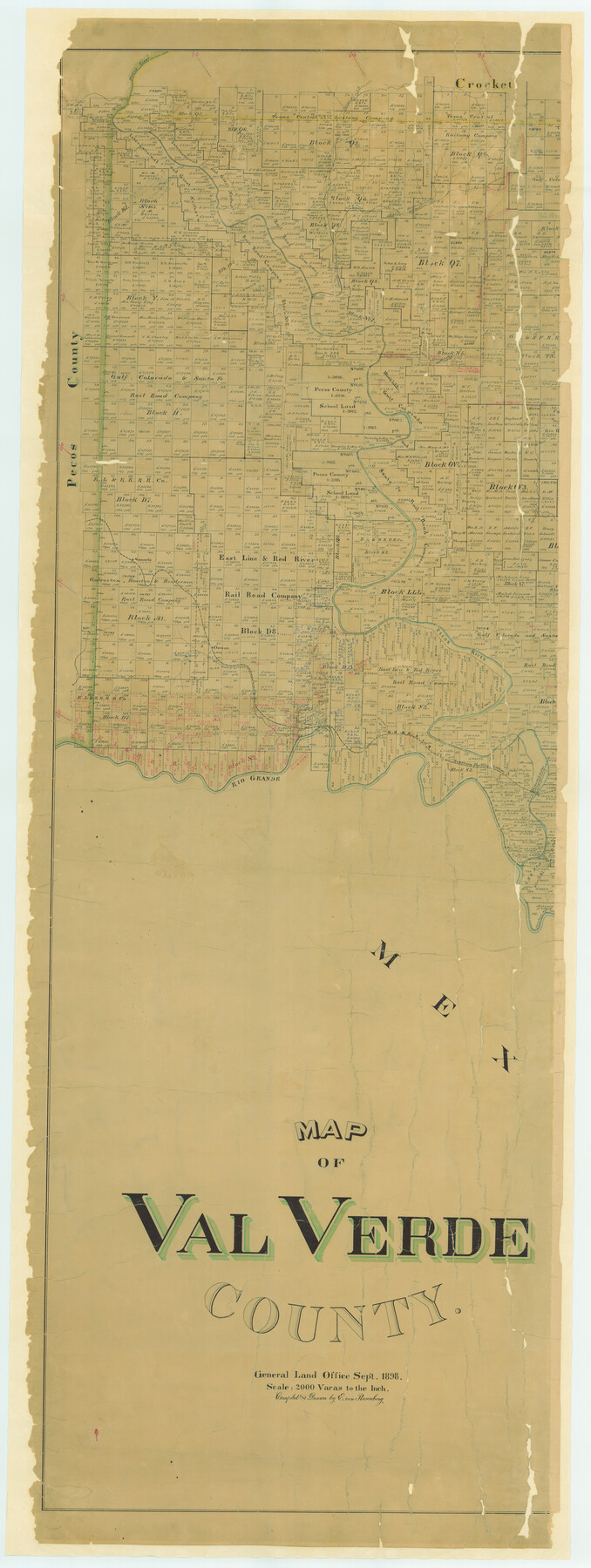
Map of Val Verde County
-
Map/Doc
82013
-
Collection
General Map Collection
-
Object Dates
1898 (Creation Date)
-
People and Organizations
Texas General Land Office (Publisher)
E. von Rosenberg (Draftsman)
E. von Rosenberg (Compiler)
-
Counties
Val Verde
-
Subjects
County
-
Height x Width
81.6 x 30.7 inches
207.3 x 78.0 cm
-
Comments
See counter 82013 for west part. See counter 82014 for digitally combined image.
Conservation funded in 2004 with donation from Glen Sample Ely. -
Features
Oppenheimer Spring
GH&SA Bridge
Rio Grande
Southern Pacific Railroad Company
GH&SA
Langtry
Cañon Grande
R&M Ranch
Willow Spring
Osman
Fielders Ranch
Lewis Cañon
Colorado River
Old Camp Shafter
Old Mouth of Howard's Creek
Fielder's Creek
Col. Shafters Trail
Indian Trail
Howards Creek
Geddis Spring
Pecos River
Abandoned Railroad
Pecos River
Samuels
Part of: General Map Collection
Val Verde County Rolled Sketch 66

Print $40.00
- Digital $50.00
Val Verde County Rolled Sketch 66
1957
Size 30.7 x 55.0 inches
Map/Doc 10084
Texas, Copano Bay, Mission Bay and Fish Point

Print $40.00
- Digital $50.00
Texas, Copano Bay, Mission Bay and Fish Point
1934
Size 33.3 x 48.9 inches
Map/Doc 73433
Flight Mission No. CRC-3R, Frame 206, Chambers County

Print $20.00
- Digital $50.00
Flight Mission No. CRC-3R, Frame 206, Chambers County
1956
Size 18.5 x 22.2 inches
Map/Doc 84861
Winkler County Working Sketch 5

Print $40.00
- Digital $50.00
Winkler County Working Sketch 5
1957
Size 31.1 x 131.9 inches
Map/Doc 72599
Garza County Rolled Sketch J

Print $20.00
- Digital $50.00
Garza County Rolled Sketch J
1911
Size 27.2 x 23.4 inches
Map/Doc 6004
Refugio County Rolled Sketch 8

Print $40.00
- Digital $50.00
Refugio County Rolled Sketch 8
1954
Size 53.9 x 46.7 inches
Map/Doc 9860
[Surveys along the Sabine River made under G.W. Smyth, Commissioner]
![89, [Surveys along the Sabine River made under G.W. Smyth, Commissioner], General Map Collection](https://historictexasmaps.com/wmedia_w700/maps/89.tif.jpg)
Print $20.00
- Digital $50.00
[Surveys along the Sabine River made under G.W. Smyth, Commissioner]
Size 12.6 x 17.1 inches
Map/Doc 89
Jefferson County Sketch File 41

Print $58.00
- Digital $50.00
Jefferson County Sketch File 41
1957
Size 14.2 x 8.7 inches
Map/Doc 28236
South Part Brewster Co.

Print $40.00
- Digital $50.00
South Part Brewster Co.
Size 36.5 x 51.5 inches
Map/Doc 66723
Chambers County Working Sketch 12

Print $20.00
- Digital $50.00
Chambers County Working Sketch 12
1954
Size 35.2 x 33.8 inches
Map/Doc 67995
Webb County Sketch File 14-1

Print $6.00
- Digital $50.00
Webb County Sketch File 14-1
1892
Size 14.4 x 9.1 inches
Map/Doc 39814
Map of Liberty County Texas

Print $20.00
- Digital $50.00
Map of Liberty County Texas
1895
Size 29.7 x 29.4 inches
Map/Doc 3811
You may also like
Caldwell County Sketch File 4a

Print $8.00
- Digital $50.00
Caldwell County Sketch File 4a
1898
Size 11.2 x 8.8 inches
Map/Doc 35835
Flight Mission No. DQO-3K, Frame 15, Galveston County

Print $20.00
- Digital $50.00
Flight Mission No. DQO-3K, Frame 15, Galveston County
1952
Size 18.7 x 22.4 inches
Map/Doc 85056
General Highway Map, Borden County, Texas

Print $20.00
General Highway Map, Borden County, Texas
1961
Size 18.3 x 25.0 inches
Map/Doc 79377
Hays County Sketch File 16

Print $4.00
- Digital $50.00
Hays County Sketch File 16
1857
Size 12.8 x 8.3 inches
Map/Doc 26227
Concho County Sketch File 50

Print $20.00
- Digital $50.00
Concho County Sketch File 50
1890
Size 15.9 x 13.6 inches
Map/Doc 19217

Coleman County Working Sketch 13
Print $20.00
- Digital $50.00
Coleman County Working Sketch 13
1952
Size 37.1 x 26.3 inches
Map/Doc 68079
[Wm. Baker and Chas. Lydings surveys and vicinity]
![92988, [Wm. Baker and Chas. Lydings surveys and vicinity], Twichell Survey Records](https://historictexasmaps.com/wmedia_w700/maps/92988-1.tif.jpg)
Print $2.00
- Digital $50.00
[Wm. Baker and Chas. Lydings surveys and vicinity]
Size 6.6 x 7.0 inches
Map/Doc 92988
From Citizens of Montgomery County for the Creation of a New County to be Called Bowie, January 18, 1838

Print $20.00
From Citizens of Montgomery County for the Creation of a New County to be Called Bowie, January 18, 1838
2020
Size 19.1 x 21.7 inches
Map/Doc 96376
Orange County Rolled Sketch 31

Print $40.00
- Digital $50.00
Orange County Rolled Sketch 31
1926
Size 88.7 x 35.2 inches
Map/Doc 9651
Potter County

Print $20.00
- Digital $50.00
Potter County
1960
Size 42.6 x 34.6 inches
Map/Doc 66985
Presidio County Rolled Sketch 102

Print $20.00
- Digital $50.00
Presidio County Rolled Sketch 102
1957
Size 22.8 x 17.4 inches
Map/Doc 7384