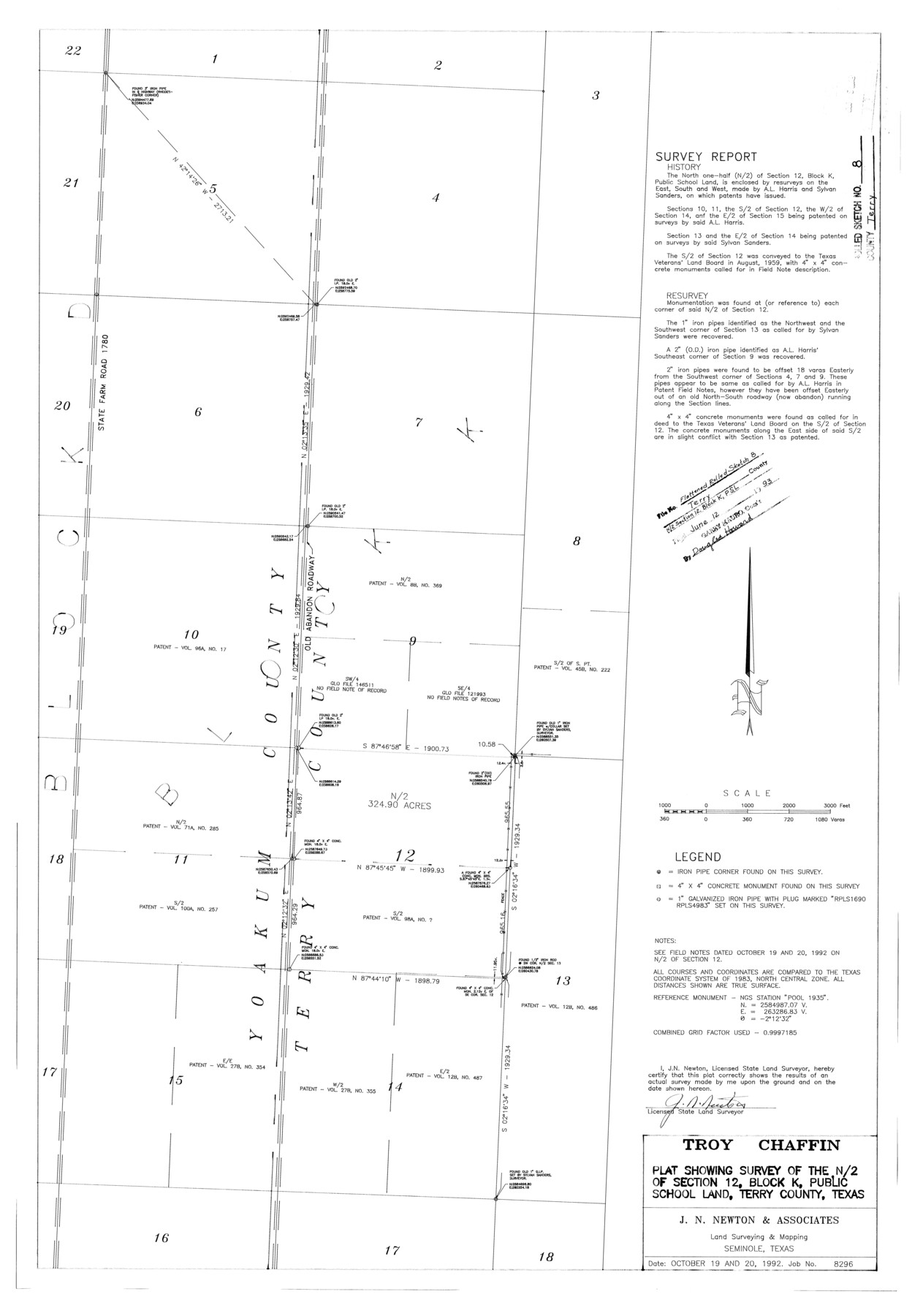
Terry County Rolled Sketch 8
Troy Chaffin - plat showing survey of the N/2 of section 12, Block K, Public School Land, Terry County, Texas
-
Map/Doc
7982
-
Collection
General Map Collection
-
Object Dates
1992/10/20 (Survey Date)
1993/6/12 (File Date)
-
People and Organizations
J.N. Newton (Surveyor/Engineer)
-
Counties
Terry Yoakum
-
Subjects
Surveying Rolled Sketch
-
Height x Width
31.7 x 22.3 inches
80.5 x 56.6 cm
-
Medium
mylar, print
Part of: General Map Collection
Presidio County Rolled Sketch 78

Print $20.00
- Digital $50.00
Presidio County Rolled Sketch 78
1941
Size 32.4 x 39.2 inches
Map/Doc 7364
Parker County Sketch File 2

Print $4.00
- Digital $50.00
Parker County Sketch File 2
1856
Size 12.7 x 8.2 inches
Map/Doc 33519
Montgomery County Sketch File 14

Print $42.00
- Digital $50.00
Montgomery County Sketch File 14
1905
Size 11.0 x 8.8 inches
Map/Doc 31805
Crockett County Working Sketch Graphic Index - northwest part - sheet A

Print $40.00
- Digital $50.00
Crockett County Working Sketch Graphic Index - northwest part - sheet A
1983
Size 37.0 x 48.2 inches
Map/Doc 76509
Ward County Rolled Sketch 1

Print $40.00
- Digital $50.00
Ward County Rolled Sketch 1
1888
Size 42.6 x 120.4 inches
Map/Doc 76165
[Galveston, Harrisburg & San Antonio Railroad from Cuero to Stockdale]
![64185, [Galveston, Harrisburg & San Antonio Railroad from Cuero to Stockdale], General Map Collection](https://historictexasmaps.com/wmedia_w700/maps/64185.tif.jpg)
Print $20.00
- Digital $50.00
[Galveston, Harrisburg & San Antonio Railroad from Cuero to Stockdale]
1906
Size 13.6 x 34.0 inches
Map/Doc 64185
Williamson County Rolled Sketch 5

Print $20.00
- Digital $50.00
Williamson County Rolled Sketch 5
1940
Size 23.7 x 34.5 inches
Map/Doc 8263
Archer County Sketch File 19

Print $40.00
- Digital $50.00
Archer County Sketch File 19
1902
Size 23.8 x 26.8 inches
Map/Doc 10829
Brazoria County Rolled Sketch 21A

Print $20.00
- Digital $50.00
Brazoria County Rolled Sketch 21A
Size 38.6 x 33.2 inches
Map/Doc 8926
Flight Mission No. BRE-2P, Frame 70, Nueces County

Print $20.00
- Digital $50.00
Flight Mission No. BRE-2P, Frame 70, Nueces County
1956
Size 18.5 x 22.6 inches
Map/Doc 86765
Montgomery County Working Sketch 6

Print $20.00
- Digital $50.00
Montgomery County Working Sketch 6
1932
Size 24.8 x 32.2 inches
Map/Doc 71112
Floyd County Sketch File 14

Print $10.00
- Digital $50.00
Floyd County Sketch File 14
1913
Size 11.3 x 8.7 inches
Map/Doc 22731
You may also like
Robertson & Scott V Ranch situated in Crosby County, Texas

Print $40.00
- Digital $50.00
Robertson & Scott V Ranch situated in Crosby County, Texas
Size 41.2 x 48.8 inches
Map/Doc 89758
Donley County Sketch File 1

Print $6.00
- Digital $50.00
Donley County Sketch File 1
Size 8.2 x 6.5 inches
Map/Doc 21214
Taylor County Working Sketch 12

Print $20.00
- Digital $50.00
Taylor County Working Sketch 12
1956
Size 25.5 x 26.9 inches
Map/Doc 69622
Flight Mission No. BRE-1P, Frame 46, Nueces County

Print $20.00
- Digital $50.00
Flight Mission No. BRE-1P, Frame 46, Nueces County
1956
Size 16.4 x 16.2 inches
Map/Doc 86635
Menard County Working Sketch 20

Print $20.00
- Digital $50.00
Menard County Working Sketch 20
1947
Size 38.5 x 34.9 inches
Map/Doc 70967
Real County Sketch File 7

Print $8.00
- Digital $50.00
Real County Sketch File 7
1931
Size 11.3 x 8.8 inches
Map/Doc 35055
[Blocks C41, C42, A1, and vicinity]
![92641, [Blocks C41, C42, A1, and vicinity], Twichell Survey Records](https://historictexasmaps.com/wmedia_w700/maps/92641-1.tif.jpg)
Print $20.00
- Digital $50.00
[Blocks C41, C42, A1, and vicinity]
Size 15.7 x 43.3 inches
Map/Doc 92641
Concho County

Print $20.00
- Digital $50.00
Concho County
1897
Size 45.9 x 38.0 inches
Map/Doc 66785
Harris County Boundary File 2

Print $8.00
- Digital $50.00
Harris County Boundary File 2
Size 8.1 x 8.7 inches
Map/Doc 54294
Roberts County Working Sketch 38

Print $20.00
- Digital $50.00
Roberts County Working Sketch 38
1978
Size 26.7 x 22.5 inches
Map/Doc 63564
Atascosa County Sketch File 28

Print $40.00
- Digital $50.00
Atascosa County Sketch File 28
1878
Size 27.9 x 21.7 inches
Map/Doc 10862
[Northwest Garza County around John Walker and Thomas Hughes surveys]
![90906, [Northwest Garza County around John Walker and Thomas Hughes surveys], Twichell Survey Records](https://historictexasmaps.com/wmedia_w700/maps/90906-1.tif.jpg)
Print $20.00
- Digital $50.00
[Northwest Garza County around John Walker and Thomas Hughes surveys]
1913
Size 28.3 x 14.5 inches
Map/Doc 90906