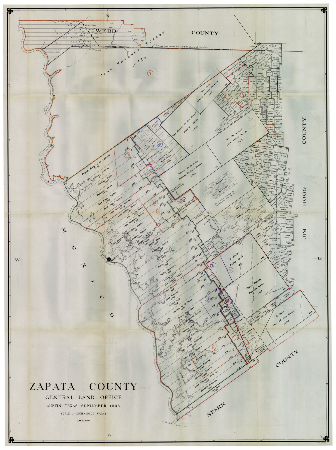
Zapata County Working Sketch Graphic Index, Sheet 1 (Sketches 1 to 18)
- 
                          Map/Doc
76749
 - 
                            Collection
General Map Collection
 - 
                            Object Dates
9/1935 (Creation Date)
 - 
                            People and Organizations
J.O. Barrow (Draftsman)
 - 
                            Counties
Zapata
 - 
                            Subjects
County Surveying Working Sketch
 - 
                            Height x Width
55.3 x 41.3 inches
140.5 x 104.9 cm
 - 
                            Scale
1" = 2000 varas
 
Part of: General Map Collection
            Jefferson County Working Sketch 32


                                            Print $40.00                    
                                             -                         Digital $50.00                                    
                Jefferson County Working Sketch 32
1981
Size 68.9 x 36.0 inches
                                Map/Doc 66576
            
            Baylor County Working Sketch 7


                                            Print $20.00                    
                                             -                         Digital $50.00                                    
                Baylor County Working Sketch 7
1950
Size 31.4 x 24.0 inches
                                Map/Doc 67292
            
            San Patricio County NRC Article 33.136 Sketch 6


                                            Print $24.00                    
                                             -                         Digital $50.00                                    
                San Patricio County NRC Article 33.136 Sketch 6
2010
Size 22.0 x 34.0 inches
                                Map/Doc 94472
            
            [Surveys along the Salado and Lampasas Rivers and Saltillo Creek]


                                            Print $2.00                    
                                             -                         Digital $50.00                                    
                [Surveys along the Salado and Lampasas Rivers and Saltillo Creek]
1845
Size 13.1 x 7.8 inches
                                Map/Doc 362
            
            Titus County Working Sketch Graphic Index


                                            Print $20.00                    
                                             -                         Digital $50.00                                    
                Titus County Working Sketch Graphic Index
1948
Size 40.2 x 29.0 inches
                                Map/Doc 76714
            
            Dallas County Sketch File 10


                                            Print $4.00                    
                                             -                         Digital $50.00                                    
                Dallas County Sketch File 10
1858
Size 12.5 x 8.2 inches
                                Map/Doc 20414
            
            Harris County Rolled Sketch 85


                                            Print $20.00                    
                                             -                         Digital $50.00                                    
                Harris County Rolled Sketch 85
1968
Size 22.0 x 32.0 inches
                                Map/Doc 6119
            
            Gonzales County Rolled Sketch 3


                                            Print $20.00                    
                                             -                         Digital $50.00                                    
                Gonzales County Rolled Sketch 3
2021
Size 24.4 x 35.6 inches
                                Map/Doc 96582
            
            El Paso County Sketch File 16


                                            Print $20.00                    
                                             -                         Digital $50.00                                    
                El Paso County Sketch File 16
1885
Size 31.0 x 36.0 inches
                                Map/Doc 10446
            
            Fort Bend County Sketch File 27


                                            Print $20.00                    
                                             -                         Digital $50.00                                    
                Fort Bend County Sketch File 27
1910
Size 17.9 x 37.7 inches
                                Map/Doc 10453
            
            Map of Grayson County


                                            Print $20.00                    
                                             -                         Digital $50.00                                    
                Map of Grayson County
1871
Size 19.5 x 17.8 inches
                                Map/Doc 1088
            You may also like
            Map of Wilson County


                                            Print $20.00                    
                                             -                         Digital $50.00                                    
                Map of Wilson County
1840
Size 24.4 x 21.0 inches
                                Map/Doc 4154
            
            Cherokee County Sketch File 9


                                            Print $8.00                    
                                             -                         Digital $50.00                                    
                Cherokee County Sketch File 9
1853
Size 5.6 x 4.2 inches
                                Map/Doc 18132
            
            Sectional map of Texas traversed by the Missouri, Kansas & Texas Railway, showing the crops adapted to each section, with the elevation and annual rainfall


                                            Print $20.00                    
                                             -                         Digital $50.00                                    
                Sectional map of Texas traversed by the Missouri, Kansas & Texas Railway, showing the crops adapted to each section, with the elevation and annual rainfall
1904
Size 21.7 x 22.6 inches
                                Map/Doc 95814
            
            [T.&P. Blocks 57 and 58, South to PSL Block 53]


                                            Print $40.00                    
                                             -                         Digital $50.00                                    
                [T.&P. Blocks 57 and 58, South to PSL Block 53]
Size 30.5 x 68.7 inches
                                Map/Doc 89763
            
            Sketch, Val Verde County, Part of Blk. D-7 E. L. & R. R. Ry., Survey for Mrs. Geo. Baker, P. Bradford et. al.


                                            Print $20.00                    
                                             -                         Digital $50.00                                    
                Sketch, Val Verde County, Part of Blk. D-7 E. L. & R. R. Ry., Survey for Mrs. Geo. Baker, P. Bradford et. al.
1937
Size 18.2 x 16.2 inches
                                Map/Doc 91873
            
            Flight Mission No. CGI-3N, Frame 180, Cameron County


                                            Print $20.00                    
                                             -                         Digital $50.00                                    
                Flight Mission No. CGI-3N, Frame 180, Cameron County
1954
Size 18.6 x 22.2 inches
                                Map/Doc 84644
            
            Ector County Working Sketch 31


                                            Print $40.00                    
                                             -                         Digital $50.00                                    
                Ector County Working Sketch 31
1980
Size 36.0 x 51.0 inches
                                Map/Doc 68874
            
            Val Verde County Sketch File 40


                                            Print $20.00                    
                                             -                         Digital $50.00                                    
                Val Verde County Sketch File 40
1939
Size 15.3 x 25.5 inches
                                Map/Doc 12582
            
            Flight Mission No. CZW-1R, Frame 165, Hardeman County


                                            Print $20.00                    
                                             -                         Digital $50.00                                    
                Flight Mission No. CZW-1R, Frame 165, Hardeman County
1956
Size 18.7 x 22.4 inches
                                Map/Doc 85236
            
            Throckmorton County Rolled Sketch 3C


                                            Print $20.00                    
                                             -                         Digital $50.00                                    
                Throckmorton County Rolled Sketch 3C
Size 31.1 x 37.1 inches
                                Map/Doc 7989
            
            Brewster County Working Sketch 38


                                            Print $20.00                    
                                             -                         Digital $50.00                                    
                Brewster County Working Sketch 38
1944
Size 36.3 x 28.4 inches
                                Map/Doc 67572
            
            No. 3 Chart of Channel connecting Corpus Christi Bay with Aransas Bay, Texas


                                            Print $20.00                    
                                             -                         Digital $50.00                                    
                No. 3 Chart of Channel connecting Corpus Christi Bay with Aransas Bay, Texas
1878
Size 18.3 x 27.9 inches
                                Map/Doc 72783