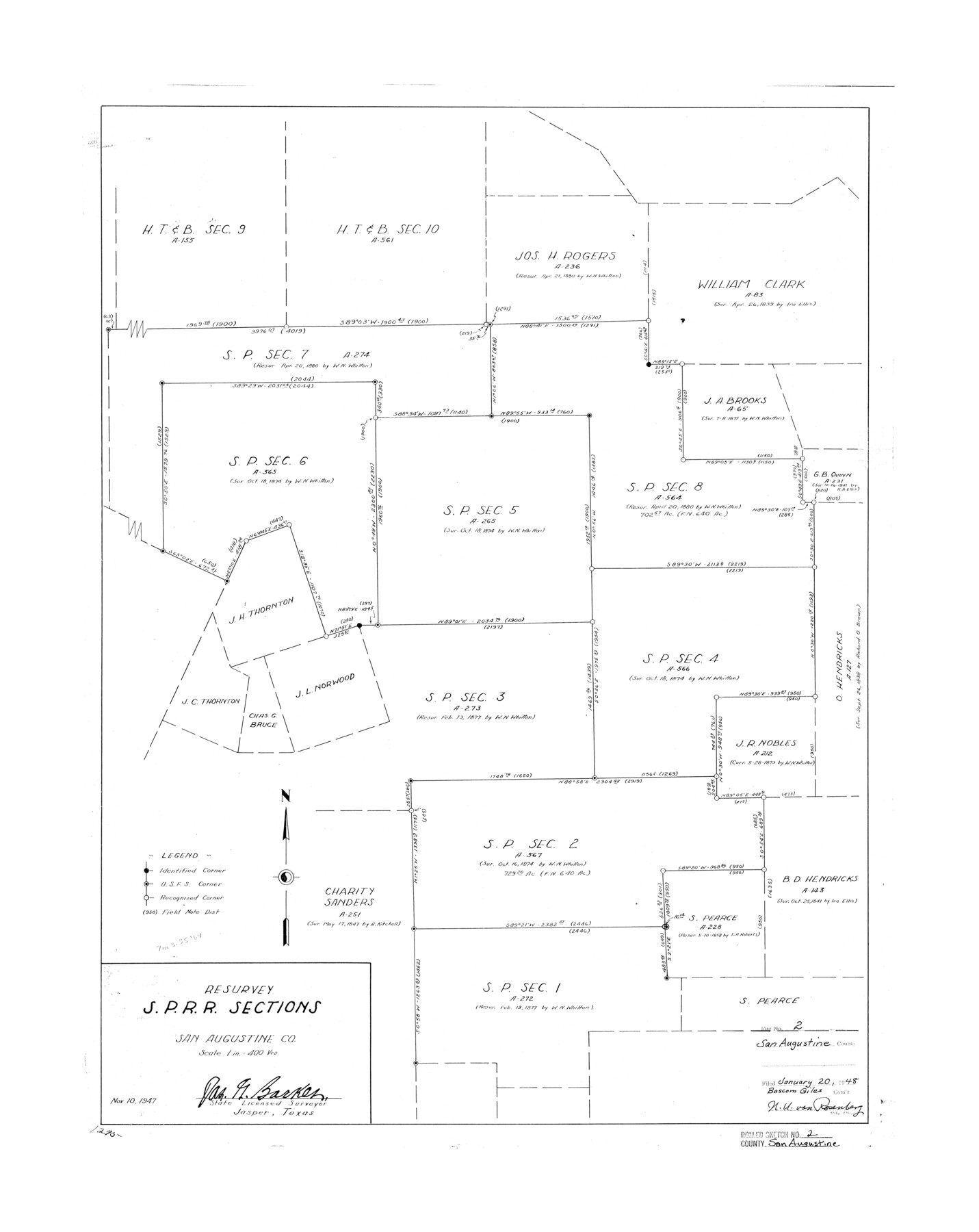
San Augustine County Rolled Sketch 2
Resurvey S. P. R.R. sections
-
Map/Doc
7554
-
Collection
General Map Collection
-
Object Dates
1947/11/10 (Creation Date)
1948/1/20 (File Date)
-
People and Organizations
Jas. G. Barker (Surveyor/Engineer)
-
Counties
San Augustine
-
Subjects
Surveying Rolled Sketch
-
Height x Width
29.1 x 23.1 inches
73.9 x 58.7 cm
-
Scale
1" = 400 varas
Part of: General Map Collection
Sabine Pass and mouth of the River Sabine in the sea

Print $20.00
- Digital $50.00
Sabine Pass and mouth of the River Sabine in the sea
1840
Size 23.8 x 19.0 inches
Map/Doc 94268
Trinity River, Daugherty Lake Sheet/East Fork of Trinity River

Print $20.00
- Digital $50.00
Trinity River, Daugherty Lake Sheet/East Fork of Trinity River
1920
Size 41.9 x 30.1 inches
Map/Doc 65191
Erath County Sketch File 2

Print $20.00
- Digital $50.00
Erath County Sketch File 2
Size 13.2 x 15.5 inches
Map/Doc 11463
Jim Wells County Working Sketch 12

Print $20.00
- Digital $50.00
Jim Wells County Working Sketch 12
1962
Size 19.2 x 15.6 inches
Map/Doc 66610
Maps of Gulf Intracoastal Waterway, Texas - Sabine River to the Rio Grande and connecting waterways including ship channels

Print $20.00
- Digital $50.00
Maps of Gulf Intracoastal Waterway, Texas - Sabine River to the Rio Grande and connecting waterways including ship channels
1966
Size 14.5 x 21.2 inches
Map/Doc 61989
Martin County Sketch File 13

Print $4.00
- Digital $50.00
Martin County Sketch File 13
1941
Size 14.2 x 9.1 inches
Map/Doc 30669
Red River County Sketch File 5

Print $4.00
- Digital $50.00
Red River County Sketch File 5
Size 7.9 x 4.8 inches
Map/Doc 35102
Jeff Davis County Working Sketch 23

Print $20.00
- Digital $50.00
Jeff Davis County Working Sketch 23
1958
Size 41.5 x 30.7 inches
Map/Doc 66518
Galveston County NRC Article 33.136 Location Key Sheet

Print $20.00
- Digital $50.00
Galveston County NRC Article 33.136 Location Key Sheet
1994
Size 27.0 x 21.8 inches
Map/Doc 77016
Hudspeth County Working Sketch 3

Print $20.00
- Digital $50.00
Hudspeth County Working Sketch 3
1913
Size 20.4 x 17.2 inches
Map/Doc 66284
Flight Mission No. DQO-8K, Frame 20, Galveston County

Print $20.00
- Digital $50.00
Flight Mission No. DQO-8K, Frame 20, Galveston County
1952
Size 18.8 x 22.3 inches
Map/Doc 85143
Map of Llano County

Print $20.00
- Digital $50.00
Map of Llano County
1871
Size 17.0 x 20.5 inches
Map/Doc 3825
You may also like
Harris County Sketch File 23a

Print $13.00
- Digital $50.00
Harris County Sketch File 23a
1839
Size 9.7 x 6.0 inches
Map/Doc 25379
Atascosa County Rolled Sketch 22

Print $40.00
- Digital $50.00
Atascosa County Rolled Sketch 22
1917
Size 26.1 x 57.2 inches
Map/Doc 8918
Winkler County Sketch File 13

Print $20.00
- Digital $50.00
Winkler County Sketch File 13
Size 15.9 x 19.7 inches
Map/Doc 12697
Jeff Davis County Boundary File 1

Print $18.00
- Digital $50.00
Jeff Davis County Boundary File 1
Size 8.8 x 8.6 inches
Map/Doc 55492
Flight Mission No. DQN-5K, Frame 82, Calhoun County

Print $20.00
- Digital $50.00
Flight Mission No. DQN-5K, Frame 82, Calhoun County
1953
Size 18.5 x 22.1 inches
Map/Doc 84415
[J. Blackwell survey 150, E. Parker, Asa Dorsett survey 827 and surrounding surveys]
![90422, [J. Blackwell survey 150, E. Parker, Asa Dorsett survey 827 and surrounding surveys], Twichell Survey Records](https://historictexasmaps.com/wmedia_w700/maps/90422-1.tif.jpg)
Print $20.00
- Digital $50.00
[J. Blackwell survey 150, E. Parker, Asa Dorsett survey 827 and surrounding surveys]
Size 35.0 x 30.3 inches
Map/Doc 90422
Harrison County Working Sketch 23

Print $20.00
- Digital $50.00
Harrison County Working Sketch 23
1983
Size 43.2 x 32.2 inches
Map/Doc 66043
Intracoastal Waterway in Texas - Corpus Christi to Point Isabel including Arroyo Colorado to Mo. Pac. R.R. Bridge Near Harlingen

Print $20.00
- Digital $50.00
Intracoastal Waterway in Texas - Corpus Christi to Point Isabel including Arroyo Colorado to Mo. Pac. R.R. Bridge Near Harlingen
1933
Size 28.2 x 40.8 inches
Map/Doc 61852
Angelina County Working Sketch 6

Print $20.00
- Digital $50.00
Angelina County Working Sketch 6
1914
Size 17.5 x 15.1 inches
Map/Doc 67087
Haskell County Working Sketch 11

Print $20.00
- Digital $50.00
Haskell County Working Sketch 11
1976
Size 38.0 x 33.4 inches
Map/Doc 66069
Wise County Sketch File 24

Print $4.00
- Digital $50.00
Wise County Sketch File 24
1860
Size 12.3 x 7.8 inches
Map/Doc 40570
Sketch in Hardeman Co.

Print $20.00
- Digital $50.00
Sketch in Hardeman Co.
1890
Size 17.8 x 17.6 inches
Map/Doc 558