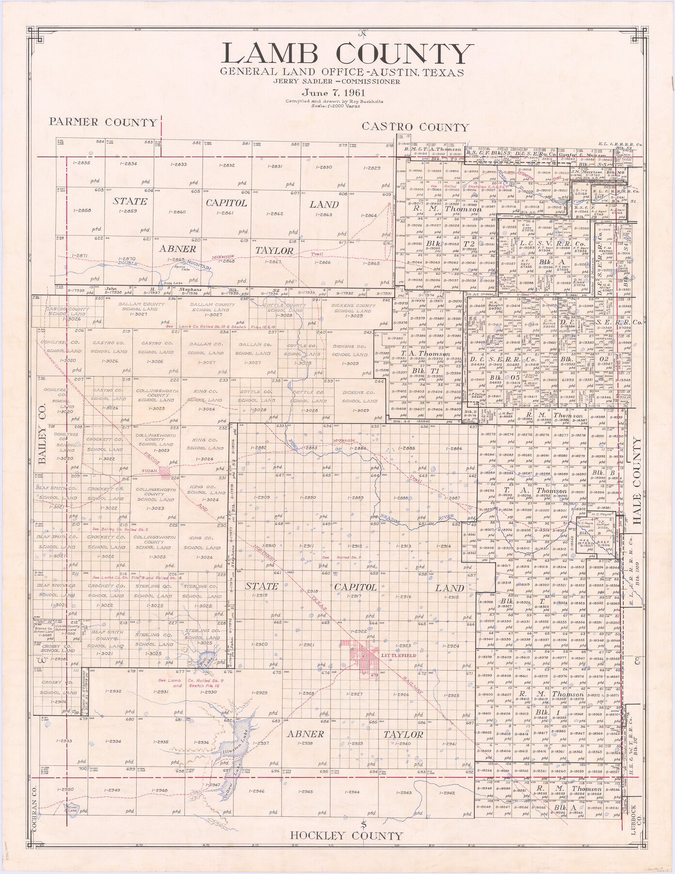
Lamb County
-
Map/Doc
73213
-
Collection
General Map Collection
-
Object Dates
1961/6/7 (Creation Date)
-
People and Organizations
Jerry Sadler (GLO Commissioner)
Roy Buckholts (Draftsman)
Roy Buckholts (Compiler)
-
Counties
Lamb
-
Subjects
County
-
Height x Width
45.2 x 35.4 inches
114.8 x 89.9 cm
-
Comments
Hand lettered.
-
Features
Running Water Creek
McKenzie Trail
Soda Lake
Spring Lake
Double Mountain Fork of Brazos River
P&NT
Sudan
Littlefield
Bull Lake
Illusion Lake
Yellow Lake
Silver Lake
Catfish Creek
Part of: General Map Collection

Gulf Intracoastal Waterway, Tex. - Aransas Bay to Corpus Christi Bay - Modified Route of Main Channel/Dredging

Print $20.00
- Digital $50.00
Gulf Intracoastal Waterway, Tex. - Aransas Bay to Corpus Christi Bay - Modified Route of Main Channel/Dredging
1958
Size 30.8 x 42.8 inches
Map/Doc 61896
Harris County Sketch File B

Print $4.00
- Digital $50.00
Harris County Sketch File B
1860
Size 8.0 x 5.5 inches
Map/Doc 25309
Reagan County Rolled Sketch 12

Print $20.00
- Digital $50.00
Reagan County Rolled Sketch 12
1940
Size 25.9 x 27.0 inches
Map/Doc 7440
San Jacinto County Working Sketch 30

Print $20.00
- Digital $50.00
San Jacinto County Working Sketch 30
Size 18.2 x 24.4 inches
Map/Doc 63743
Tyler County Rolled Sketch 4

Print $20.00
- Digital $50.00
Tyler County Rolled Sketch 4
1952
Size 38.9 x 44.0 inches
Map/Doc 10028
Tom Green County

Print $40.00
- Digital $50.00
Tom Green County
1942
Size 55.7 x 46.7 inches
Map/Doc 95655
Burnet County Sketch File 14

Print $4.00
- Digital $50.00
Burnet County Sketch File 14
Size 15.1 x 8.9 inches
Map/Doc 16698
Flight Mission No. BRE-1P, Frame 57, Nueces County

Print $20.00
- Digital $50.00
Flight Mission No. BRE-1P, Frame 57, Nueces County
1956
Size 18.5 x 22.2 inches
Map/Doc 86646
Flight Mission No. BRA-7M, Frame 130, Jefferson County

Print $20.00
- Digital $50.00
Flight Mission No. BRA-7M, Frame 130, Jefferson County
1953
Size 16.2 x 16.0 inches
Map/Doc 85524
Flight Mission No. BRA-9M, Frame 62, Jefferson County

Print $20.00
- Digital $50.00
Flight Mission No. BRA-9M, Frame 62, Jefferson County
1953
Size 18.7 x 22.3 inches
Map/Doc 85645
Map of Texas and part of New Mexico compiled in the Bureau of Topographl. Engrs. chiefly for military purposes

Print $20.00
- Digital $50.00
Map of Texas and part of New Mexico compiled in the Bureau of Topographl. Engrs. chiefly for military purposes
1857
Size 18.8 x 24.8 inches
Map/Doc 97116
You may also like
Map of Anderson County

Print $20.00
- Digital $50.00
Map of Anderson County
1879
Size 18.9 x 23.5 inches
Map/Doc 3229
Burnet County Working Sketch 5

Print $20.00
- Digital $50.00
Burnet County Working Sketch 5
1956
Size 30.0 x 19.3 inches
Map/Doc 67848
Flight Mission No. BRE-3P, Frame 35, Nueces County

Print $20.00
- Digital $50.00
Flight Mission No. BRE-3P, Frame 35, Nueces County
1956
Size 18.5 x 21.1 inches
Map/Doc 86813
Map of Texas and Pacific Ry. Company's Surveys in the 80 Mile Reserve

Print $40.00
- Digital $50.00
Map of Texas and Pacific Ry. Company's Surveys in the 80 Mile Reserve
1885
Size 41.5 x 91.8 inches
Map/Doc 60313
Throckmorton Co.

Print $20.00
- Digital $50.00
Throckmorton Co.
1898
Size 41.7 x 36.7 inches
Map/Doc 63064
Wilbarger County Working Sketch 10

Print $20.00
- Digital $50.00
Wilbarger County Working Sketch 10
1951
Size 23.5 x 32.3 inches
Map/Doc 72548
Calhoun County Rolled Sketch 29C

Print $20.00
- Digital $50.00
Calhoun County Rolled Sketch 29C
1977
Size 22.0 x 24.0 inches
Map/Doc 8559
Calhoun County Sketch File 8

Print $12.00
- Digital $50.00
Calhoun County Sketch File 8
1948
Size 14.2 x 9.0 inches
Map/Doc 35930
Webb County Sketch File D

Print $6.00
- Digital $50.00
Webb County Sketch File D
1876
Size 14.4 x 9.0 inches
Map/Doc 39678
Culberson County Sketch File 23

Print $10.00
- Digital $50.00
Culberson County Sketch File 23
1938
Size 14.2 x 8.6 inches
Map/Doc 20238
Motley County Sketch File 32 (S)

Print $4.00
- Digital $50.00
Motley County Sketch File 32 (S)
Size 11.3 x 8.7 inches
Map/Doc 32215
Aransas County Rolled Sketch 15A

Print $20.00
- Digital $50.00
Aransas County Rolled Sketch 15A
1969
Size 26.3 x 25.4 inches
Map/Doc 8411