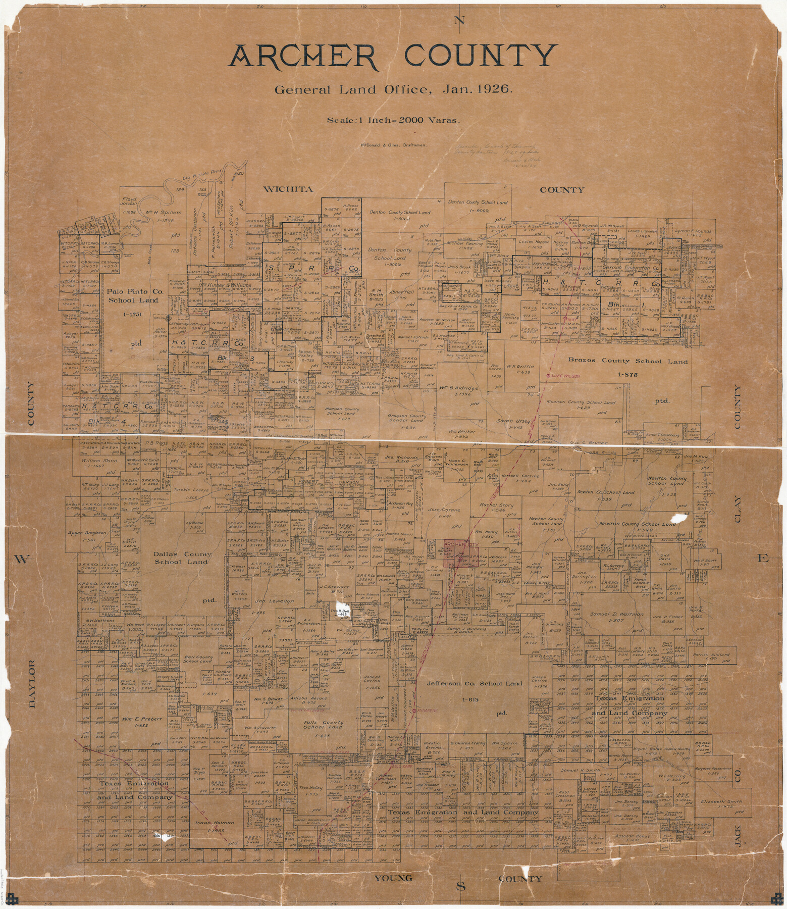
Archer County
-
Map/Doc
73070
-
Collection
General Map Collection
-
Object Dates
1/1926 (Creation Date)
-
People and Organizations
Texas General Land Office (Publisher)
McDonald and Giles (Draftsman)
-
Counties
Archer
-
Subjects
County
-
Height x Width
42.9 x 37.8 inches
109.0 x 96.0 cm
-
Features
Annarene [sic]
WVRR
Little Post Oak Creek
Dundee
Santa Anna's Creek
Mankins
Rush Creek
Willow Creek Lake
Preston Road
GT&W
Bell Camp
Belknap Road
West Fork of Trinity River
Big Wichita River
Archer City
Onion Creek
Post Oak Creek
Little Wichita River
Luke Wilson
Corn Hill
Huff
WF&S
Holliday [sic] Creek
Horse Shoe Lake
Bob's Creek
Valley Creek
Part of: General Map Collection
Coleman County Sketch File 30

Print $8.00
- Digital $50.00
Coleman County Sketch File 30
1875
Size 10.0 x 8.0 inches
Map/Doc 18720
La Salle County Working Sketch 2

Print $20.00
- Digital $50.00
La Salle County Working Sketch 2
1886
Size 17.6 x 16.0 inches
Map/Doc 70303
Hutchinson County Sketch File 36

Print $10.00
- Digital $50.00
Hutchinson County Sketch File 36
1941
Size 11.2 x 8.9 inches
Map/Doc 27270
Brazos Santiago, Texas

Print $20.00
- Digital $50.00
Brazos Santiago, Texas
1882
Size 9.0 x 16.9 inches
Map/Doc 97186
Crockett County Rolled Sketch 6

Print $40.00
- Digital $50.00
Crockett County Rolled Sketch 6
Size 54.7 x 24.3 inches
Map/Doc 8690
Gregg County Boundary File 2

Print $8.00
- Digital $50.00
Gregg County Boundary File 2
Size 8.8 x 3.7 inches
Map/Doc 53984
Estes Quadrangle

Print $20.00
- Digital $50.00
Estes Quadrangle
1971
Size 27.8 x 23.6 inches
Map/Doc 73442
Flight Mission No. DQN-6K, Frame 69, Calhoun County

Print $20.00
- Digital $50.00
Flight Mission No. DQN-6K, Frame 69, Calhoun County
1953
Size 18.6 x 22.1 inches
Map/Doc 84441
Austin including Bergstrom AFB, Hays, Mansfield Dam, McKinney Falls State Park, Oak Hill, Rollingwood, San Leanna, Sunset Valley and West Lake Hills - also portions of Pflugerville

Austin including Bergstrom AFB, Hays, Mansfield Dam, McKinney Falls State Park, Oak Hill, Rollingwood, San Leanna, Sunset Valley and West Lake Hills - also portions of Pflugerville
Size 38.5 x 25.6 inches
Map/Doc 94376
Lee County Sketch File 4a

Print $4.00
- Digital $50.00
Lee County Sketch File 4a
1860
Size 12.9 x 8.2 inches
Map/Doc 29684
Flight Mission No. DCL-7C, Frame 16, Kenedy County

Print $20.00
- Digital $50.00
Flight Mission No. DCL-7C, Frame 16, Kenedy County
1943
Size 15.2 x 15.4 inches
Map/Doc 86008
Houston County Sketch File 3

Print $6.00
- Digital $50.00
Houston County Sketch File 3
Size 13.1 x 8.2 inches
Map/Doc 26748
You may also like
Index for Texas Railroad ROW & track maps available on microfilm at THD & Archives and Records

Print $2.00
- Digital $50.00
Index for Texas Railroad ROW & track maps available on microfilm at THD & Archives and Records
1977
Size 11.1 x 8.6 inches
Map/Doc 60763
Intracoastal Waterway in Texas - Corpus Christi to Point Isabel including Arroyo Colorado to Mo. Pac. R.R. Bridge Near Harlingen

Print $20.00
- Digital $50.00
Intracoastal Waterway in Texas - Corpus Christi to Point Isabel including Arroyo Colorado to Mo. Pac. R.R. Bridge Near Harlingen
1933
Size 28.2 x 40.7 inches
Map/Doc 61856
Flight Mission No. CRC-3R, Frame 13, Chambers County

Print $20.00
- Digital $50.00
Flight Mission No. CRC-3R, Frame 13, Chambers County
1956
Size 18.5 x 22.3 inches
Map/Doc 84787
General Highway Map, Kendall County, Texas

Print $20.00
General Highway Map, Kendall County, Texas
1961
Size 18.3 x 24.6 inches
Map/Doc 79549
Central Europe designed to accompany Smith's Geography for Schools

Print $20.00
- Digital $50.00
Central Europe designed to accompany Smith's Geography for Schools
1850
Size 12.1 x 9.8 inches
Map/Doc 93895
Shelby County Working Sketch 35

Print $20.00
- Digital $50.00
Shelby County Working Sketch 35
2010
Size 27.4 x 28.3 inches
Map/Doc 89285
Karnes County Working Sketch 11

Print $40.00
- Digital $50.00
Karnes County Working Sketch 11
1975
Size 38.1 x 53.6 inches
Map/Doc 66659
Coleman County Sketch File 36

Print $20.00
- Digital $50.00
Coleman County Sketch File 36
1878
Size 24.5 x 30.8 inches
Map/Doc 11122
The United States and the Relative Position of the Oregon and Texas

Print $20.00
- Digital $50.00
The United States and the Relative Position of the Oregon and Texas
1850
Size 16.8 x 23.1 inches
Map/Doc 93666
Liberty County Sketch File 5b

Print $6.00
- Digital $50.00
Liberty County Sketch File 5b
1857
Size 8.0 x 3.5 inches
Map/Doc 29890
Travis County Working Sketch 64

Print $20.00
- Digital $50.00
Travis County Working Sketch 64
2000
Size 16.8 x 19.6 inches
Map/Doc 69448
Upton County Sketch File 27

Print $20.00
- Digital $50.00
Upton County Sketch File 27
1928
Size 42.9 x 22.6 inches
Map/Doc 10416