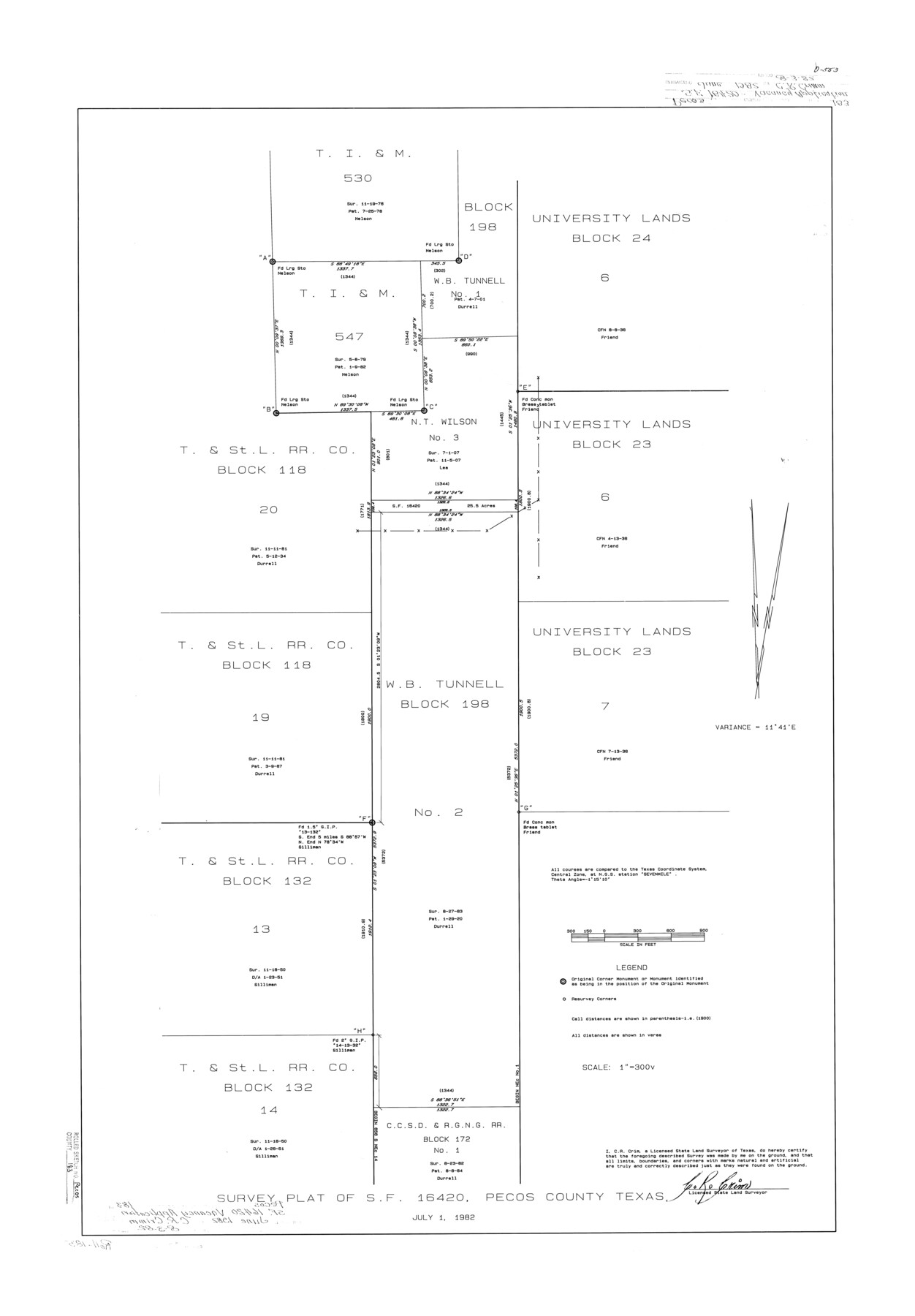
Pecos County Rolled Sketch 183
Survey plat of SF-16420, Pecos County, Texas
-
Map/Doc
7302
-
Collection
General Map Collection
-
Object Dates
1982/7/1 (Creation Date)
1982/8/3 (File Date)
-
People and Organizations
C.R. Crim (Surveyor/Engineer)
-
Counties
Pecos
-
Subjects
Surveying Rolled Sketch
-
Height x Width
39.6 x 27.5 inches
100.6 x 69.9 cm
-
Medium
mylar, print
-
Scale
1" = 300 varas
Part of: General Map Collection
Parker County Sketch File 4

Print $6.00
- Digital $50.00
Parker County Sketch File 4
1856
Size 6.2 x 5.8 inches
Map/Doc 33525
Flight Mission No. DAG-23K, Frame 163, Matagorda County

Print $20.00
- Digital $50.00
Flight Mission No. DAG-23K, Frame 163, Matagorda County
1953
Size 18.6 x 22.4 inches
Map/Doc 86501
Flight Mission No. DCL-6C, Frame 175, Kenedy County

Print $20.00
- Digital $50.00
Flight Mission No. DCL-6C, Frame 175, Kenedy County
1943
Size 18.6 x 22.3 inches
Map/Doc 85987
Flight Mission No. CLL-1N, Frame 13, Willacy County

Print $20.00
- Digital $50.00
Flight Mission No. CLL-1N, Frame 13, Willacy County
1954
Size 18.3 x 22.0 inches
Map/Doc 87000
Colorado County Working Sketch 21

Print $20.00
- Digital $50.00
Colorado County Working Sketch 21
1963
Size 32.1 x 30.5 inches
Map/Doc 68121
Webb County Working Sketch 75

Print $40.00
- Digital $50.00
Webb County Working Sketch 75
1975
Size 59.2 x 46.0 inches
Map/Doc 72442
Zavala County Rolled Sketch 25

Print $20.00
- Digital $50.00
Zavala County Rolled Sketch 25
1952
Size 38.4 x 43.4 inches
Map/Doc 10176
Flight Mission No. BRA-6M, Frame 145, Jefferson County

Print $20.00
- Digital $50.00
Flight Mission No. BRA-6M, Frame 145, Jefferson County
1953
Size 18.4 x 22.4 inches
Map/Doc 85446
Reagan County Working Sketch 30

Print $40.00
- Digital $50.00
Reagan County Working Sketch 30
1963
Size 31.9 x 57.3 inches
Map/Doc 71872
Hudspeth County Working Sketch 25

Print $20.00
- Digital $50.00
Hudspeth County Working Sketch 25
1971
Size 24.6 x 28.0 inches
Map/Doc 66307
Baylor County Sketch File A9

Print $8.00
- Digital $50.00
Baylor County Sketch File A9
1926
Size 11.4 x 8.9 inches
Map/Doc 14096
Terrell County Working Sketch 73

Print $20.00
- Digital $50.00
Terrell County Working Sketch 73
1980
Size 29.0 x 47.5 inches
Map/Doc 69594
You may also like
Sketch of Surveys on Peach Point, J. Perry's Property

Print $20.00
- Digital $50.00
Sketch of Surveys on Peach Point, J. Perry's Property
1832
Size 14.0 x 20.6 inches
Map/Doc 219
Carte de la Louisiane et Pays Voisins Pour servir a l'Histoire Generale des Voyages

Print $20.00
Carte de la Louisiane et Pays Voisins Pour servir a l'Histoire Generale des Voyages
1757
Size 9.6 x 14.9 inches
Map/Doc 94572
El Paso County Sketch File 18

Print $20.00
- Digital $50.00
El Paso County Sketch File 18
Size 19.0 x 23.8 inches
Map/Doc 11454
Parker County Sketch File 27

Print $20.00
- Digital $50.00
Parker County Sketch File 27
1876
Size 23.7 x 23.8 inches
Map/Doc 12146
[Sketch showing H. and T. C. Blocks 46 and 47]
![91735, [Sketch showing H. and T. C. Blocks 46 and 47], Twichell Survey Records](https://historictexasmaps.com/wmedia_w700/maps/91735-1.tif.jpg)
Print $20.00
- Digital $50.00
[Sketch showing H. and T. C. Blocks 46 and 47]
1884
Size 38.5 x 24.7 inches
Map/Doc 91735
The City of Austin and Suburbs

Print $40.00
- Digital $50.00
The City of Austin and Suburbs
1919
Size 120.7 x 41.2 inches
Map/Doc 88863
Foard County Rolled Sketch 11

Print $20.00
- Digital $50.00
Foard County Rolled Sketch 11
Size 29.2 x 35.6 inches
Map/Doc 5885
Hudspeth County Sketch File 20

Print $40.00
- Digital $50.00
Hudspeth County Sketch File 20
Size 37.1 x 57.3 inches
Map/Doc 10494
Current Miscellaneous File 111

Print $8.00
- Digital $50.00
Current Miscellaneous File 111
1996
Size 11.3 x 8.7 inches
Map/Doc 74714
General Highway Map, Stonewall County, Texas

Print $20.00
General Highway Map, Stonewall County, Texas
1940
Size 18.3 x 24.8 inches
Map/Doc 79249
Crane County Map of Unsurveyed School Lands for Bob Reid's Application to Lease

Print $40.00
- Digital $50.00
Crane County Map of Unsurveyed School Lands for Bob Reid's Application to Lease
1946
Size 49.0 x 51.3 inches
Map/Doc 90466
