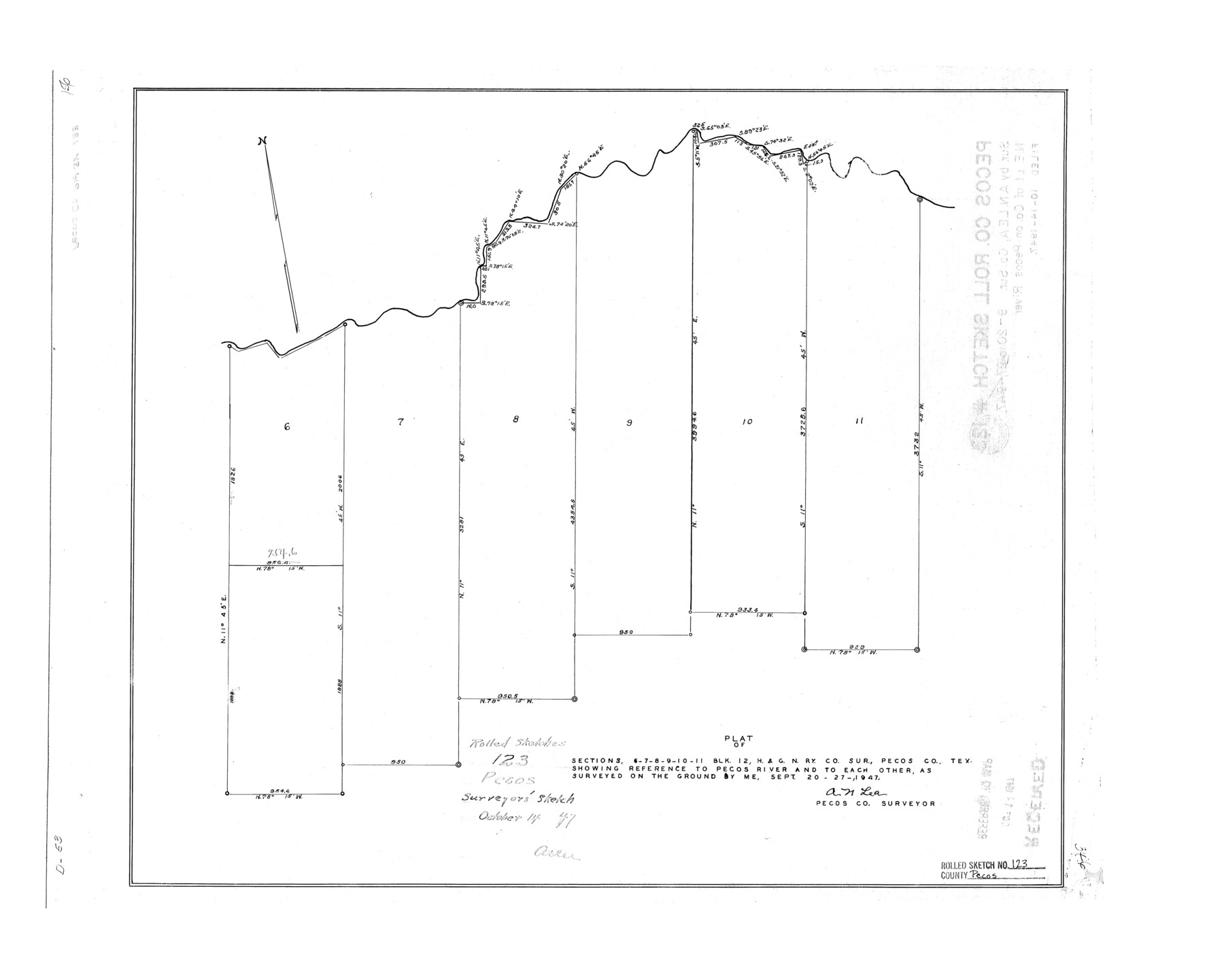
Pecos County Rolled Sketch 123
Plat of sections 6, 7, 8, 9, 10, 11, Blk. 12, H. & G. N. Ry. Co. sur., Pecos Co., Tex. showing reference to Pecos River and to each other
-
Map/Doc
7264
-
Collection
General Map Collection
-
Object Dates
1947/9/27 (Survey Date)
1947/10/14 (File Date)
-
People and Organizations
A.N. Lea (Surveyor/Engineer)
-
Counties
Pecos
-
Subjects
Surveying Rolled Sketch
-
Height x Width
20.3 x 25.4 inches
51.6 x 64.5 cm
Part of: General Map Collection
Kimble County Working Sketch 58

Print $20.00
- Digital $50.00
Kimble County Working Sketch 58
1959
Size 12.8 x 26.4 inches
Map/Doc 70126
Trinity River, Cooks Ferry Sheet

Print $40.00
- Digital $50.00
Trinity River, Cooks Ferry Sheet
1926
Size 36.5 x 56.2 inches
Map/Doc 65215
Flight Mission No. CGI-3N, Frame 178, Cameron County

Print $20.00
- Digital $50.00
Flight Mission No. CGI-3N, Frame 178, Cameron County
1954
Size 18.5 x 22.2 inches
Map/Doc 84642
Harris County Sketch File 62

Print $14.00
- Digital $50.00
Harris County Sketch File 62
1930
Size 11.4 x 8.7 inches
Map/Doc 25486
Schleicher County Sketch File 22

Print $9.00
- Digital $50.00
Schleicher County Sketch File 22
1927
Size 12.8 x 11.7 inches
Map/Doc 36512
Winkler County Working Sketch 19

Print $20.00
- Digital $50.00
Winkler County Working Sketch 19
1990
Size 29.4 x 25.7 inches
Map/Doc 72613
Flight Mission No. DIX-5P, Frame 140, Aransas County

Print $20.00
- Digital $50.00
Flight Mission No. DIX-5P, Frame 140, Aransas County
1956
Size 17.8 x 18.5 inches
Map/Doc 83801
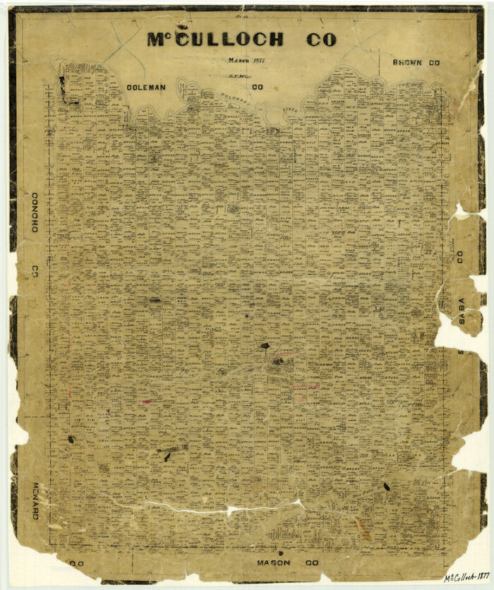
McCulloch County
Print $20.00
- Digital $50.00
McCulloch County
1877
Size 21.3 x 17.9 inches
Map/Doc 3858
Map showing survey for proposed ship channel from Brownsville to Brazos Santiago Pass

Print $20.00
- Digital $50.00
Map showing survey for proposed ship channel from Brownsville to Brazos Santiago Pass
1912
Size 18.1 x 28.0 inches
Map/Doc 72899
Packery Channel

Print $3.00
- Digital $50.00
Packery Channel
1962
Size 10.6 x 12.8 inches
Map/Doc 3006
Foard County Sketch File XX

Print $40.00
- Digital $50.00
Foard County Sketch File XX
1884
Size 14.0 x 16.4 inches
Map/Doc 22802
Hays County Working Sketch Graphic Index

Print $20.00
- Digital $50.00
Hays County Working Sketch Graphic Index
1946
Size 43.7 x 40.9 inches
Map/Doc 76573
You may also like
Flight Mission No. CLL-1N, Frame 106, Willacy County

Print $20.00
- Digital $50.00
Flight Mission No. CLL-1N, Frame 106, Willacy County
1954
Size 18.4 x 22.0 inches
Map/Doc 87040
Brewster County Sketch File N-13

Print $8.00
- Digital $50.00
Brewster County Sketch File N-13
1935
Size 14.3 x 8.7 inches
Map/Doc 15625

Harris County Sketch File 58

Print $20.00
- Digital $50.00
Harris County Sketch File 58
1920
Size 27.6 x 21.4 inches
Map/Doc 11657
Gaines County Rolled Sketch 15A

Print $40.00
- Digital $50.00
Gaines County Rolled Sketch 15A
Size 90.5 x 23.8 inches
Map/Doc 9036

Montgomery County Working Sketch 52

Print $20.00
- Digital $50.00
Montgomery County Working Sketch 52
1960
Size 37.8 x 43.3 inches
Map/Doc 71159
Flight Mission No. DQN-1K, Frame 107, Calhoun County

Print $20.00
- Digital $50.00
Flight Mission No. DQN-1K, Frame 107, Calhoun County
1953
Size 18.4 x 22.3 inches
Map/Doc 84174
Flight Mission No. DQN-1K, Frame 123, Calhoun County

Print $20.00
- Digital $50.00
Flight Mission No. DQN-1K, Frame 123, Calhoun County
1953
Size 18.4 x 22.2 inches
Map/Doc 84189
Aransas County Sketch File 30

Print $74.00
- Digital $50.00
Aransas County Sketch File 30
Size 14.2 x 8.7 inches
Map/Doc 13237
Map of Sabine County

Print $20.00
- Digital $50.00
Map of Sabine County
1896
Size 26.6 x 19.3 inches
Map/Doc 4010
[I. & G. N. Block 1]
![91592, [I. & G. N. Block 1], Twichell Survey Records](https://historictexasmaps.com/wmedia_w700/maps/91592-1.tif.jpg)
Print $20.00
- Digital $50.00
[I. & G. N. Block 1]
Size 17.2 x 18.1 inches
Map/Doc 91592