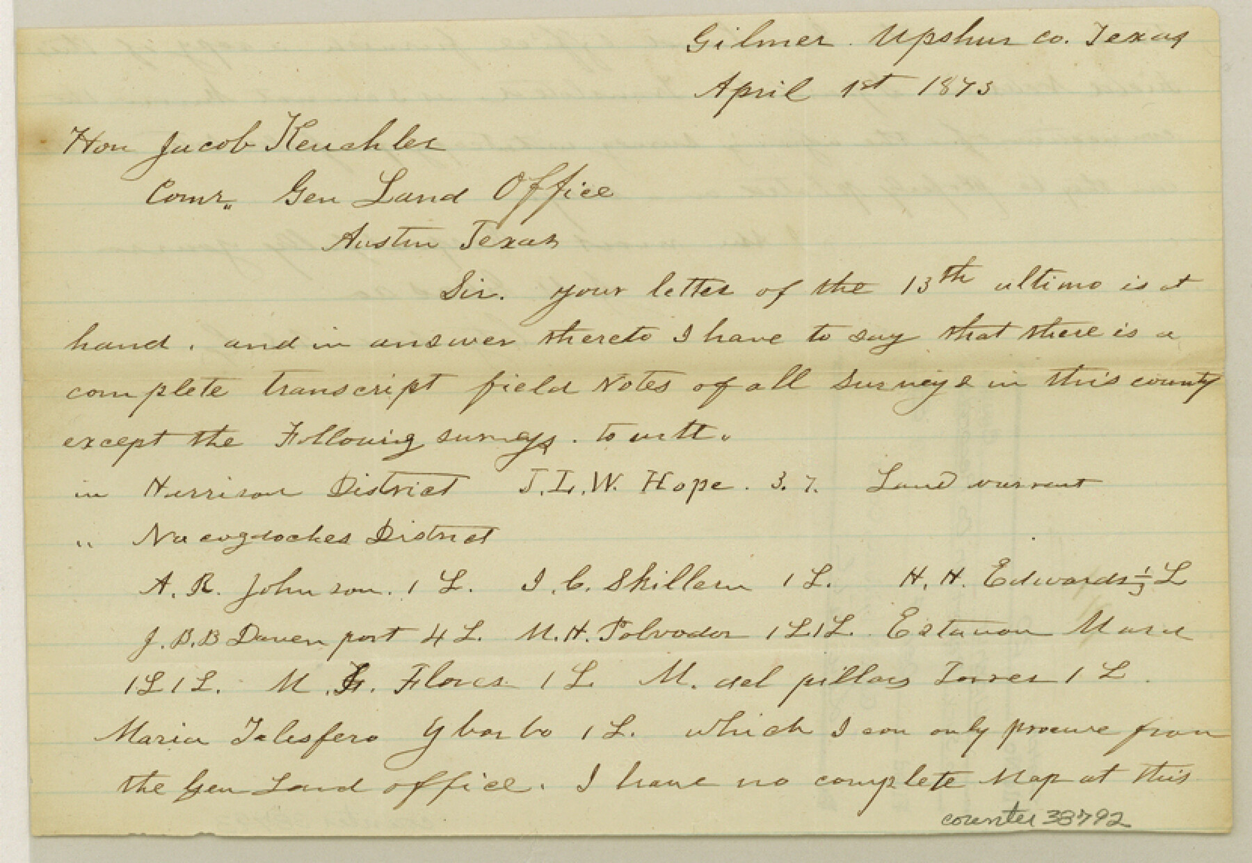
Upshur County Sketch File 20
[County Surveyor report on county records]
-
Map/Doc
38792
-
Collection
General Map Collection
-
Object Dates
4/1/1873 (Creation Date)
12/4/1984 (File Date)
-
People and Organizations
J.M. Glasco (Surveyor/Engineer)
-
Counties
Upshur
-
Subjects
Surveying Sketch File
-
Height x Width
5.7 x 8.3 inches
14.5 x 21.1 cm
-
Medium
paper, manuscript
Part of: General Map Collection
Haskell County Sketch File 11

Print $6.00
- Digital $50.00
Haskell County Sketch File 11
1886
Size 16.0 x 10.7 inches
Map/Doc 26140
Grayson County Boundary File 2a

Print $60.00
- Digital $50.00
Grayson County Boundary File 2a
Size 43.7 x 9.8 inches
Map/Doc 53938
Reagan County Rolled Sketch 27A

Print $40.00
- Digital $50.00
Reagan County Rolled Sketch 27A
1952
Size 63.7 x 47.2 inches
Map/Doc 9822
Uvalde County Working Sketch 22

Print $20.00
- Digital $50.00
Uvalde County Working Sketch 22
1950
Size 26.1 x 18.5 inches
Map/Doc 72092
[Texas & Pacific Railway through Callahan County]
![64234, [Texas & Pacific Railway through Callahan County], General Map Collection](https://historictexasmaps.com/wmedia_w700/maps/64234.tif.jpg)
Print $20.00
- Digital $50.00
[Texas & Pacific Railway through Callahan County]
1918
Size 21.3 x 8.8 inches
Map/Doc 64234
El Paso County Working Sketch 58

Print $20.00
- Digital $50.00
El Paso County Working Sketch 58
Size 25.8 x 30.6 inches
Map/Doc 69080
Stonewall County Rolled Sketch 7
Print $20.00
- Digital $50.00
Stonewall County Rolled Sketch 7
1890
Size 16.6 x 37.9 inches
Map/Doc 7864
Rusk County Sketch File 20

Print $4.00
Rusk County Sketch File 20
1859
Size 10.2 x 8.1 inches
Map/Doc 35530
Map of Eastland Co.

Print $20.00
- Digital $50.00
Map of Eastland Co.
1896
Size 40.8 x 43.8 inches
Map/Doc 66809
Dallam County Working Sketch 1

Print $20.00
- Digital $50.00
Dallam County Working Sketch 1
1905
Size 15.9 x 13.6 inches
Map/Doc 68586
Liberty County Rolled Sketch 13

Print $20.00
- Digital $50.00
Liberty County Rolled Sketch 13
1983
Size 27.0 x 37.8 inches
Map/Doc 6619
Hudspeth County Rolled Sketch 46

Print $40.00
- Digital $50.00
Hudspeth County Rolled Sketch 46
Size 10.2 x 128.3 inches
Map/Doc 76039
You may also like
Sketch of a reconnaissance of Aransas and Corpus Christi Bays

Print $20.00
- Digital $50.00
Sketch of a reconnaissance of Aransas and Corpus Christi Bays
1855
Size 25.7 x 18.3 inches
Map/Doc 72969
Tyler County Working Sketch 4

Print $20.00
- Digital $50.00
Tyler County Working Sketch 4
1926
Size 19.4 x 35.8 inches
Map/Doc 69474
Denton County Sketch File 25

Print $4.00
- Digital $50.00
Denton County Sketch File 25
1863
Size 8.0 x 7.4 inches
Map/Doc 20752
Robertson County Rolled Sketch 5

Print $20.00
- Digital $50.00
Robertson County Rolled Sketch 5
1976
Size 34.1 x 36.4 inches
Map/Doc 9864
Gregg County Rolled Sketch 20

Print $20.00
- Digital $50.00
Gregg County Rolled Sketch 20
1957
Size 34.0 x 44.4 inches
Map/Doc 9070
McCulloch County Sketch File 1

Print $4.00
- Digital $50.00
McCulloch County Sketch File 1
1854
Size 8.7 x 6.8 inches
Map/Doc 31165
Jefferson County Sketch File 26a

Print $20.00
- Digital $50.00
Jefferson County Sketch File 26a
Size 19.5 x 11.6 inches
Map/Doc 11872
Pecos County Working Sketch 140

Print $20.00
- Digital $50.00
Pecos County Working Sketch 140
1983
Size 43.1 x 42.9 inches
Map/Doc 71614

[Cherokee Reserve, West Boundary Line, plat and field notes]
![2000, [Cherokee Reserve, West Boundary Line, plat and field notes], General Map Collection](https://historictexasmaps.com/wmedia_w700/pdf_converted_jpg/qi_pdf_thumbnail_931.jpg)
Print $54.00
[Cherokee Reserve, West Boundary Line, plat and field notes]
1841
Size 9.4 x 14.7 inches
Map/Doc 2000
North Part Brewster Co.

Print $40.00
- Digital $50.00
North Part Brewster Co.
1914
Size 48.4 x 37.8 inches
Map/Doc 89864
Harris County Sketch File 71

Print $5.00
- Digital $50.00
Harris County Sketch File 71
1941
Size 14.4 x 9.0 inches
Map/Doc 25523