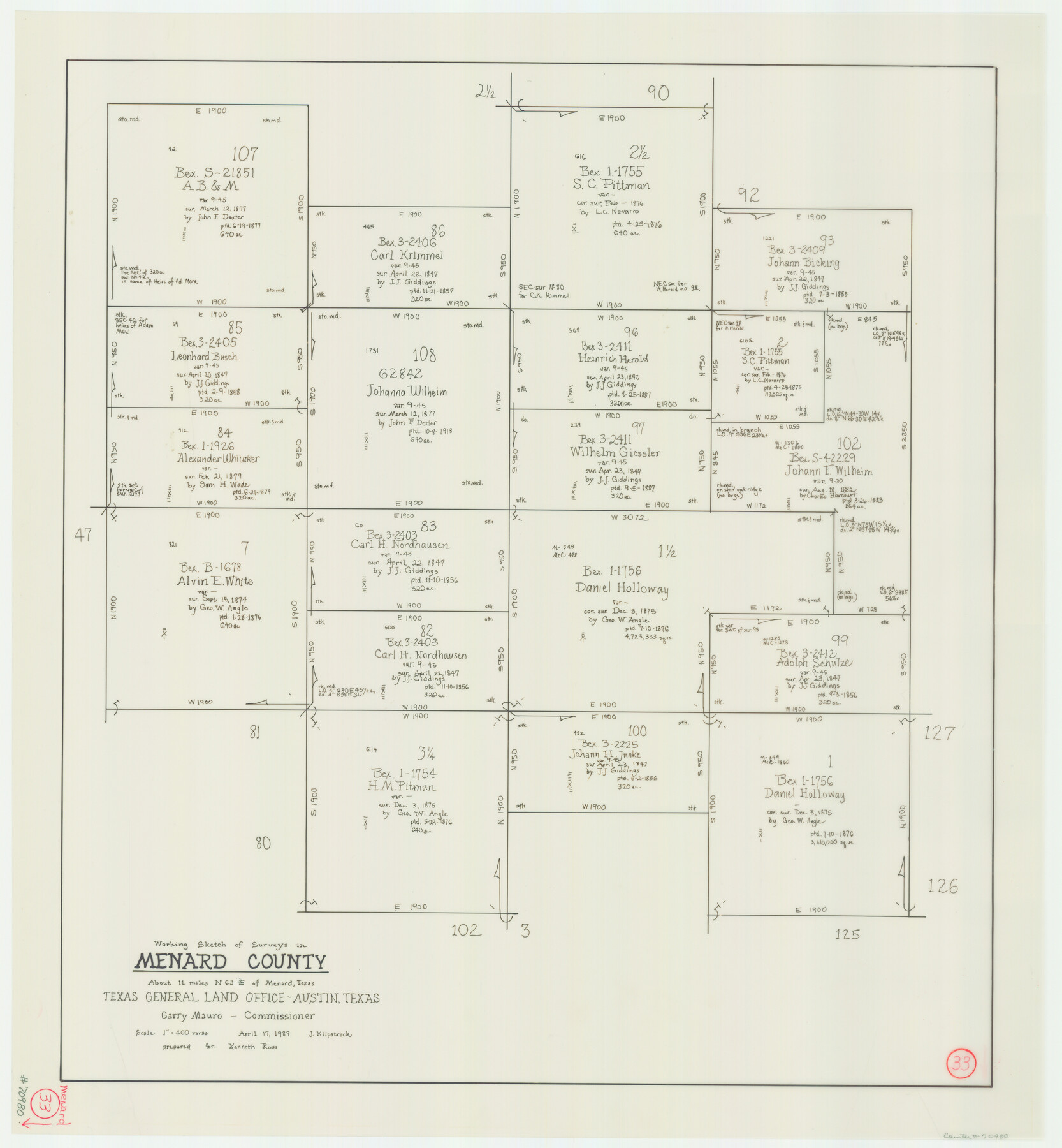
Menard County Working Sketch 33
-
Map/Doc
70980
-
Collection
General Map Collection
-
Object Dates
4/17/1989 (Creation Date)
-
People and Organizations
Joan Kilpatrick (Draftsman)
-
Counties
Menard
-
Subjects
Surveying Working Sketch
-
Height x Width
27.2 x 25.2 inches
69.1 x 64.0 cm
-
Scale
1" = 400 varas
Part of: General Map Collection
Karte von Texas entworfen nach den Vermessungen welche in den Acten der General Land Office der Republic liegen bis zum Jahr 1839

Print $20.00
- Digital $50.00
Karte von Texas entworfen nach den Vermessungen welche in den Acten der General Land Office der Republic liegen bis zum Jahr 1839
1845
Size 18.6 x 14.1 inches
Map/Doc 96629
Fractional Township No. 11 South Range No. 27 East of the Indian Meridian, Indian Territory

Print $20.00
- Digital $50.00
Fractional Township No. 11 South Range No. 27 East of the Indian Meridian, Indian Territory
1897
Size 19.2 x 24.3 inches
Map/Doc 75247
Denton County

Print $20.00
- Digital $50.00
Denton County
1947
Size 42.5 x 39.7 inches
Map/Doc 73130
Crosby County Sketch File 19

Print $6.00
- Digital $50.00
Crosby County Sketch File 19
1910
Size 8.2 x 8.1 inches
Map/Doc 20084
Hutchinson County Rolled Sketch 40

Print $20.00
- Digital $50.00
Hutchinson County Rolled Sketch 40
1981
Size 26.8 x 37.4 inches
Map/Doc 6303
Presidio County Rolled Sketch 28

Print $40.00
- Digital $50.00
Presidio County Rolled Sketch 28
1886
Size 25.7 x 120.0 inches
Map/Doc 76139
Archer County Sketch File 18

Print $40.00
- Digital $50.00
Archer County Sketch File 18
Size 23.9 x 13.0 inches
Map/Doc 10828
Nolan County Working Sketch 1

Print $20.00
- Digital $50.00
Nolan County Working Sketch 1
1928
Size 17.9 x 17.5 inches
Map/Doc 71292
Hill County Sketch File 24a

Print $40.00
- Digital $50.00
Hill County Sketch File 24a
Size 13.2 x 14.3 inches
Map/Doc 26518
Flight Mission No. DCL-4C, Frame 7, Kenedy County

Print $20.00
- Digital $50.00
Flight Mission No. DCL-4C, Frame 7, Kenedy County
1943
Size 18.6 x 22.3 inches
Map/Doc 85808
Edwards County Working Sketch 82

Print $20.00
- Digital $50.00
Edwards County Working Sketch 82
1964
Size 31.0 x 35.1 inches
Map/Doc 68958
Hudspeth County Working Sketch 47

Print $20.00
- Digital $50.00
Hudspeth County Working Sketch 47
1984
Size 28.4 x 41.1 inches
Map/Doc 66332
You may also like
Olton, Texas Voted County Seat of Lamb County

Print $20.00
- Digital $50.00
Olton, Texas Voted County Seat of Lamb County
Size 23.2 x 24.1 inches
Map/Doc 92151
Hockley County Sketch File 13

Print $4.00
- Digital $50.00
Hockley County Sketch File 13
1914
Size 8.9 x 10.9 inches
Map/Doc 26548
No. 1. Outline Map of the Rio Grande from its mouth up to Ringold Barracks

Print $20.00
- Digital $50.00
No. 1. Outline Map of the Rio Grande from its mouth up to Ringold Barracks
Size 24.8 x 18.3 inches
Map/Doc 72857
Taylor County Sketch File 2

Print $20.00
- Digital $50.00
Taylor County Sketch File 2
Size 13.8 x 18.4 inches
Map/Doc 12408
[Index map of T. & P. Ry. Company’s 80-mile Trans-Pecos Reserve’s perpetuated corners - North Part]
![89622, [Index map of T. & P. Ry. Company’s 80-mile Trans-Pecos Reserve’s perpetuated corners - North Part], General Map Collection](https://historictexasmaps.com/wmedia_w700/maps/89622-1.tif.jpg)
Print $40.00
- Digital $50.00
[Index map of T. & P. Ry. Company’s 80-mile Trans-Pecos Reserve’s perpetuated corners - North Part]
Size 25.4 x 92.1 inches
Map/Doc 89622
Dimmit County Working Sketch 48

Print $40.00
- Digital $50.00
Dimmit County Working Sketch 48
1980
Size 78.7 x 43.7 inches
Map/Doc 68709
[H. E. & W. T. Block 9, L. S. & V. Block 1, Public School Land Block C-40, Portion of Block H]
![91354, [H. E. & W. T. Block 9, L. S. & V. Block 1, Public School Land Block C-40, Portion of Block H], Twichell Survey Records](https://historictexasmaps.com/wmedia_w700/maps/91354-1.tif.jpg)
Print $20.00
- Digital $50.00
[H. E. & W. T. Block 9, L. S. & V. Block 1, Public School Land Block C-40, Portion of Block H]
Size 27.0 x 33.3 inches
Map/Doc 91354
Andrews County Rolled Sketch 43

Print $20.00
- Digital $50.00
Andrews County Rolled Sketch 43
Size 26.1 x 41.0 inches
Map/Doc 77183
Duval County Sketch File 81

Print $18.00
- Digital $50.00
Duval County Sketch File 81
Size 11.2 x 8.8 inches
Map/Doc 21507
Gillespie County Sketch File 3a

Print $4.00
- Digital $50.00
Gillespie County Sketch File 3a
1860
Size 7.6 x 8.3 inches
Map/Doc 24131
Map of Independence Area, Washington County, Texas

Print $20.00
- Digital $50.00
Map of Independence Area, Washington County, Texas
1935
Size 28.9 x 26.0 inches
Map/Doc 91990
Cass County Working Sketch 46

Print $20.00
- Digital $50.00
Cass County Working Sketch 46
1989
Size 26.8 x 30.6 inches
Map/Doc 67949