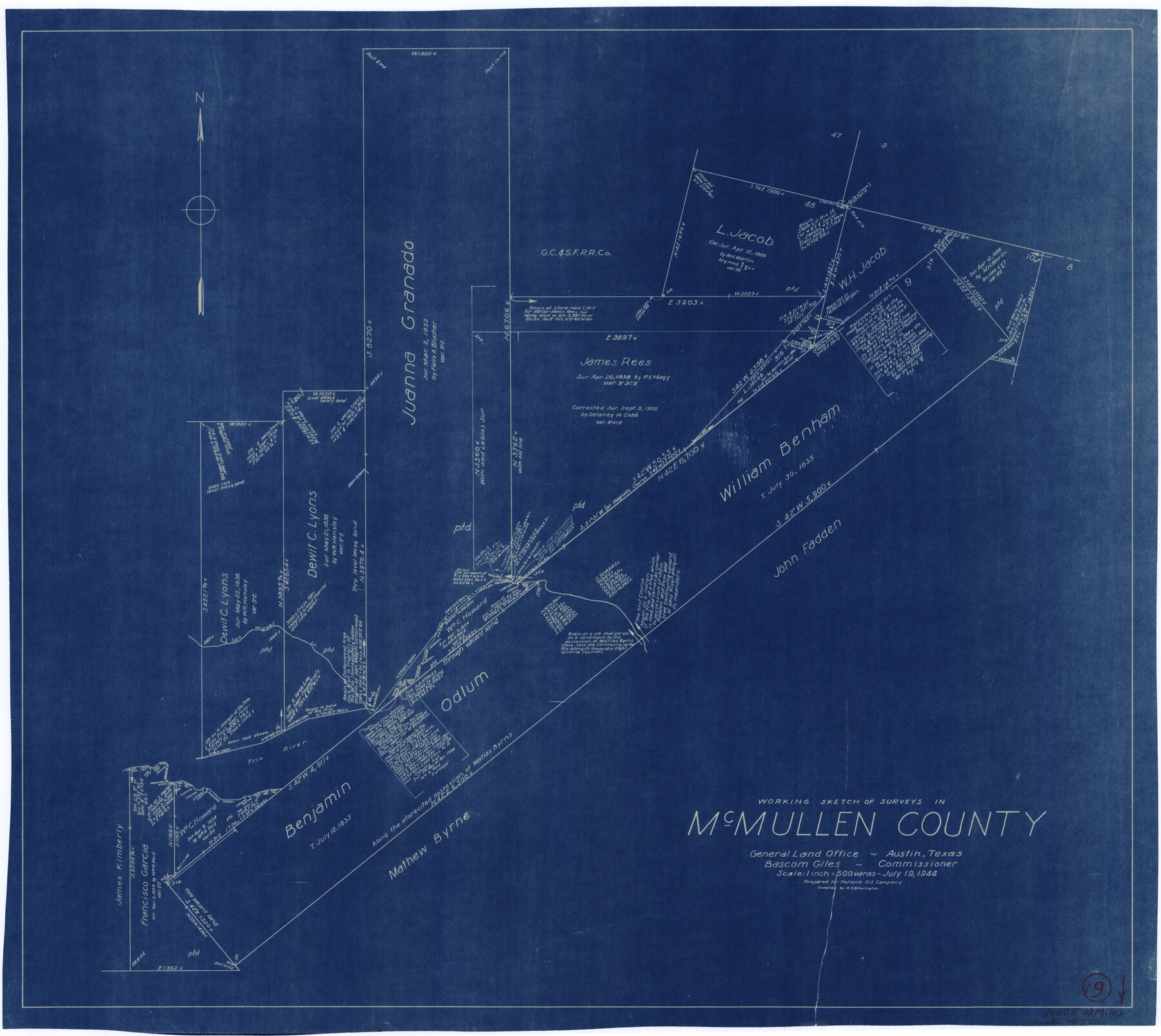
McMullen County Working Sketch 19
-
Map/Doc
70720
-
Collection
General Map Collection
-
Object Dates
7/19/1944 (Creation Date)
-
People and Organizations
W. S. Brewington (Draftsman)
-
Counties
McMullen
-
Subjects
Surveying Working Sketch
-
Height x Width
26.1 x 29.2 inches
66.3 x 74.2 cm
-
Scale
1" = 500 varas
Part of: General Map Collection
San Jacinto County Boundary File 1a

Print $58.00
- Digital $50.00
San Jacinto County Boundary File 1a
Size 14.5 x 8.9 inches
Map/Doc 58551
Carte Geo-Hydrographique du Golfe du Mexique et de ses Isles construite d'après les mémoires les plus recens, et assujeties, pour l'emplacement de ces principales positions aux latitudes et longitudes

Print $20.00
- Digital $50.00
Carte Geo-Hydrographique du Golfe du Mexique et de ses Isles construite d'après les mémoires les plus recens, et assujeties, pour l'emplacement de ces principales positions aux latitudes et longitudes
1771
Size 15.0 x 20.5 inches
Map/Doc 94108
Erath County Rolled Sketch 1

Print $40.00
- Digital $50.00
Erath County Rolled Sketch 1
1962
Size 37.6 x 69.0 inches
Map/Doc 8882
Llano County Sketch File 16

Print $12.00
- Digital $50.00
Llano County Sketch File 16
1905
Size 12.3 x 11.3 inches
Map/Doc 30392
Dallam County Boundary File 4

Print $80.00
- Digital $50.00
Dallam County Boundary File 4
Size 9.4 x 49.8 inches
Map/Doc 52082
Hood County Working Sketch 6

Print $40.00
- Digital $50.00
Hood County Working Sketch 6
1969
Size 39.4 x 48.0 inches
Map/Doc 66200
Flight Mission No. CGI-1N, Frame 166, Cameron County

Print $20.00
- Digital $50.00
Flight Mission No. CGI-1N, Frame 166, Cameron County
1955
Size 18.5 x 22.2 inches
Map/Doc 84501
Flight Mission No. CLL-1N, Frame 10, Willacy County

Print $20.00
- Digital $50.00
Flight Mission No. CLL-1N, Frame 10, Willacy County
1954
Size 18.5 x 22.1 inches
Map/Doc 86997
Hartley County Boundary File 3

Print $15.00
- Digital $50.00
Hartley County Boundary File 3
Size 6.7 x 16.5 inches
Map/Doc 54476
No. 1 - Survey for a road from the Brazo Santiago to the Rio Grande

Print $20.00
- Digital $50.00
No. 1 - Survey for a road from the Brazo Santiago to the Rio Grande
1847
Size 18.4 x 27.3 inches
Map/Doc 72875
Brazoria County NRC Article 33.136 Sketch 11

Print $24.00
- Digital $50.00
Brazoria County NRC Article 33.136 Sketch 11
2012
Size 24.0 x 18.0 inches
Map/Doc 94777
Brooks County Sketch File 7

Print $10.00
- Digital $50.00
Brooks County Sketch File 7
1946
Size 11.3 x 8.6 inches
Map/Doc 16566
You may also like
[Township 5-S, Blocks 36, 37 & 38]
![92292, [Township 5-S, Blocks 36, 37 & 38], Twichell Survey Records](https://historictexasmaps.com/wmedia_w700/maps/92292-1.tif.jpg)
Print $20.00
- Digital $50.00
[Township 5-S, Blocks 36, 37 & 38]
1952
Size 27.7 x 26.6 inches
Map/Doc 92292
Chambers County Boundary File 1

Print $28.00
- Digital $50.00
Chambers County Boundary File 1
Size 8.9 x 6.7 inches
Map/Doc 51226
Limestone County Sketch File 18

Print $6.00
- Digital $50.00
Limestone County Sketch File 18
Size 16.0 x 10.7 inches
Map/Doc 30191
Maps of Gulf Intracoastal Waterway, Texas - Sabine River to the Rio Grande and connecting waterways including ship channels

Print $20.00
- Digital $50.00
Maps of Gulf Intracoastal Waterway, Texas - Sabine River to the Rio Grande and connecting waterways including ship channels
1966
Size 14.5 x 22.3 inches
Map/Doc 61933
Montgomery County Working Sketch 60

Print $20.00
- Digital $50.00
Montgomery County Working Sketch 60
1963
Size 24.3 x 42.7 inches
Map/Doc 71167
[Unidentified Railroad through Denton and Dallas County]
![64775, [Unidentified Railroad through Denton and Dallas County], General Map Collection](https://historictexasmaps.com/wmedia_w700/maps/64775.tif.jpg)
Print $40.00
- Digital $50.00
[Unidentified Railroad through Denton and Dallas County]
Size 6.8 x 73.3 inches
Map/Doc 64775
[South Half - Brown County, Texas]
![97383, [South Half - Brown County, Texas], General Map Collection](https://historictexasmaps.com/wmedia_w700/maps/97383.tif.jpg)
Print $40.00
- Digital $50.00
[South Half - Brown County, Texas]
1919
Size 41.7 x 68.4 inches
Map/Doc 97383
Hudspeth County Sketch File 12

Print $10.00
- Digital $50.00
Hudspeth County Sketch File 12
1901
Size 14.2 x 8.7 inches
Map/Doc 26924
Gaines County Rolled Sketch 13

Print $40.00
- Digital $50.00
Gaines County Rolled Sketch 13
Size 70.1 x 23.1 inches
Map/Doc 9029
Castro County Sketch File 6

Print $20.00
- Digital $50.00
Castro County Sketch File 6
Size 20.8 x 15.6 inches
Map/Doc 11059
Dickens County Sketch File H1

Print $20.00
- Digital $50.00
Dickens County Sketch File H1
1902
Size 16.7 x 15.1 inches
Map/Doc 11336
