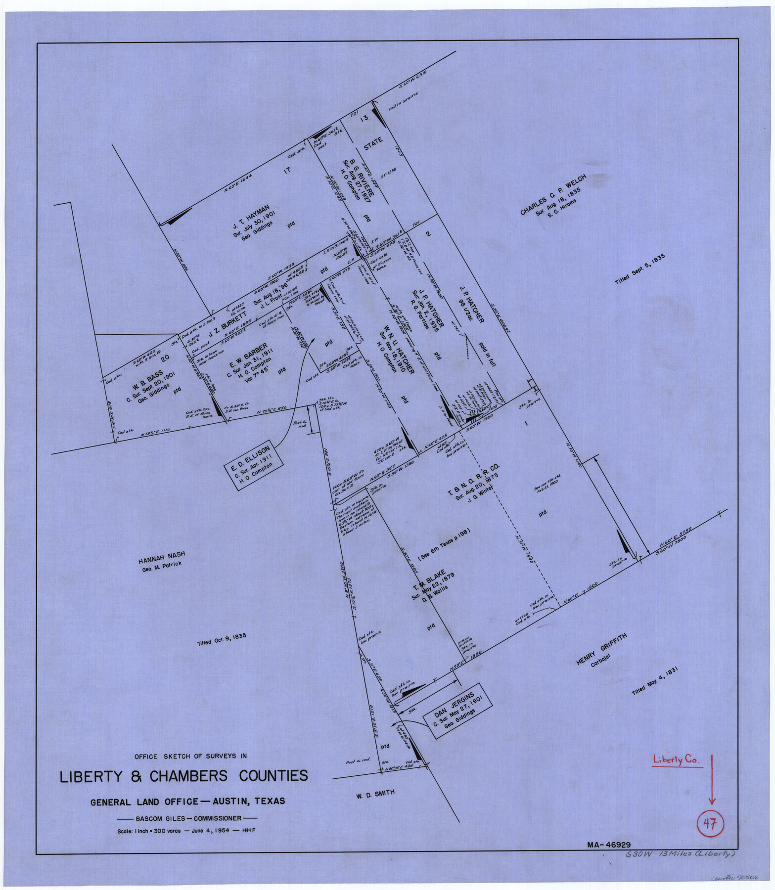
Liberty County Working Sketch 47
-
Map/Doc
70506
-
Collection
General Map Collection
-
Object Dates
6/4/1954 (Creation Date)
-
People and Organizations
Herman H. Forbes (Draftsman)
-
Counties
Liberty Chambers
-
Subjects
Surveying Working Sketch
-
Height x Width
28.3 x 24.6 inches
71.9 x 62.5 cm
-
Scale
1" = 300 varas
Part of: General Map Collection
Presidio County Working Sketch 24

Print $20.00
- Digital $50.00
Presidio County Working Sketch 24
1945
Size 18.0 x 11.9 inches
Map/Doc 71700
Orange County Sketch File 4

Print $34.00
- Digital $50.00
Orange County Sketch File 4
1852
Size 8.2 x 7.7 inches
Map/Doc 33301
Red River County Working Sketch 63

Print $20.00
- Digital $50.00
Red River County Working Sketch 63
1973
Size 43.6 x 37.0 inches
Map/Doc 72046
Cottle County

Print $20.00
- Digital $50.00
Cottle County
1908
Size 43.9 x 39.0 inches
Map/Doc 66788
Flight Mission No. BRA-6M, Frame 145, Jefferson County

Print $20.00
- Digital $50.00
Flight Mission No. BRA-6M, Frame 145, Jefferson County
1953
Size 18.4 x 22.4 inches
Map/Doc 85446
Crockett County Working Sketch 50

Print $20.00
- Digital $50.00
Crockett County Working Sketch 50
1940
Size 30.3 x 24.9 inches
Map/Doc 68383
Map of Baylor County Young Land District, formely Fannin District

Print $20.00
- Digital $50.00
Map of Baylor County Young Land District, formely Fannin District
1859
Size 25.8 x 20.0 inches
Map/Doc 3281
Outer Continental Shelf Leasing Maps (Louisiana Offshore Operations)

Print $20.00
- Digital $50.00
Outer Continental Shelf Leasing Maps (Louisiana Offshore Operations)
1955
Size 23.3 x 15.5 inches
Map/Doc 76094
Stonewall County Working Sketch 19

Print $20.00
- Digital $50.00
Stonewall County Working Sketch 19
1957
Size 35.3 x 35.1 inches
Map/Doc 62326
Wichita County Sketch File 19

Print $20.00
- Digital $50.00
Wichita County Sketch File 19
Size 21.9 x 22.5 inches
Map/Doc 12681
McLennan County Boundary File 1a

Print $14.00
- Digital $50.00
McLennan County Boundary File 1a
Size 8.0 x 6.6 inches
Map/Doc 56941
Flight Mission No. DQO-7K, Frame 111, Galveston County

Print $20.00
- Digital $50.00
Flight Mission No. DQO-7K, Frame 111, Galveston County
1952
Size 18.7 x 22.4 inches
Map/Doc 85126
You may also like
Potter County Rolled Sketch 10A

Print $40.00
- Digital $50.00
Potter County Rolled Sketch 10A
1920
Size 43.8 x 50.4 inches
Map/Doc 9760
South Part Crockett County

Print $40.00
- Digital $50.00
South Part Crockett County
1977
Size 39.7 x 51.4 inches
Map/Doc 73122
Flight Mission No. CRC-3R, Frame 96, Chambers County

Print $20.00
- Digital $50.00
Flight Mission No. CRC-3R, Frame 96, Chambers County
1956
Size 18.7 x 22.4 inches
Map/Doc 84834
Webb County Working Sketch 43

Print $20.00
- Digital $50.00
Webb County Working Sketch 43
1942
Size 18.4 x 27.5 inches
Map/Doc 72408
Map of Collin County

Print $20.00
- Digital $50.00
Map of Collin County
1850
Size 18.1 x 22.5 inches
Map/Doc 4519
Pecos County Rolled Sketch 42

Print $20.00
- Digital $50.00
Pecos County Rolled Sketch 42
1909
Size 19.6 x 41.0 inches
Map/Doc 7220
Montague County Rolled Sketch 9

Print $20.00
- Digital $50.00
Montague County Rolled Sketch 9
Size 29.1 x 39.4 inches
Map/Doc 6793
Flight Mission No. BRE-2P, Frame 67, Nueces County

Print $20.00
- Digital $50.00
Flight Mission No. BRE-2P, Frame 67, Nueces County
1956
Size 18.5 x 22.3 inches
Map/Doc 86762
[Stephen F. Austin's Map of Texas]
![95825, [Stephen F. Austin's Map of Texas], Non-GLO Digital Images](https://historictexasmaps.com/wmedia_w700/maps/95825.tif.jpg)
[Stephen F. Austin's Map of Texas]
1829
Size 21.7 x 17.9 inches
Map/Doc 95825
Somervell County Sketch File 6

Print $6.00
- Digital $50.00
Somervell County Sketch File 6
1939
Size 13.6 x 8.6 inches
Map/Doc 36847
Kinney County Sketch File 30

Print $10.00
- Digital $50.00
Kinney County Sketch File 30
1933
Size 11.3 x 8.7 inches
Map/Doc 29171
San Jacinto County Working Sketch 34

Print $20.00
- Digital $50.00
San Jacinto County Working Sketch 34
1955
Size 25.2 x 25.2 inches
Map/Doc 63747