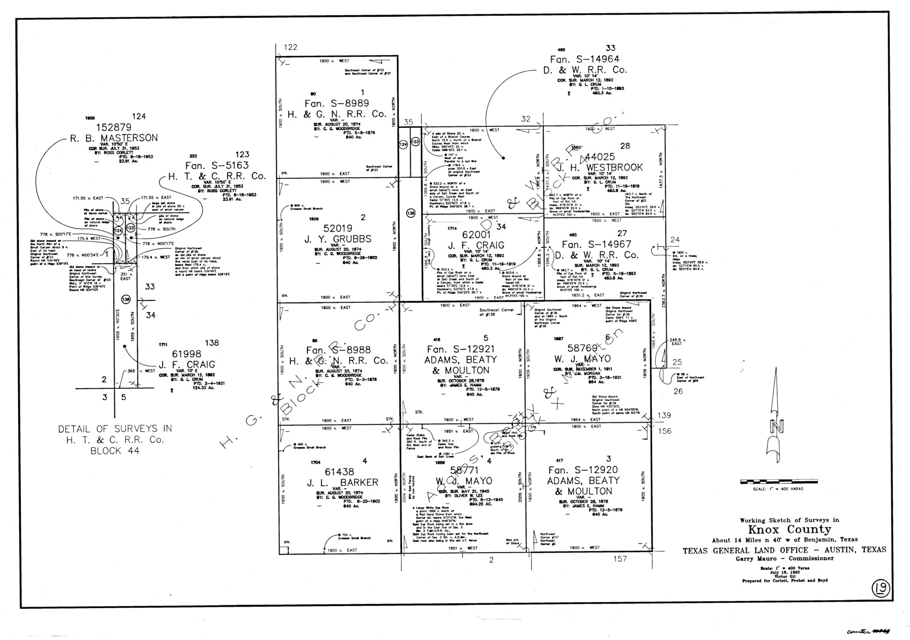
Knox County Working Sketch 19
-
Map/Doc
70261
-
Collection
General Map Collection
-
Object Dates
7/16/1992 (Creation Date)
-
People and Organizations
Victor Gil (Draftsman)
-
Counties
Knox
-
Subjects
Surveying Working Sketch
-
Height x Width
25.0 x 35.6 inches
63.5 x 90.4 cm
-
Scale
1" = 400 varas
Part of: General Map Collection
Travis County Boundary File 30

Print $4.00
- Digital $50.00
Travis County Boundary File 30
Size 10.4 x 8.6 inches
Map/Doc 59469
Bee County Sketch File 30

Print $6.00
- Digital $50.00
Bee County Sketch File 30
Size 14.2 x 8.9 inches
Map/Doc 14341
Starr County Rolled Sketch 17

Print $20.00
- Digital $50.00
Starr County Rolled Sketch 17
1911
Size 26.4 x 23.1 inches
Map/Doc 7802
Rio Grande, Mercedes and La Feria Sheet

Print $20.00
- Digital $50.00
Rio Grande, Mercedes and La Feria Sheet
1937
Size 37.3 x 37.2 inches
Map/Doc 65126
Flight Mission No. BQY-15M, Frame 21, Harris County

Print $20.00
- Digital $50.00
Flight Mission No. BQY-15M, Frame 21, Harris County
1953
Size 18.7 x 22.3 inches
Map/Doc 85319
A Map of the British Empire in America with the French and Spanish Settlements adjacent thereto

Print $20.00
- Digital $50.00
A Map of the British Empire in America with the French and Spanish Settlements adjacent thereto
1733
Size 20.7 x 20.6 inches
Map/Doc 95704
Webb County Working Sketch 55

Print $40.00
- Digital $50.00
Webb County Working Sketch 55
1955
Size 15.9 x 53.2 inches
Map/Doc 72421
Polk County Working Sketch 33b

Print $20.00
- Digital $50.00
Polk County Working Sketch 33b
1960
Size 14.9 x 24.8 inches
Map/Doc 71650
Marion County Working Sketch 14

Print $20.00
- Digital $50.00
Marion County Working Sketch 14
1956
Size 25.1 x 25.0 inches
Map/Doc 70790
South Sulphur River, Harpers Crossing Sheet

Print $20.00
- Digital $50.00
South Sulphur River, Harpers Crossing Sheet
1925
Size 42.2 x 29.2 inches
Map/Doc 65169
Hemphill County Working Sketch 14

Print $20.00
- Digital $50.00
Hemphill County Working Sketch 14
1969
Size 34.0 x 44.8 inches
Map/Doc 66109
Hunt County Rolled Sketch 4

Print $209.00
- Digital $50.00
Hunt County Rolled Sketch 4
1959
Size 10.4 x 15.2 inches
Map/Doc 45992
You may also like
General Highway Map, Ector County, Texas

Print $20.00
General Highway Map, Ector County, Texas
1940
Size 18.4 x 24.9 inches
Map/Doc 79081
Location of the Southern Kansas Railway of Texas

Print $40.00
- Digital $50.00
Location of the Southern Kansas Railway of Texas
1887
Size 19.0 x 103.2 inches
Map/Doc 64182
Tyler County Sketch File 1

Print $22.00
- Digital $50.00
Tyler County Sketch File 1
1849
Size 12.2 x 15.3 inches
Map/Doc 38607
Crane County Sketch File 3b

Print $20.00
- Digital $50.00
Crane County Sketch File 3b
1881
Size 11.9 x 38.6 inches
Map/Doc 11206
Fayette County

Print $40.00
- Digital $50.00
Fayette County
1978
Size 42.8 x 54.5 inches
Map/Doc 77278
Texas State Boundary Line 9

Print $174.00
Texas State Boundary Line 9
2000
Size 11.3 x 8.8 inches
Map/Doc 75076
Marion County Working Sketch 30

Print $20.00
- Digital $50.00
Marion County Working Sketch 30
1979
Size 31.7 x 38.3 inches
Map/Doc 70806

Pecos County Rolled Sketch 70A

Print $20.00
- Digital $50.00
Pecos County Rolled Sketch 70A
1929
Size 46.7 x 20.8 inches
Map/Doc 9709
Atascosa County

Print $20.00
- Digital $50.00
Atascosa County
1948
Size 47.6 x 44.9 inches
Map/Doc 77204
Flight Mission No. CGI-3N, Frame 144, Cameron County

Print $20.00
- Digital $50.00
Flight Mission No. CGI-3N, Frame 144, Cameron County
1954
Size 18.8 x 22.4 inches
Map/Doc 84617
Flight Mission No. CRC-2R, Frame 198, Chambers County

Print $20.00
- Digital $50.00
Flight Mission No. CRC-2R, Frame 198, Chambers County
1956
Size 18.7 x 22.4 inches
Map/Doc 84776