Houston Ship Channel, Alexander Island to Carpenter Bayou
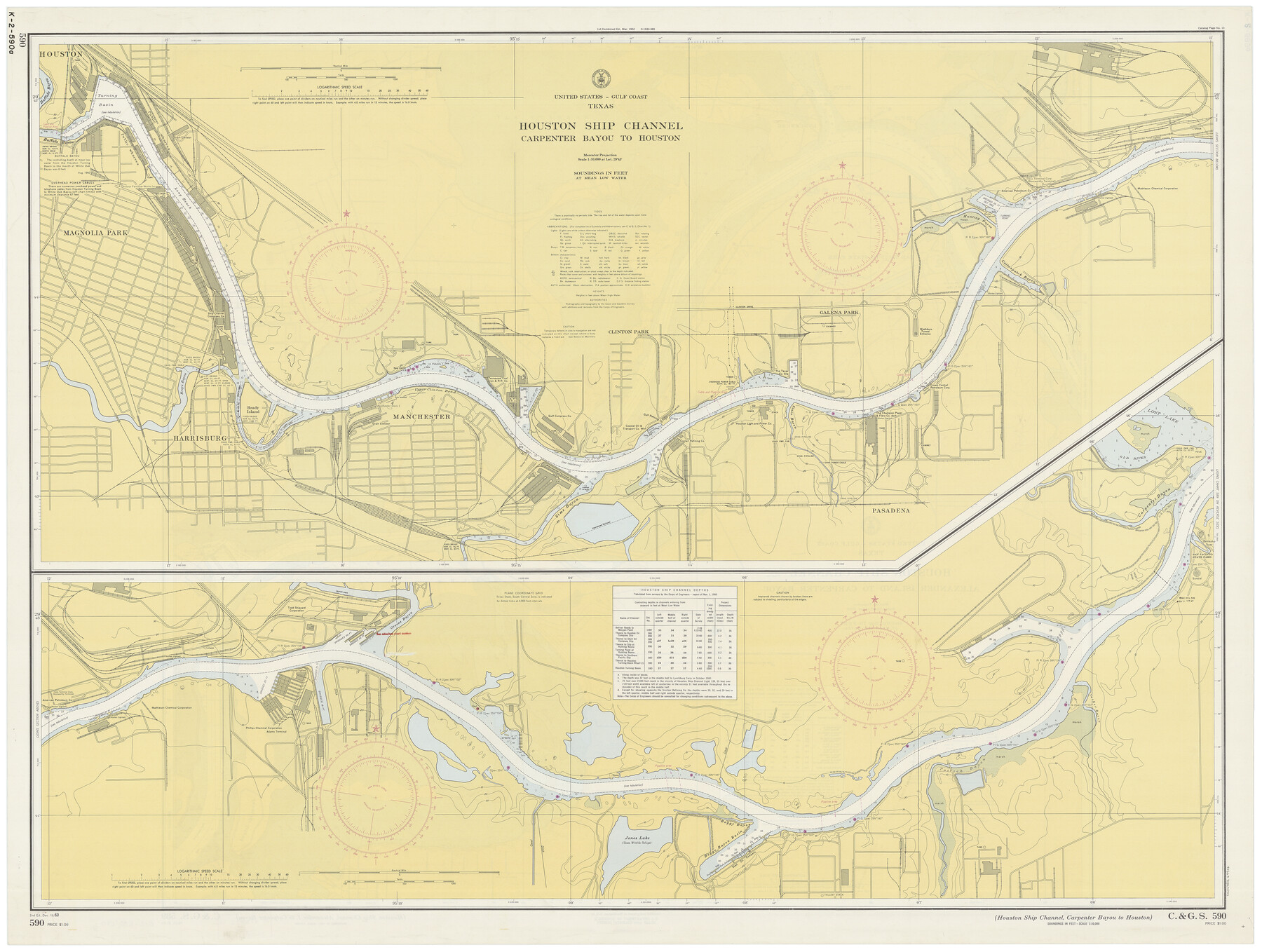
Houston Ship Channel, Carpenter Bayou to Houston
K-2-589; K-2-590
-
Map/Doc
69906
-
Collection
General Map Collection
-
Object Dates
12/19/1960 (Creation Date)
-
Counties
Harris
-
Subjects
Nautical Charts
-
Height x Width
34.8 x 46.2 inches
88.4 x 117.4 cm
-
Comments
dual-sided map
Part of: General Map Collection
Bandera County Sketch File 5

Print $4.00
- Digital $50.00
Bandera County Sketch File 5
Size 8.6 x 6.8 inches
Map/Doc 14003
Blanco County Sketch File 11

Print $4.00
- Digital $50.00
Blanco County Sketch File 11
Size 4.0 x 7.6 inches
Map/Doc 14590
Goliad County Working Sketch 9

Print $20.00
- Digital $50.00
Goliad County Working Sketch 9
1938
Size 19.3 x 27.6 inches
Map/Doc 63199
Brewster County Working Sketch 24

Print $20.00
- Digital $50.00
Brewster County Working Sketch 24
1939
Size 17.2 x 42.1 inches
Map/Doc 67558
[Map of the City of Austin]
![4802, [Map of the City of Austin], General Map Collection](https://historictexasmaps.com/wmedia_w700/maps/4802-1.tif.jpg)
Print $20.00
- Digital $50.00
[Map of the City of Austin]
1856
Size 29.1 x 21.5 inches
Map/Doc 4802
Nolan County Sketch File 1a

Print $20.00
- Digital $50.00
Nolan County Sketch File 1a
1882
Size 20.7 x 39.4 inches
Map/Doc 10554
Madison County Working Sketch 7

Print $20.00
- Digital $50.00
Madison County Working Sketch 7
1982
Size 12.7 x 17.4 inches
Map/Doc 70769
Crockett County Working Sketch 44

Print $20.00
- Digital $50.00
Crockett County Working Sketch 44
1933
Size 34.2 x 17.4 inches
Map/Doc 68377
Harris County NRC Article 33.136 Sketch 12

Print $30.00
- Digital $50.00
Harris County NRC Article 33.136 Sketch 12
2007
Size 24.0 x 17.5 inches
Map/Doc 94627
Kimble County Working Sketch 29

Print $20.00
- Digital $50.00
Kimble County Working Sketch 29
1941
Size 24.7 x 15.3 inches
Map/Doc 70097
Brazoria County NRC Article 33.136 Sketch 26

Print $24.00
Brazoria County NRC Article 33.136 Sketch 26
2025
Map/Doc 97471
Eastland County Working Sketch 49

Print $20.00
- Digital $50.00
Eastland County Working Sketch 49
1981
Size 29.0 x 24.6 inches
Map/Doc 68830
You may also like
Potter County Working Sketch 1

Print $20.00
- Digital $50.00
Potter County Working Sketch 1
Size 16.3 x 17.2 inches
Map/Doc 71661
Salado, South of Milam

Print $2.00
- Digital $50.00
Salado, South of Milam
1847
Size 11.4 x 8.5 inches
Map/Doc 359
Terrell County Working Sketch 82

Print $20.00
- Digital $50.00
Terrell County Working Sketch 82
1991
Size 31.7 x 24.8 inches
Map/Doc 69603
Houston County State Real Property Sketch 1

Print $20.00
- Digital $50.00
Houston County State Real Property Sketch 1
1997
Size 35.5 x 24.4 inches
Map/Doc 80129
The Republic County of Fort Bend. December 29, 1845

Print $20.00
The Republic County of Fort Bend. December 29, 1845
2020
Size 14.7 x 21.6 inches
Map/Doc 96142
Flight Mission No. CUG-1P, Frame 170, Kleberg County

Print $20.00
- Digital $50.00
Flight Mission No. CUG-1P, Frame 170, Kleberg County
1956
Size 18.5 x 22.2 inches
Map/Doc 86177
Rusk County Sketch File 39

Print $6.00
Rusk County Sketch File 39
1951
Size 11.3 x 8.9 inches
Map/Doc 35579
Navarro County Boundary File 1

Print $66.00
- Digital $50.00
Navarro County Boundary File 1
Size 10.3 x 8.2 inches
Map/Doc 57582
Flight Mission No. CGN-3P, Frame 142, San Patricio County

Print $20.00
- Digital $50.00
Flight Mission No. CGN-3P, Frame 142, San Patricio County
1956
Size 18.5 x 22.1 inches
Map/Doc 86986
Terrell County Sketch File 37

Print $4.00
- Digital $50.00
Terrell County Sketch File 37
Size 14.5 x 9.1 inches
Map/Doc 37999
General Highway Map, Atascosa County, Texas

Print $20.00
General Highway Map, Atascosa County, Texas
1940
Size 18.5 x 25.0 inches
Map/Doc 79007
Newton County Working Sketch 18

Print $20.00
- Digital $50.00
Newton County Working Sketch 18
1950
Size 14.3 x 13.6 inches
Map/Doc 71264