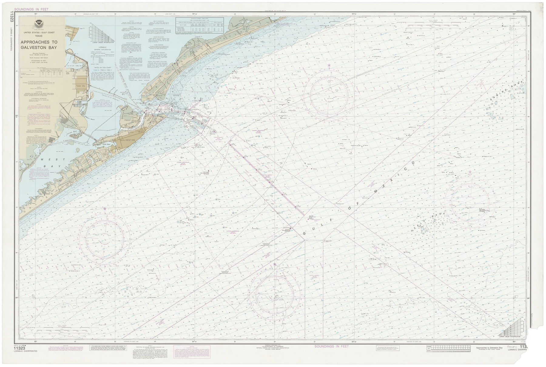
Approaches to Galveston Bay
K-6-1282i
- 
                          Map/Doc69886
- 
                            CollectionGeneral Map Collection
- 
                            Object Dates11/8/1986 (Creation Date)
- 
                            CountiesGalveston
- 
                            SubjectsNautical Charts
- 
                            Height x Width36.8 x 54.8 inches93.5 x 139.2 cm
Part of: General Map Collection
            Ownership Map of McCulloch County, Texas


                                            Print $20.00                    
                                             -                         Digital $50.00                                    
                Ownership Map of McCulloch County, Texas
1951
Size 40.5 x 32.5 inches
                                Map/Doc 3138
            
            Gillespie County Rolled Sketch 10


                                            Print $3.00                    
                                             -                         Digital $50.00                                    
                Gillespie County Rolled Sketch 10
2017
Size 16.1 x 10.7 inches
                                Map/Doc 94413
            
            Victoria County Rolled Sketch 7


                                            Print $40.00                    
                                             -                         Digital $50.00                                    
                Victoria County Rolled Sketch 7
1945
Size 54.2 x 16.3 inches
                                Map/Doc 10098
            
            Knox County Sketch File 26


                                            Print $40.00                    
                                             -                         Digital $50.00                                    
                Knox County Sketch File 26
1957
Size 17.3 x 14.4 inches
                                Map/Doc 29262
            
            Jefferson County Working Sketch 25


                                            Print $20.00                    
                                             -                         Digital $50.00                                    
                Jefferson County Working Sketch 25
1977
Size 39.8 x 43.4 inches
                                Map/Doc 66568
            
            Brazoria County Rolled Sketch 25


                                            Print $40.00                    
                                             -                         Digital $50.00                                    
                Brazoria County Rolled Sketch 25
1935
Size 50.8 x 33.5 inches
                                Map/Doc 8928
            
            Jones County Sketch File 17


                                            Print $20.00                    
                                             -                         Digital $50.00                                    
                Jones County Sketch File 17
1910
Size 17.2 x 29.4 inches
                                Map/Doc 11902
            
            Pecos County Sketch File 83


                                            Print $6.00                    
                                             -                         Digital $50.00                                    
                Pecos County Sketch File 83
1884
Size 11.3 x 8.7 inches
                                Map/Doc 33950
            
            Burleson County Sketch File 5


                                            Print $4.00                    
                                             -                         Digital $50.00                                    
                Burleson County Sketch File 5
Size 12.9 x 8.3 inches
                                Map/Doc 16649
            
            Panola County Working Sketch 27


                                            Print $20.00                    
                                             -                         Digital $50.00                                    
                Panola County Working Sketch 27
1956
Map/Doc 71436
            
            Orange County Working Sketch 33


                                            Print $20.00                    
                                             -                         Digital $50.00                                    
                Orange County Working Sketch 33
1957
Size 26.1 x 18.4 inches
                                Map/Doc 71365
            You may also like
            The Making of America - The Southwest


            The Making of America - The Southwest
Size 20.8 x 27.5 inches
                                Map/Doc 95947
            
            J. De Cordova's Map of the State of Texas Compiled from the records of the General Land Office of the State


                                            Print $20.00                    
                                    
                J. De Cordova's Map of the State of Texas Compiled from the records of the General Land Office of the State
1856
Size 34.2 x 32.1 inches
                                Map/Doc 76222
            
            Kerr County Rolled Sketch 11


                                            Print $20.00                    
                                             -                         Digital $50.00                                    
                Kerr County Rolled Sketch 11
1950
Size 28.1 x 36.9 inches
                                Map/Doc 6495
            
            [H. & G. N. Block 1]
            
                                    ![90943, [H. & G. N. Block 1], Twichell Survey Records](https://historictexasmaps.com/wmedia_w700/maps/90943-1.tif.jpg) 


    ![90943, [H. & G. N. Block 1], Twichell Survey Records](https://historictexasmaps.com/wmedia_w700/maps/90943-1.tif.jpg) 
                                
            
                                            Print $20.00                    
                                             -                         Digital $50.00                                    
                [H. & G. N. Block 1]
1873
Size 14.3 x 17.6 inches
                                Map/Doc 90943
            
            Haskell County Sketch File 16


                                            Print $32.00                    
                                             -                         Digital $50.00                                    
                Haskell County Sketch File 16
1894
Size 11.2 x 8.8 inches
                                Map/Doc 26163
            
            Flight Mission No. DAG-24K, Frame 133, Matagorda County


                                            Print $20.00                    
                                             -                         Digital $50.00                                    
                Flight Mission No. DAG-24K, Frame 133, Matagorda County
1953
Size 18.5 x 22.3 inches
                                Map/Doc 86551
            
            Liberty County Working Sketch 63


                                            Print $6.00                    
                                             -                         Digital $50.00                                    
                Liberty County Working Sketch 63
1969
Size 31.3 x 28.7 inches
                                Map/Doc 70523
            
            Treaty to Resolve Pending Boundary Differences and Maintain the Rio Grande and Colorado River as the International Boundary Between the United States of American and Mexico


                                            Print $4.00                    
                                             -                         Digital $50.00                                    
                Treaty to Resolve Pending Boundary Differences and Maintain the Rio Grande and Colorado River as the International Boundary Between the United States of American and Mexico
1970
Size 10.9 x 18.1 inches
                                Map/Doc 83101
            
            Irion County Rolled Sketch 7


                                            Print $20.00                    
                                             -                         Digital $50.00                                    
                Irion County Rolled Sketch 7
Size 43.9 x 33.8 inches
                                Map/Doc 9250
            
            Map of Galveston Bay from Lawrence Cove to Stevenson's Station


                                            Print $20.00                    
                                             -                         Digital $50.00                                    
                Map of Galveston Bay from Lawrence Cove to Stevenson's Station
1851
Size 41.5 x 30.0 inches
                                Map/Doc 69922
            
            Montague County Sketch File 16


                                            Print $20.00                    
                                             -                         Digital $50.00                                    
                Montague County Sketch File 16
1853
Size 32.5 x 29.2 inches
                                Map/Doc 10546
             
                         
                                