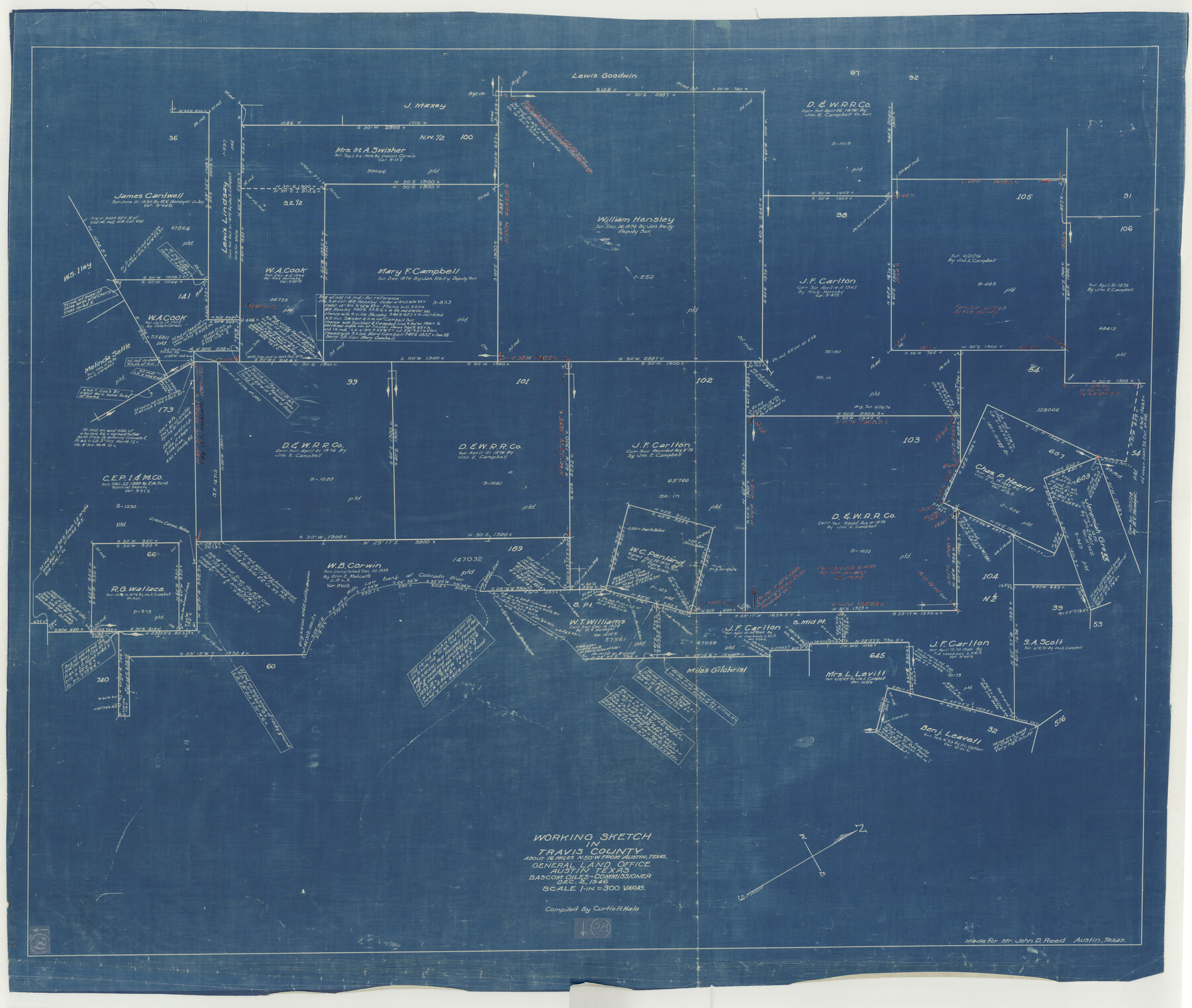
Travis County Working Sketch 58
-
Map/Doc
69442
-
Collection
General Map Collection
-
Object Dates
12/2/1946 (Creation Date)
-
People and Organizations
Curtis R. Hale (Draftsman)
-
Counties
Travis
-
Subjects
Surveying Working Sketch
-
Height x Width
36.4 x 43.0 inches
92.5 x 109.2 cm
-
Scale
1" = 300 varas
Part of: General Map Collection
Aransas County Working Sketch 8

Print $20.00
- Digital $50.00
Aransas County Working Sketch 8
1947
Size 24.7 x 24.2 inches
Map/Doc 67175
La Salle County Sketch File 39

Print $6.00
- Digital $50.00
La Salle County Sketch File 39
1912
Size 16.4 x 11.4 inches
Map/Doc 29592
Burnet County Boundary File 12b

Print $8.00
- Digital $50.00
Burnet County Boundary File 12b
Size 12.8 x 8.4 inches
Map/Doc 50960
Guadalupe County Sketch File 16

Print $22.00
- Digital $50.00
Guadalupe County Sketch File 16
Size 15.7 x 12.4 inches
Map/Doc 24694
Rio Grande, Mercedes and La Feria Sheet

Print $20.00
- Digital $50.00
Rio Grande, Mercedes and La Feria Sheet
1937
Size 37.3 x 37.2 inches
Map/Doc 65126
Kinney County Sketch File 28

Print $8.00
- Digital $50.00
Kinney County Sketch File 28
1929
Size 11.3 x 9.0 inches
Map/Doc 29167
Falls County Sketch File 31

Print $4.00
- Digital $50.00
Falls County Sketch File 31
1881
Size 14.5 x 8.8 inches
Map/Doc 22439
Real County Working Sketch 65

Print $20.00
- Digital $50.00
Real County Working Sketch 65
1969
Size 31.1 x 23.4 inches
Map/Doc 71957
Scurry County Rolled Sketch 8

Print $20.00
- Digital $50.00
Scurry County Rolled Sketch 8
1949
Size 35.1 x 19.1 inches
Map/Doc 7768
Sterling County Sketch File 12

Print $20.00
- Digital $50.00
Sterling County Sketch File 12
1930
Size 14.4 x 28.4 inches
Map/Doc 12358
Jefferson County Rolled Sketch 50

Print $20.00
- Digital $50.00
Jefferson County Rolled Sketch 50
Size 34.2 x 41.6 inches
Map/Doc 9306
Flight Mission No. DQN-3K, Frame 9, Calhoun County

Print $20.00
- Digital $50.00
Flight Mission No. DQN-3K, Frame 9, Calhoun County
1953
Size 18.6 x 22.2 inches
Map/Doc 84341
You may also like
San Patricio County Sketch File 45

Print $20.00
- Digital $50.00
San Patricio County Sketch File 45
1943
Size 11.2 x 8.9 inches
Map/Doc 36273
Colorado County Working Sketch 25

Print $20.00
- Digital $50.00
Colorado County Working Sketch 25
1972
Size 39.1 x 34.2 inches
Map/Doc 68125
Marion County Working Sketch 10

Print $20.00
- Digital $50.00
Marion County Working Sketch 10
1949
Size 30.9 x 30.2 inches
Map/Doc 70785
Stonewall County

Print $20.00
- Digital $50.00
Stonewall County
1933
Size 47.6 x 39.5 inches
Map/Doc 73295
Bexar County Working Sketch 14

Print $20.00
- Digital $50.00
Bexar County Working Sketch 14
1971
Size 35.2 x 37.7 inches
Map/Doc 67330
Pecos County Rolled Sketch 157

Print $233.00
- Digital $50.00
Pecos County Rolled Sketch 157
1962
Size 10.5 x 15.3 inches
Map/Doc 48558

Brewster County Working Sketch 108

Print $20.00
- Digital $50.00
Brewster County Working Sketch 108
1981
Size 37.7 x 47.6 inches
Map/Doc 67708
Webb County Sketch File Z

Print $20.00
- Digital $50.00
Webb County Sketch File Z
1901
Size 16.8 x 22.2 inches
Map/Doc 12610
Cherokee County Sketch File 25

Print $4.00
- Digital $50.00
Cherokee County Sketch File 25
1852
Size 12.8 x 8.1 inches
Map/Doc 18167
[Blocks M19, M3 & M20]
![91819, [Blocks M19, M3 & M20], Twichell Survey Records](https://historictexasmaps.com/wmedia_w700/maps/91819-1.tif.jpg)
Print $20.00
- Digital $50.00
[Blocks M19, M3 & M20]
Size 47.3 x 20.0 inches
Map/Doc 91819
Entrance to Sabine Pass, Texas from survey of May and June 1892 under the direction of Major James B. Quinn, Corps of Engineers, USA

Print $20.00
- Digital $50.00
Entrance to Sabine Pass, Texas from survey of May and June 1892 under the direction of Major James B. Quinn, Corps of Engineers, USA
1892
Size 18.8 x 32.9 inches
Map/Doc 94154