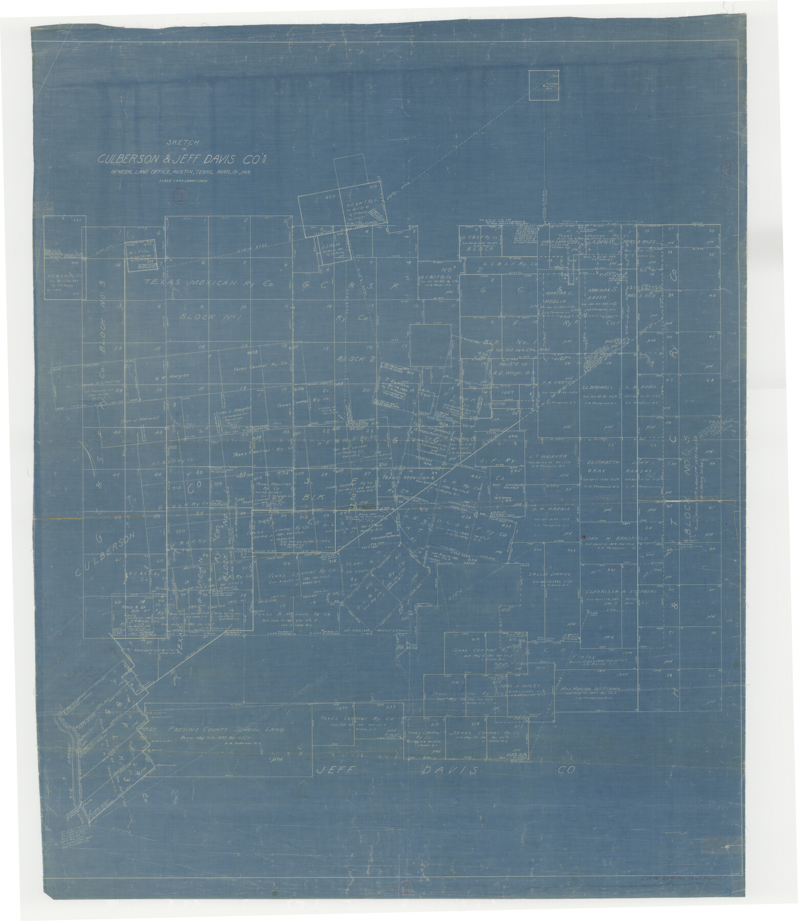
Culberson County Working Sketch 9
-
Map/Doc
68461
-
Collection
General Map Collection
-
Object Dates
3/19/1915 (Creation Date)
-
Counties
Culberson Jeff Davis
-
Subjects
Surveying Working Sketch
-
Height x Width
41.5 x 35.9 inches
105.4 x 91.2 cm
-
Scale
1" = 1000 varas
Part of: General Map Collection
Parker County Working Sketch Graphic Index

Print $20.00
- Digital $50.00
Parker County Working Sketch Graphic Index
1942
Map/Doc 76661
[Galveston, Harrisburg & San Antonio Railroad from Cuero to Stockdale]
![64196, [Galveston, Harrisburg & San Antonio Railroad from Cuero to Stockdale], General Map Collection](https://historictexasmaps.com/wmedia_w700/maps/64196.tif.jpg)
Print $20.00
- Digital $50.00
[Galveston, Harrisburg & San Antonio Railroad from Cuero to Stockdale]
1907
Size 13.7 x 34.0 inches
Map/Doc 64196
Sherman County Rolled Sketch 12

Print $40.00
- Digital $50.00
Sherman County Rolled Sketch 12
1951
Size 11.5 x 64.0 inches
Map/Doc 9931
Polk County Working Sketch 3

Print $40.00
- Digital $50.00
Polk County Working Sketch 3
1911
Size 25.4 x 56.0 inches
Map/Doc 71618
Cottle County

Print $20.00
- Digital $50.00
Cottle County
1908
Size 45.0 x 41.0 inches
Map/Doc 66789
Trinity County Rolled Sketch 8

Print $20.00
- Digital $50.00
Trinity County Rolled Sketch 8
Size 44.2 x 35.4 inches
Map/Doc 83177
Baylor County Sketch File 12g

Print $50.00
- Digital $50.00
Baylor County Sketch File 12g
Size 11.4 x 8.9 inches
Map/Doc 14170
Jefferson County Rolled Sketch 29

Print $20.00
- Digital $50.00
Jefferson County Rolled Sketch 29
1952
Size 31.8 x 43.6 inches
Map/Doc 9293
Frio County Working Sketch 28

Print $20.00
- Digital $50.00
Frio County Working Sketch 28
2006
Size 40.8 x 42.0 inches
Map/Doc 83605
Greer County Sketch File 10

Print $4.00
- Digital $50.00
Greer County Sketch File 10
1929
Size 8.6 x 13.4 inches
Map/Doc 24530
Loving County Working Sketch 24

Print $40.00
- Digital $50.00
Loving County Working Sketch 24
1952
Size 15.8 x 63.3 inches
Map/Doc 70658
Val Verde County Sketch File AA3

Print $20.00
- Digital $50.00
Val Verde County Sketch File AA3
1924
Size 19.5 x 20.6 inches
Map/Doc 12540
You may also like
English Field Notes of the Spanish Archives - Book C

English Field Notes of the Spanish Archives - Book C
1835
Map/Doc 96541
Grayson County Working Sketch 9

Print $20.00
- Digital $50.00
Grayson County Working Sketch 9
1946
Size 44.8 x 31.7 inches
Map/Doc 63248

Angelina County Working Sketch 23

Print $20.00
- Digital $50.00
Angelina County Working Sketch 23
1953
Size 19.8 x 32.6 inches
Map/Doc 67105

Hardeman County Rolled Sketch 23

Print $20.00
- Digital $50.00
Hardeman County Rolled Sketch 23
1952
Size 34.6 x 30.8 inches
Map/Doc 10671
Karnes County, Texas

Print $20.00
- Digital $50.00
Karnes County, Texas
1880
Size 28.9 x 23.0 inches
Map/Doc 524
Wood County Working Sketch 21

Print $20.00
- Digital $50.00
Wood County Working Sketch 21
1962
Size 40.6 x 35.7 inches
Map/Doc 62021
Map of the City of Barry, John McGowan & J.B. & A. Adams Surveys, Navarro County, Texas

Print $20.00
- Digital $50.00
Map of the City of Barry, John McGowan & J.B. & A. Adams Surveys, Navarro County, Texas
1958
Size 28.4 x 25.4 inches
Map/Doc 94015
Railroad and County Map of Texas

Print $20.00
Railroad and County Map of Texas
1893
Size 24.2 x 27.2 inches
Map/Doc 76255
Schleicher County Rolled Sketch 13

Print $20.00
- Digital $50.00
Schleicher County Rolled Sketch 13
Size 37.2 x 30.8 inches
Map/Doc 7756
Flight Mission No. BRE-1P, Frame 144, Nueces County

Print $20.00
- Digital $50.00
Flight Mission No. BRE-1P, Frame 144, Nueces County
1956
Size 18.3 x 22.3 inches
Map/Doc 86704