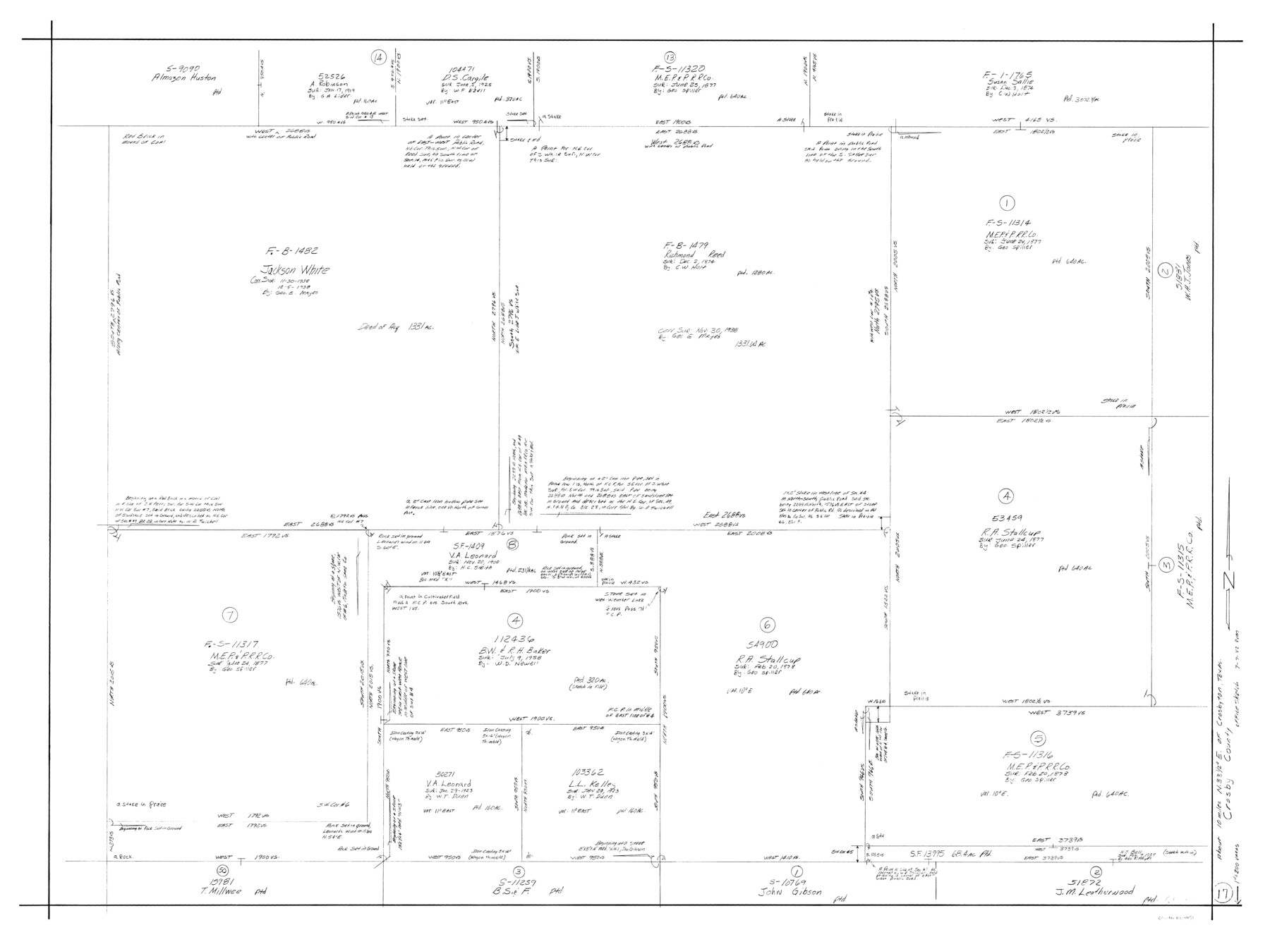
Crosby County Working Sketch 17
-
Map/Doc
68451
-
Collection
General Map Collection
-
Object Dates
7/7/1982 (Creation Date)
-
People and Organizations
Rosendo V. Molina (Draftsman)
-
Counties
Crosby
-
Subjects
Surveying Working Sketch
-
Height x Width
32.8 x 43.9 inches
83.3 x 111.5 cm
-
Scale
1" = 200 varas
Part of: General Map Collection
Harrison County Sketch File 10

Print $4.00
- Digital $50.00
Harrison County Sketch File 10
Size 7.7 x 8.0 inches
Map/Doc 26050
Edwards County Working Sketch 11

Print $20.00
- Digital $50.00
Edwards County Working Sketch 11
1922
Size 18.8 x 31.7 inches
Map/Doc 68887
Pecos County Working Sketch 17

Print $20.00
- Digital $50.00
Pecos County Working Sketch 17
1915
Size 32.5 x 23.0 inches
Map/Doc 71487
Frio County Rolled Sketch 10

Print $20.00
- Digital $50.00
Frio County Rolled Sketch 10
1945
Size 34.0 x 35.7 inches
Map/Doc 8902
Chambers County Rolled Sketch 31

Print $20.00
- Digital $50.00
Chambers County Rolled Sketch 31
1952
Size 32.3 x 32.0 inches
Map/Doc 8620
[St. L. S-W. Ry. Of Texas Map of Lufkin Branch in Cherokee County Texas]
![64022, [St. L. S-W. Ry. Of Texas Map of Lufkin Branch in Cherokee County Texas], General Map Collection](https://historictexasmaps.com/wmedia_w700/maps/64022.tif.jpg)
Print $40.00
- Digital $50.00
[St. L. S-W. Ry. Of Texas Map of Lufkin Branch in Cherokee County Texas]
1912
Size 23.1 x 122.7 inches
Map/Doc 64022
[Sketch for Mineral Application 26501 - Sabine River, T. A. Oldhausen]
![2840, [Sketch for Mineral Application 26501 - Sabine River, T. A. Oldhausen], General Map Collection](https://historictexasmaps.com/wmedia_w700/maps/2840.tif.jpg)
Print $20.00
- Digital $50.00
[Sketch for Mineral Application 26501 - Sabine River, T. A. Oldhausen]
1931
Size 24.3 x 35.5 inches
Map/Doc 2840
Reagan County Working Sketch 16

Print $20.00
- Digital $50.00
Reagan County Working Sketch 16
1950
Size 24.5 x 42.5 inches
Map/Doc 71858
Howard County State Real Property Sketch 1

Print $40.00
- Digital $50.00
Howard County State Real Property Sketch 1
2007
Size 24.3 x 35.2 inches
Map/Doc 88673
Fayette County Boundary File 4

Print $19.00
- Digital $50.00
Fayette County Boundary File 4
Size 14.4 x 9.0 inches
Map/Doc 53362
Matagorda County NRC Article 33.136 Sketch 17

Print $24.00
Matagorda County NRC Article 33.136 Sketch 17
2023
Map/Doc 97274
Edwards County

Print $40.00
- Digital $50.00
Edwards County
1900
Size 56.3 x 59.5 inches
Map/Doc 66810
You may also like
Dawson County Sketch File 28

Print $20.00
- Digital $50.00
Dawson County Sketch File 28
1961
Size 46.0 x 15.3 inches
Map/Doc 10362
Cass County Working Sketch 29

Print $20.00
- Digital $50.00
Cass County Working Sketch 29
1979
Size 38.4 x 23.5 inches
Map/Doc 67932
Karnes County Working Sketch 8

Print $40.00
- Digital $50.00
Karnes County Working Sketch 8
1962
Size 51.8 x 36.0 inches
Map/Doc 66656
Eastland County Working Sketch 9

Print $20.00
- Digital $50.00
Eastland County Working Sketch 9
1919
Size 33.0 x 30.6 inches
Map/Doc 68790
Map of Colorado County

Print $20.00
- Digital $50.00
Map of Colorado County
1880
Size 21.8 x 21.1 inches
Map/Doc 3426
Pecos County Working Sketch 41

Print $20.00
- Digital $50.00
Pecos County Working Sketch 41
1942
Size 19.0 x 31.7 inches
Map/Doc 71513

Goliad County Sketch File 3

Print $4.00
- Digital $50.00
Goliad County Sketch File 3
1852
Size 12.4 x 8.2 inches
Map/Doc 24214
San Antonio & Aransas Pass R.R. Right of Way from Eagle Lake to Brazos River

Print $20.00
- Digital $50.00
San Antonio & Aransas Pass R.R. Right of Way from Eagle Lake to Brazos River
1895
Size 29.7 x 13.0 inches
Map/Doc 64257
State Land For Sale On Mustang Island by General Land Office

Print $20.00
- Digital $50.00
State Land For Sale On Mustang Island by General Land Office
1910
Size 21.7 x 17.5 inches
Map/Doc 385
The Republic County of Lamar. January 28, 1841

Print $20.00
The Republic County of Lamar. January 28, 1841
2020
Size 16.4 x 21.7 inches
Map/Doc 96203
Starr County Working Sketch 24

Print $20.00
- Digital $50.00
Starr County Working Sketch 24
1988
Size 37.1 x 20.2 inches
Map/Doc 63940