Menard County Rolled Sketch 9
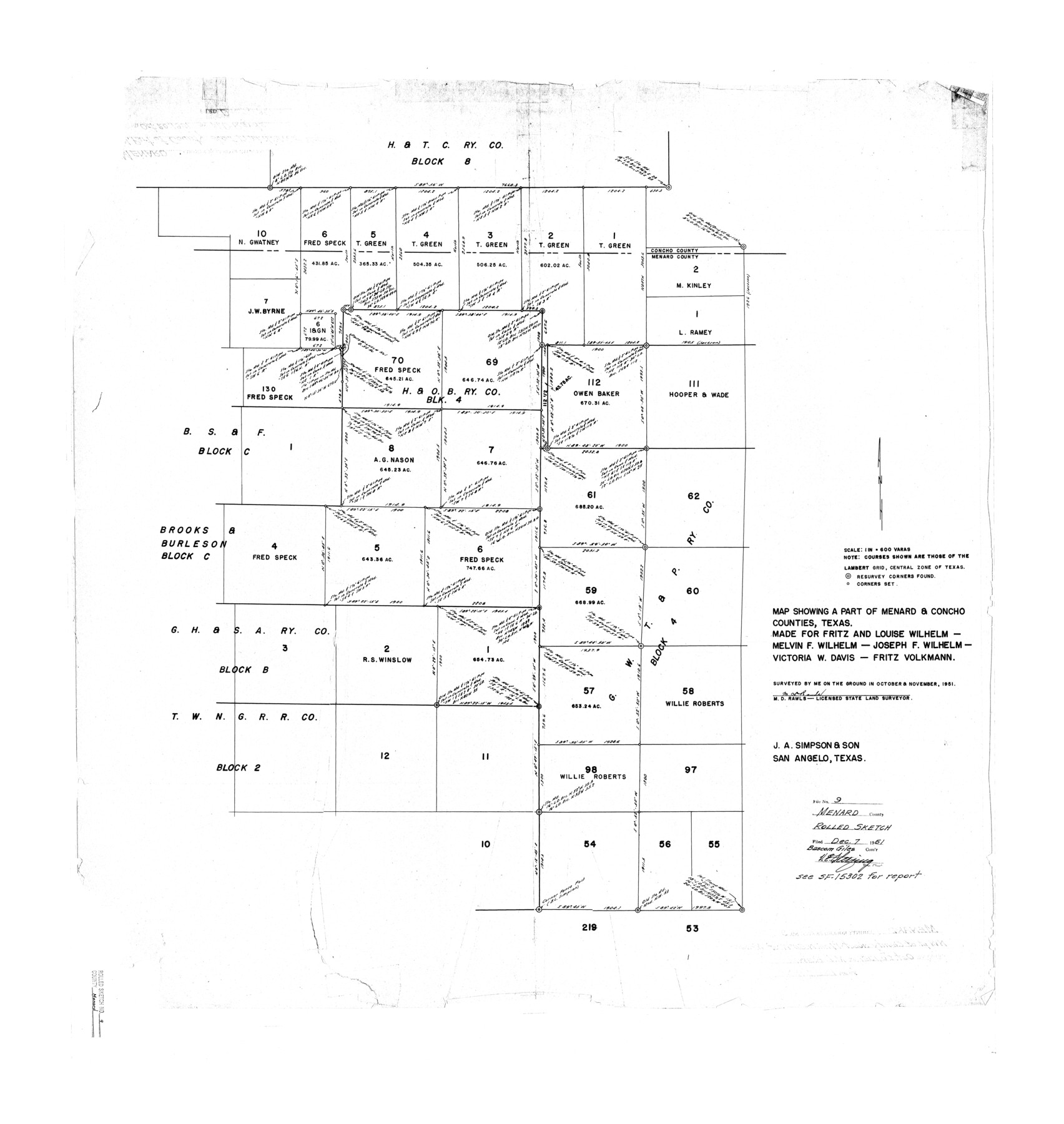
Map showing a part of Menard & Concho Counties, Texas made for Fritz and Louise Wilhelm - Melvin F. Wilhelm - Joseph F. Wilhelm - Victoria W. Davis - Fritz Volkmann
-
Map/Doc
6756
-
Collection
General Map Collection
-
Object Dates
1951 (Survey Date)
1951/12/7 (File Date)
-
People and Organizations
M.D. Rawls (Surveyor/Engineer)
-
Counties
Menard Concho
-
Subjects
Surveying Rolled Sketch
-
Height x Width
36.0 x 34.1 inches
91.4 x 86.6 cm
-
Scale
1" = 600 varas
-
Comments
See SF-15302 for report.
Part of: General Map Collection
Colorado County Working Sketch 8

Print $20.00
- Digital $50.00
Colorado County Working Sketch 8
1937
Size 19.7 x 21.0 inches
Map/Doc 68108
Victoria County Rolled Sketch 6

Print $20.00
- Digital $50.00
Victoria County Rolled Sketch 6
Size 27.9 x 36.3 inches
Map/Doc 8152
Harris County Rolled Sketch 7b

Print $20.00
- Digital $50.00
Harris County Rolled Sketch 7b
Size 47.8 x 42.4 inches
Map/Doc 9853
San Patricio County Rolled Sketch 20

Print $20.00
- Digital $50.00
San Patricio County Rolled Sketch 20
1953
Size 37.6 x 31.9 inches
Map/Doc 7578
Flight Mission No. BRA-8M, Frame 85, Jefferson County

Print $20.00
- Digital $50.00
Flight Mission No. BRA-8M, Frame 85, Jefferson County
1953
Size 18.7 x 22.3 inches
Map/Doc 85605
Kimble County Sketch File 29 and 30

Print $28.00
- Digital $50.00
Kimble County Sketch File 29 and 30
1936
Size 15.4 x 24.6 inches
Map/Doc 11928
Nueces County Rolled Sketch 76

Print $20.00
- Digital $50.00
Nueces County Rolled Sketch 76
1981
Size 18.3 x 23.6 inches
Map/Doc 6937
Navarro County Sketch File 17

Print $4.00
- Digital $50.00
Navarro County Sketch File 17
Size 12.8 x 8.4 inches
Map/Doc 32333
Map of San Leon, Amos Edwards League, Galveston County, Texas

Print $20.00
- Digital $50.00
Map of San Leon, Amos Edwards League, Galveston County, Texas
1911
Size 22.9 x 14.1 inches
Map/Doc 3037
Map of the City of Austin Texas

Map of the City of Austin Texas
1933
Size 22.5 x 17.6 inches
Map/Doc 76050
Brown County Sketch File 8

Print $4.00
- Digital $50.00
Brown County Sketch File 8
1860
Size 13.4 x 8.1 inches
Map/Doc 16593
Upton County Rolled Sketch 19

Print $40.00
- Digital $50.00
Upton County Rolled Sketch 19
1933
Size 55.2 x 40.0 inches
Map/Doc 10040
You may also like
Brewster County Working Sketch 72

Print $20.00
- Digital $50.00
Brewster County Working Sketch 72
1965
Size 20.7 x 24.6 inches
Map/Doc 67672
Dawson County Working Sketch 8

Print $20.00
- Digital $50.00
Dawson County Working Sketch 8
1943
Size 15.3 x 15.4 inches
Map/Doc 68552
Flight Mission No. BQY-4M, Frame 53, Harris County

Print $20.00
- Digital $50.00
Flight Mission No. BQY-4M, Frame 53, Harris County
1953
Size 18.6 x 22.3 inches
Map/Doc 85262
Flight Mission No. DIX-6P, Frame 198, Aransas County

Print $20.00
- Digital $50.00
Flight Mission No. DIX-6P, Frame 198, Aransas County
1956
Size 19.1 x 22.9 inches
Map/Doc 83860
The Great Lakes Region of the United States and Canada

The Great Lakes Region of the United States and Canada
1953
Size 42.5 x 28.6 inches
Map/Doc 92396
Lampasas County Working Sketch 11

Print $20.00
- Digital $50.00
Lampasas County Working Sketch 11
1964
Size 38.3 x 42.8 inches
Map/Doc 70288
Dimmit County Working Sketch Graphic Index - sheet B

Print $40.00
- Digital $50.00
Dimmit County Working Sketch Graphic Index - sheet B
1976
Size 41.5 x 49.9 inches
Map/Doc 76525
Sterling County

Print $20.00
- Digital $50.00
Sterling County
1971
Size 44.7 x 33.4 inches
Map/Doc 73294
Flight Mission No. DCL-7C, Frame 16, Kenedy County

Print $20.00
- Digital $50.00
Flight Mission No. DCL-7C, Frame 16, Kenedy County
1943
Size 15.2 x 15.4 inches
Map/Doc 86008
Flight Mission No. CRC-4R, Frame 153, Chambers County

Print $20.00
- Digital $50.00
Flight Mission No. CRC-4R, Frame 153, Chambers County
1956
Size 18.7 x 22.4 inches
Map/Doc 84916
Starr County Boundary File 44a

Print $57.00
- Digital $50.00
Starr County Boundary File 44a
Size 9.3 x 9.4 inches
Map/Doc 58827
Flight Mission No. DQN-7K, Frame 13, Calhoun County

Print $20.00
- Digital $50.00
Flight Mission No. DQN-7K, Frame 13, Calhoun County
1953
Size 18.4 x 22.1 inches
Map/Doc 84464