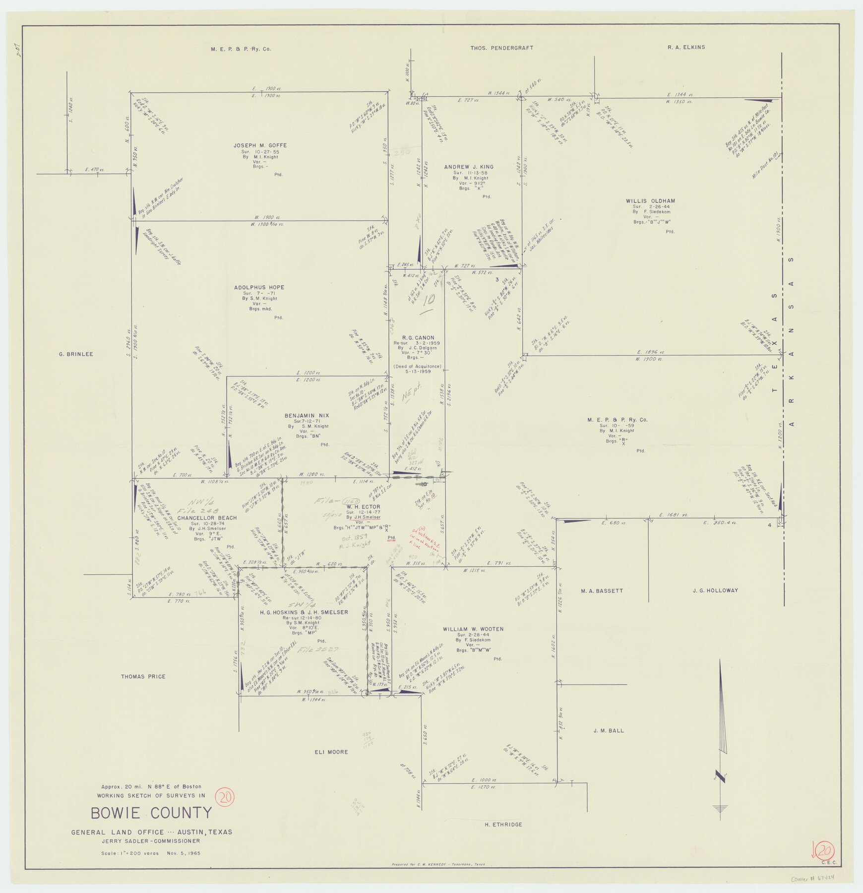
Bowie County Working Sketch 20
-
Map/Doc
67424
-
Collection
General Map Collection
-
Object Dates
11/5/1965 (Creation Date)
-
People and Organizations
Jerry Sadler (GLO Commissioner)
-
Counties
Bowie
-
Subjects
Surveying Working Sketch
-
Height x Width
33.0 x 31.9 inches
83.8 x 81.0 cm
-
Scale
1" = 200 varas
-
Comments
Surveys located about 20 miles North 88 degrees East of Boston, Texas.
Part of: General Map Collection
Neel's Creek of North Bosque

Print $2.00
- Digital $50.00
Neel's Creek of North Bosque
1847
Size 8.9 x 7.9 inches
Map/Doc 69755
Hemphill County

Print $20.00
- Digital $50.00
Hemphill County
1899
Size 43.0 x 36.4 inches
Map/Doc 4976
Sutton County Sketch File 36a

Print $61.00
- Digital $50.00
Sutton County Sketch File 36a
Size 9.0 x 9.0 inches
Map/Doc 37472
Burleson County Sketch File 7

Print $40.00
- Digital $50.00
Burleson County Sketch File 7
1935
Size 17.0 x 14.5 inches
Map/Doc 16653
Flight Mission No. DCL-6C, Frame 78, Kenedy County

Print $20.00
- Digital $50.00
Flight Mission No. DCL-6C, Frame 78, Kenedy County
1943
Size 17.5 x 20.7 inches
Map/Doc 85920
Hopkins County Sketch File 20

Print $4.00
- Digital $50.00
Hopkins County Sketch File 20
1871
Size 12.8 x 8.3 inches
Map/Doc 26725
Rusk County Sketch File 43

Print $20.00
Rusk County Sketch File 43
1951
Size 23.5 x 26.6 inches
Map/Doc 12278
Williamson County Sketch File 11

Print $4.00
- Digital $50.00
Williamson County Sketch File 11
Size 8.2 x 9.2 inches
Map/Doc 40324
Lavaca County Rolled Sketch 6

Print $20.00
- Digital $50.00
Lavaca County Rolled Sketch 6
1986
Size 44.8 x 33.9 inches
Map/Doc 10290
PSL Field Notes for Blocks 77 through 86 in Culberson County and Blocks 73 through 76 in Hudspeth County

PSL Field Notes for Blocks 77 through 86 in Culberson County and Blocks 73 through 76 in Hudspeth County
Map/Doc 81663
Hardin County Working Sketch 44

Print $40.00
- Digital $50.00
Hardin County Working Sketch 44
1954
Size 53.2 x 39.9 inches
Map/Doc 65610
1910 Map of the City of Houston and vicinity

Print $20.00
- Digital $50.00
1910 Map of the City of Houston and vicinity
1910
Size 20.5 x 23.4 inches
Map/Doc 97452
You may also like
Tyler County Working Sketch 23

Print $20.00
- Digital $50.00
Tyler County Working Sketch 23
1988
Size 28.2 x 22.8 inches
Map/Doc 69493
[Block 47, Sections 66-76]
![91790, [Block 47, Sections 66-76], Twichell Survey Records](https://historictexasmaps.com/wmedia_w700/maps/91790-1.tif.jpg)
Print $3.00
- Digital $50.00
[Block 47, Sections 66-76]
Size 15.8 x 10.6 inches
Map/Doc 91790
Motley County

Print $20.00
- Digital $50.00
Motley County
1966
Size 44.8 x 35.8 inches
Map/Doc 95597
Lamb County Boundary File 1a

Print $24.00
- Digital $50.00
Lamb County Boundary File 1a
Size 11.3 x 8.7 inches
Map/Doc 56032
Crockett County Sketch File 6

Print $20.00
- Digital $50.00
Crockett County Sketch File 6
1877
Size 22.2 x 17.2 inches
Map/Doc 3457
Borden County Working Sketch 2

Print $20.00
- Digital $50.00
Borden County Working Sketch 2
1913
Size 24.6 x 18.4 inches
Map/Doc 67462
Flight Mission No. BRE-1P, Frame 145, Nueces County

Print $20.00
- Digital $50.00
Flight Mission No. BRE-1P, Frame 145, Nueces County
1956
Size 18.4 x 22.1 inches
Map/Doc 86705
Leon County Working Sketch 50

Print $20.00
- Digital $50.00
Leon County Working Sketch 50
1981
Size 28.9 x 24.2 inches
Map/Doc 70449
Flight Mission No. DQN-7K, Frame 37, Calhoun County

Print $20.00
- Digital $50.00
Flight Mission No. DQN-7K, Frame 37, Calhoun County
1953
Size 18.4 x 22.1 inches
Map/Doc 84475
Coryell County Sketch File 25

Print $4.00
- Digital $50.00
Coryell County Sketch File 25
1873
Size 12.8 x 8.3 inches
Map/Doc 19391
Gregg County Working Sketch 14

Print $20.00
- Digital $50.00
Gregg County Working Sketch 14
1941
Size 29.7 x 39.5 inches
Map/Doc 63281
Flight Mission No. DQN-2K, Frame 159, Calhoun County

Print $20.00
- Digital $50.00
Flight Mission No. DQN-2K, Frame 159, Calhoun County
1953
Size 18.5 x 22.2 inches
Map/Doc 84321