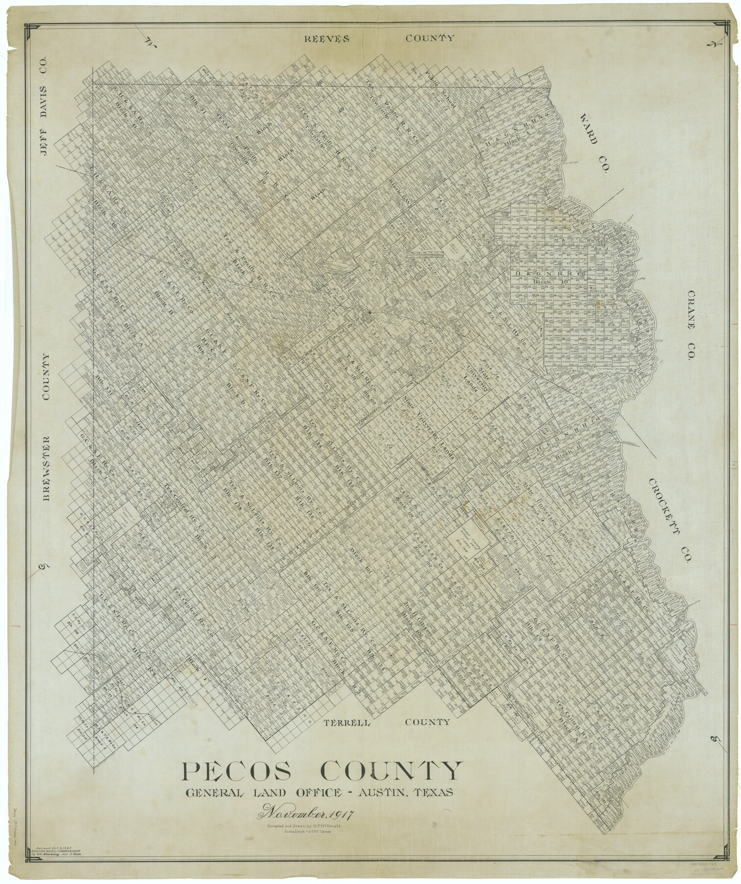
Pecos County
-
Map/Doc
66979
-
Collection
General Map Collection
-
Object Dates
1917 (Creation Date)
-
People and Organizations
Texas General Land Office (Publisher)
H.F. McDonald (Draftsman)
H.F. McDonald (Compiler)
-
Counties
Pecos
-
Subjects
County
-
Height x Width
49.9 x 41.8 inches
126.7 x 106.2 cm
-
Comments
Retraced October 9, 1943 by V. E. Sterzing and T. Buie.
Part of: General Map Collection
Gray County Working Sketch 1

Print $40.00
- Digital $50.00
Gray County Working Sketch 1
Size 121.0 x 38.8 inches
Map/Doc 63232
Fannin County Sketch File 18

Print $20.00
- Digital $50.00
Fannin County Sketch File 18
1879
Size 16.7 x 22.2 inches
Map/Doc 11472
Travis County Sketch File 4

Print $9.00
- Digital $50.00
Travis County Sketch File 4
1853
Size 13.1 x 8.2 inches
Map/Doc 38275
Guadalupe County Working Sketch 9

Print $20.00
- Digital $50.00
Guadalupe County Working Sketch 9
1955
Size 21.9 x 12.6 inches
Map/Doc 63318
Flight Mission No. DIX-7P, Frame 16, Aransas County

Print $20.00
- Digital $50.00
Flight Mission No. DIX-7P, Frame 16, Aransas County
1956
Size 18.9 x 22.5 inches
Map/Doc 83868
Harris County Working Sketch 41

Print $20.00
- Digital $50.00
Harris County Working Sketch 41
1940
Size 37.8 x 29.9 inches
Map/Doc 65933
Kleberg County Rolled Sketch 10-14

Print $20.00
- Digital $50.00
Kleberg County Rolled Sketch 10-14
1951
Size 38.0 x 33.2 inches
Map/Doc 9404
Gonzales County Boundary File 34 (9)

Print $18.00
- Digital $50.00
Gonzales County Boundary File 34 (9)
Size 8.5 x 3.9 inches
Map/Doc 53836
Harbor of Brazos Santiago, Texas

Print $20.00
- Digital $50.00
Harbor of Brazos Santiago, Texas
1887
Size 27.1 x 18.3 inches
Map/Doc 72994
Flight Mission No. BRA-7M, Frame 19, Jefferson County

Print $20.00
- Digital $50.00
Flight Mission No. BRA-7M, Frame 19, Jefferson County
1953
Size 18.8 x 22.4 inches
Map/Doc 85470
King County Sketch File 8

Print $46.00
- Digital $50.00
King County Sketch File 8
Size 8.8 x 8.9 inches
Map/Doc 29060
Melish's Map Tracing, Surveys on the Red River [See Texas-US Boundary Line File 2]

Digital $50.00
Melish's Map Tracing, Surveys on the Red River [See Texas-US Boundary Line File 2]
Map/Doc 2072
You may also like
McLennan County Sketch File 21

Print $4.00
- Digital $50.00
McLennan County Sketch File 21
Size 9.0 x 8.2 inches
Map/Doc 31294
Edwards County Working Sketch 31

Print $20.00
- Digital $50.00
Edwards County Working Sketch 31
1947
Size 33.5 x 47.5 inches
Map/Doc 68907
Flight Mission No. DCL-6C, Frame 97, Kenedy County

Print $20.00
- Digital $50.00
Flight Mission No. DCL-6C, Frame 97, Kenedy County
1943
Size 18.6 x 22.3 inches
Map/Doc 85927
Schleicher County Rolled Sketch 8

Print $20.00
- Digital $50.00
Schleicher County Rolled Sketch 8
Size 27.8 x 29.0 inches
Map/Doc 7750
Harris County Working Sketch 51

Print $20.00
- Digital $50.00
Harris County Working Sketch 51
1947
Size 39.6 x 36.6 inches
Map/Doc 65943
Tyler County Rolled Sketch 9

Print $20.00
- Digital $50.00
Tyler County Rolled Sketch 9
Size 43.3 x 25.6 inches
Map/Doc 8059
Flight Mission No. DQN-1K, Frame 49, Calhoun County

Print $20.00
- Digital $50.00
Flight Mission No. DQN-1K, Frame 49, Calhoun County
1953
Size 18.6 x 22.4 inches
Map/Doc 84149
Concho County Sketch File 17

Print $20.00
- Digital $50.00
Concho County Sketch File 17
1896
Size 10.2 x 20.9 inches
Map/Doc 11152
Sketch in Castro County

Print $2.00
- Digital $50.00
Sketch in Castro County
1888
Size 7.8 x 7.9 inches
Map/Doc 90388
Val Verde County Rolled Sketch 59

Print $20.00
- Digital $50.00
Val Verde County Rolled Sketch 59
1947
Size 45.2 x 23.6 inches
Map/Doc 10078
[T&P Land Reserve, Blocks 33, 34 & 35, Tsps. 2, 3, 4, & 5, Dawson & Martin Counties, Texas

Print $20.00
- Digital $50.00
[T&P Land Reserve, Blocks 33, 34 & 35, Tsps. 2, 3, 4, & 5, Dawson & Martin Counties, Texas
1875
Size 29.6 x 34.9 inches
Map/Doc 2223
[John S. Stephens Blk. S-2, J. A. Oden Blk. 1, Lgs. 174-176]
![90247, [John S. Stephens Blk. S-2, J. A. Oden Blk. 1, Lgs. 174-176], Twichell Survey Records](https://historictexasmaps.com/wmedia_w700/maps/90247-1.tif.jpg)
Print $20.00
- Digital $50.00
[John S. Stephens Blk. S-2, J. A. Oden Blk. 1, Lgs. 174-176]
1913
Size 24.8 x 31.5 inches
Map/Doc 90247