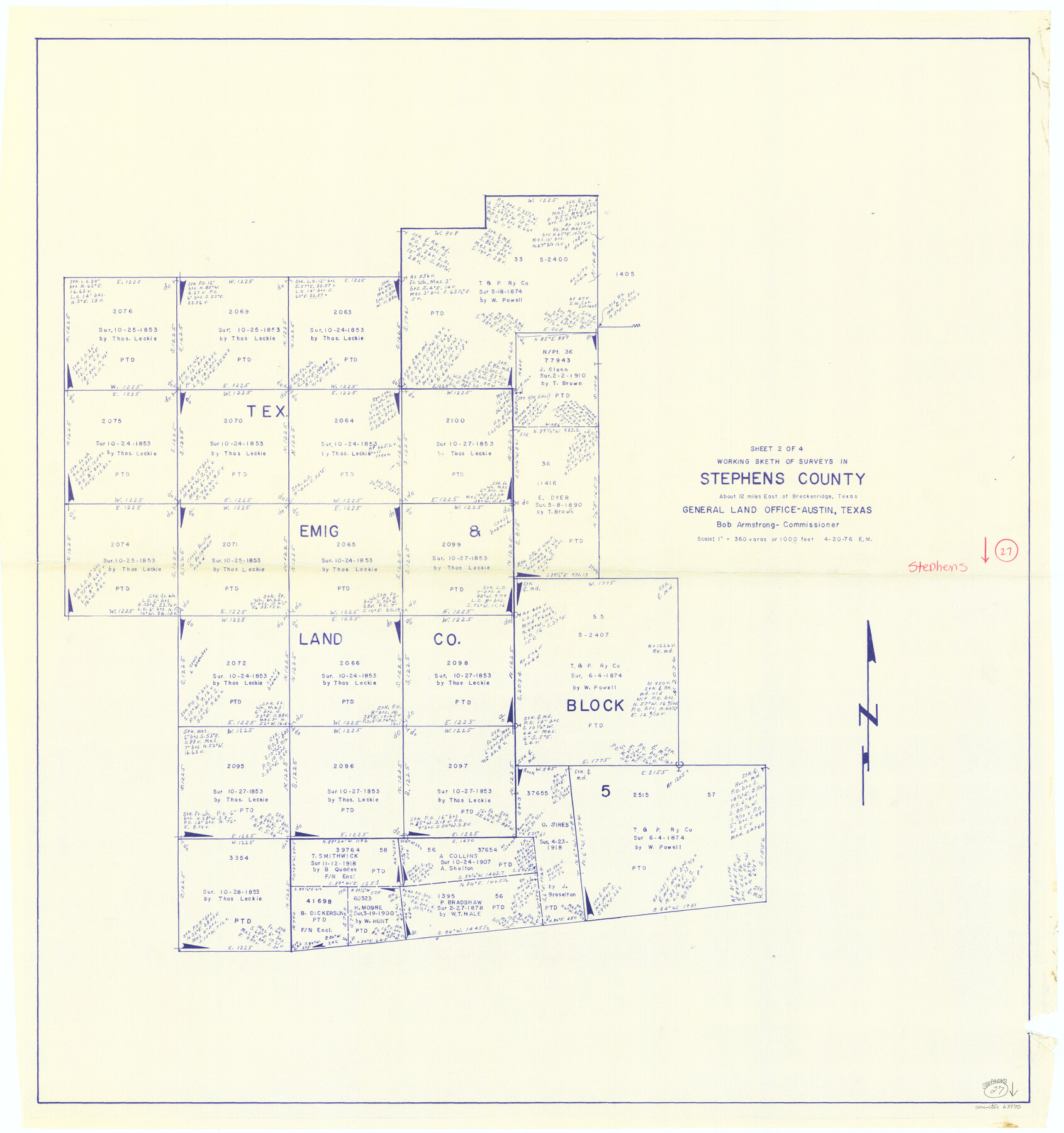
Stephens County Working Sketch 27
-
Map/Doc
63970
-
Collection
General Map Collection
-
Object Dates
4/20/1976 (Creation Date)
-
People and Organizations
Elbert Menzel (Draftsman)
-
Counties
Stephens
-
Subjects
Surveying Working Sketch
-
Height x Width
34.4 x 32.3 inches
87.4 x 82.0 cm
-
Scale
1" = 360 varas
Part of: General Map Collection
Tarrant County Sketch File 21

Print $4.00
- Digital $50.00
Tarrant County Sketch File 21
Size 12.5 x 8.4 inches
Map/Doc 37725
Map Showing Resurvey of Capitol Leagues, Lamb, Cochran & Hockley Co's.

Print $20.00
- Digital $50.00
Map Showing Resurvey of Capitol Leagues, Lamb, Cochran & Hockley Co's.
1918
Size 37.0 x 29.3 inches
Map/Doc 1759
Shackelford County Rolled Sketch 2

Print $40.00
- Digital $50.00
Shackelford County Rolled Sketch 2
Size 18.9 x 51.9 inches
Map/Doc 75935
Gaines County Rolled Sketch 29

Print $20.00
- Digital $50.00
Gaines County Rolled Sketch 29
1990
Size 14.7 x 20.5 inches
Map/Doc 5942
Terry County Sketch File 4

Print $20.00
- Digital $50.00
Terry County Sketch File 4
1913
Size 14.4 x 8.7 inches
Map/Doc 38016
[Subdivision of Nueces Bay and list of Court Decrees]
![2086, [Subdivision of Nueces Bay and list of Court Decrees], General Map Collection](https://historictexasmaps.com/wmedia_w700/maps/2086-1.tif.jpg)
Print $40.00
- Digital $50.00
[Subdivision of Nueces Bay and list of Court Decrees]
1940
Size 34.2 x 48.8 inches
Map/Doc 2086
Kaufman County Sketch File 7

Print $5.00
- Digital $50.00
Kaufman County Sketch File 7
1847
Size 8.3 x 10.1 inches
Map/Doc 28636

Upper Galveston Bay, Houston Ship Channel, Dollar Pt. to Atkinson I.

Print $40.00
- Digital $50.00
Upper Galveston Bay, Houston Ship Channel, Dollar Pt. to Atkinson I.
1992
Size 49.2 x 37.0 inches
Map/Doc 69899
Llano County Working Sketch 9

Print $20.00
- Digital $50.00
Llano County Working Sketch 9
1979
Size 33.4 x 24.0 inches
Map/Doc 70627
Brazos River, Koy Bridge Sheet/Mill Creek

Print $20.00
- Digital $50.00
Brazos River, Koy Bridge Sheet/Mill Creek
1933
Size 44.0 x 27.3 inches
Map/Doc 65290
Jackson County Sketch File 6

Print $4.00
- Digital $50.00
Jackson County Sketch File 6
1897
Size 13.1 x 8.9 inches
Map/Doc 27632
You may also like
Duval County Rolled Sketch 44

Print $40.00
- Digital $50.00
Duval County Rolled Sketch 44
1981
Size 36.5 x 90.5 inches
Map/Doc 8821
Erath County Working Sketch 19

Print $20.00
- Digital $50.00
Erath County Working Sketch 19
1963
Size 30.1 x 27.6 inches
Map/Doc 69100
Motley County Sketch File 2D (N)

Print $20.00
- Digital $50.00
Motley County Sketch File 2D (N)
Size 14.3 x 9.0 inches
Map/Doc 31984
General Land Office and State Reclamation Department - Topographic Sheets

Print $20.00
- Digital $50.00
General Land Office and State Reclamation Department - Topographic Sheets
1930
Size 26.2 x 16.7 inches
Map/Doc 65264
Harris County Working Sketch 81

Print $20.00
- Digital $50.00
Harris County Working Sketch 81
1969
Size 23.6 x 30.0 inches
Map/Doc 65973
[Tie line from Northeast Block 36, Township 5N to Northwest corner Block M]
![90559, [Tie line from Northeast Block 36, Township 5N to Northwest corner Block M], Twichell Survey Records](https://historictexasmaps.com/wmedia_w700/maps/90559-1.tif.jpg)
Print $20.00
- Digital $50.00
[Tie line from Northeast Block 36, Township 5N to Northwest corner Block M]
Size 22.3 x 10.3 inches
Map/Doc 90559
Harris County Sketch File 77

Print $26.00
- Digital $50.00
Harris County Sketch File 77
1953
Size 11.3 x 8.8 inches
Map/Doc 25546
Wharton County Sketch File 25

Print $4.00
- Digital $50.00
Wharton County Sketch File 25
1978
Size 11.1 x 8.7 inches
Map/Doc 39988
Edwards County

Print $20.00
- Digital $50.00
Edwards County
1893
Size 30.8 x 33.1 inches
Map/Doc 3507
Hamilton County Rolled Sketch 12

Print $20.00
- Digital $50.00
Hamilton County Rolled Sketch 12
1981
Size 35.2 x 28.7 inches
Map/Doc 6061
Grimes County Working Sketch 7

Print $20.00
- Digital $50.00
Grimes County Working Sketch 7
1963
Size 27.2 x 33.0 inches
Map/Doc 63298
Wichita County Working Sketch 10

Print $20.00
- Digital $50.00
Wichita County Working Sketch 10
1920
Size 25.4 x 16.1 inches
Map/Doc 72519