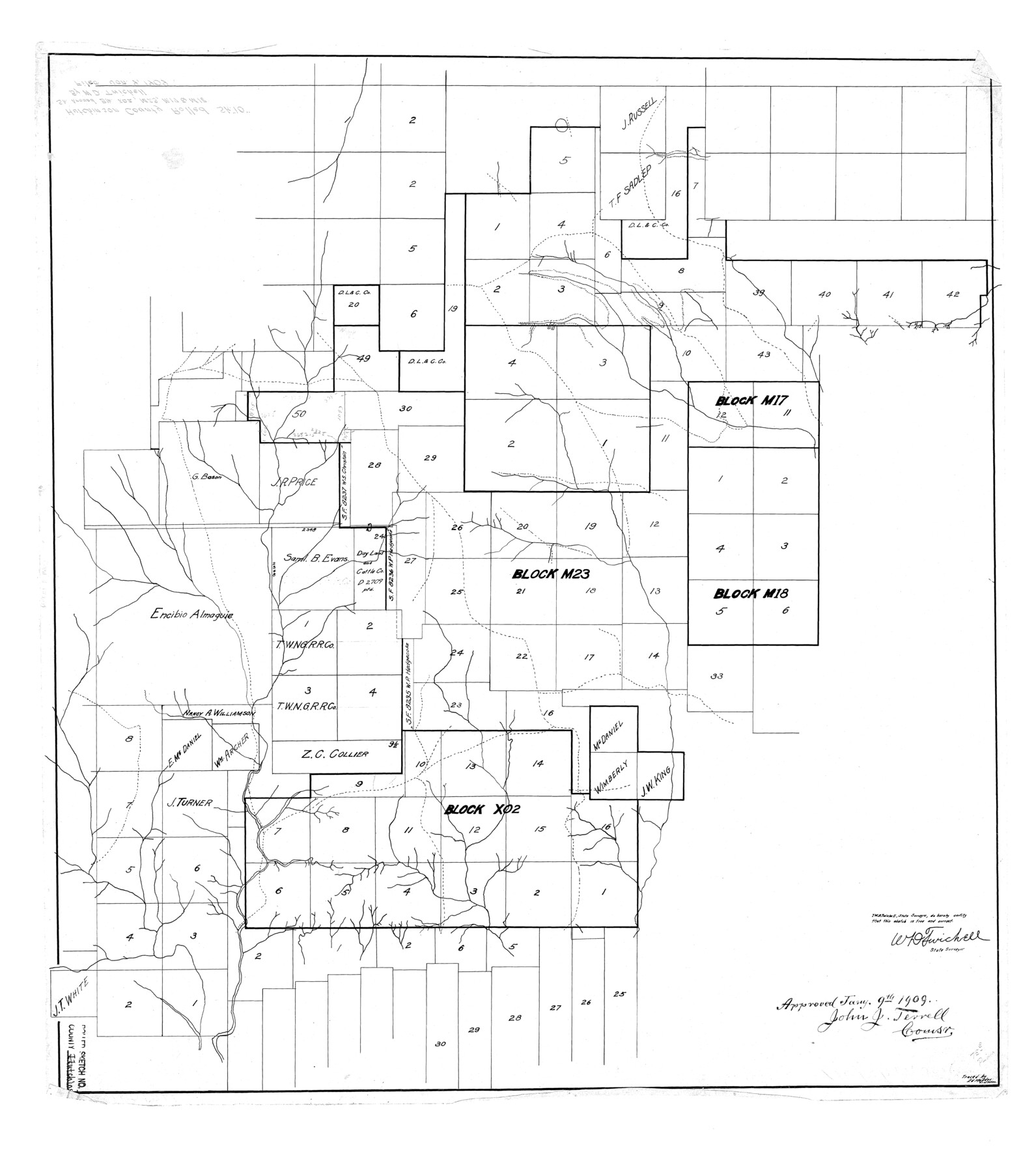
Hutchinson County Rolled Sketch 10
[Sketch of area around Blks. X02, M23, M17 & M18, Hutchinson County, Texas]
-
Map/Doc
6281
-
Collection
General Map Collection
-
Object Dates
1909/1/9 (File Date)
-
People and Organizations
W.D. Twichell (Surveyor/Engineer)
-
Counties
Hutchinson
-
Subjects
Surveying Rolled Sketch
-
Height x Width
33.6 x 29.7 inches
85.3 x 75.4 cm
Part of: General Map Collection
Duval County Sketch File 39

Print $20.00
- Digital $50.00
Duval County Sketch File 39
Size 32.1 x 23.9 inches
Map/Doc 11395
Uvalde County Rolled Sketch 22

Print $20.00
- Digital $50.00
Uvalde County Rolled Sketch 22
2002
Size 30.4 x 41.0 inches
Map/Doc 78656
Crosby County Sketch File 14a

Print $40.00
- Digital $50.00
Crosby County Sketch File 14a
Size 18.9 x 20.5 inches
Map/Doc 11249
Trinity County Sketch File 24

Print $4.00
- Digital $50.00
Trinity County Sketch File 24
Size 7.5 x 10.5 inches
Map/Doc 38556
Harris County Historic Topographic A

Print $20.00
- Digital $50.00
Harris County Historic Topographic A
1916
Size 26.1 x 19.0 inches
Map/Doc 65849
The Military History of Texas Map!

The Military History of Texas Map!
1996
Size 24.2 x 35.0 inches
Map/Doc 96828
Travis County Sketch File 63

Print $14.00
- Digital $50.00
Travis County Sketch File 63
Size 13.5 x 9.2 inches
Map/Doc 38431
Cass County Working Sketch 37

Print $20.00
- Digital $50.00
Cass County Working Sketch 37
1982
Size 26.8 x 31.8 inches
Map/Doc 67940
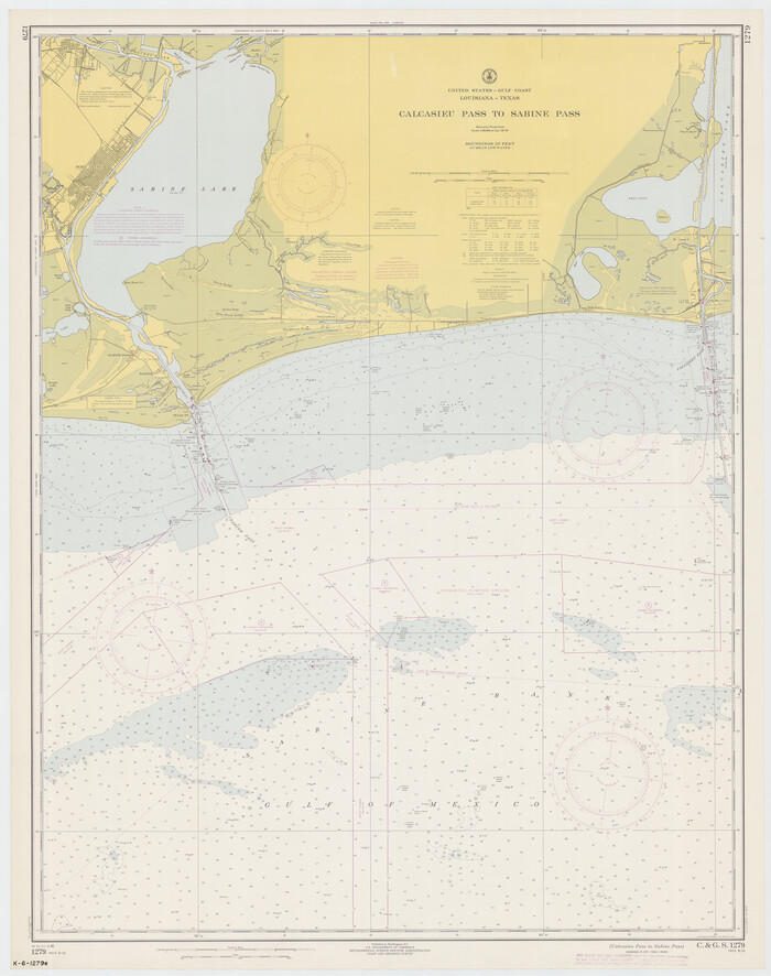
Calcasieu Pass to Sabine Pass
Print $20.00
- Digital $50.00
Calcasieu Pass to Sabine Pass
1966
Size 44.9 x 35.5 inches
Map/Doc 69810
Duval County Sketch File 23

Print $4.00
- Digital $50.00
Duval County Sketch File 23
Size 8.1 x 7.1 inches
Map/Doc 21326
Pecos County Rolled Sketch 39

Print $20.00
- Digital $50.00
Pecos County Rolled Sketch 39
1908
Size 21.8 x 33.2 inches
Map/Doc 7217
University Land in Hudspeth County showing Mineral Surveys in Blocks A, B, C, D, E, F, G, H, I, J, K, L, M, N

Print $40.00
- Digital $50.00
University Land in Hudspeth County showing Mineral Surveys in Blocks A, B, C, D, E, F, G, H, I, J, K, L, M, N
Size 39.7 x 48.4 inches
Map/Doc 2421
You may also like
General Highway Map, Carson County, Texas

Print $20.00
General Highway Map, Carson County, Texas
1940
Size 18.5 x 25.1 inches
Map/Doc 79041
Limestone County Sketch File 28

Print $54.00
- Digital $50.00
Limestone County Sketch File 28
1986
Size 11.2 x 8.5 inches
Map/Doc 30216
Brazoria County Rolled Sketch 20

Print $20.00
- Digital $50.00
Brazoria County Rolled Sketch 20
1917
Size 31.1 x 47.1 inches
Map/Doc 8929
Burnet County Boundary File 4

Print $30.00
- Digital $50.00
Burnet County Boundary File 4
Size 8.8 x 8.1 inches
Map/Doc 50872
[Surveys along the San Jacinto River]
![62, [Surveys along the San Jacinto River], General Map Collection](https://historictexasmaps.com/wmedia_w700/maps/62.tif.jpg)
Print $3.00
- Digital $50.00
[Surveys along the San Jacinto River]
1841
Size 10.7 x 14.5 inches
Map/Doc 62
Crockett County Working Sketch 89

Print $20.00
- Digital $50.00
Crockett County Working Sketch 89
1978
Size 36.4 x 44.5 inches
Map/Doc 68422
Map of Winkler County

Print $20.00
- Digital $50.00
Map of Winkler County
1901
Size 43.1 x 36.6 inches
Map/Doc 4158
Flight Mission No. CGI-3N, Frame 73, Cameron County

Print $20.00
- Digital $50.00
Flight Mission No. CGI-3N, Frame 73, Cameron County
1954
Size 18.4 x 22.4 inches
Map/Doc 84567
Shelby County Sketch File 33

Print $8.00
- Digital $50.00
Shelby County Sketch File 33
1949
Size 11.5 x 9.0 inches
Map/Doc 36670
Medina County Working Sketch 17

Print $20.00
- Digital $50.00
Medina County Working Sketch 17
1979
Size 26.8 x 34.5 inches
Map/Doc 70932
[Atchison, Topeka & Santa Fe from Paisano to south of Plata]
![64709, [Atchison, Topeka & Santa Fe from Paisano to south of Plata], General Map Collection](https://historictexasmaps.com/wmedia_w700/maps/64709.tif.jpg)
Print $40.00
- Digital $50.00
[Atchison, Topeka & Santa Fe from Paisano to south of Plata]
Size 32.3 x 120.8 inches
Map/Doc 64709
Travis County Sketch File 47

Print $6.00
- Digital $50.00
Travis County Sketch File 47
1939
Size 14.3 x 8.9 inches
Map/Doc 38374