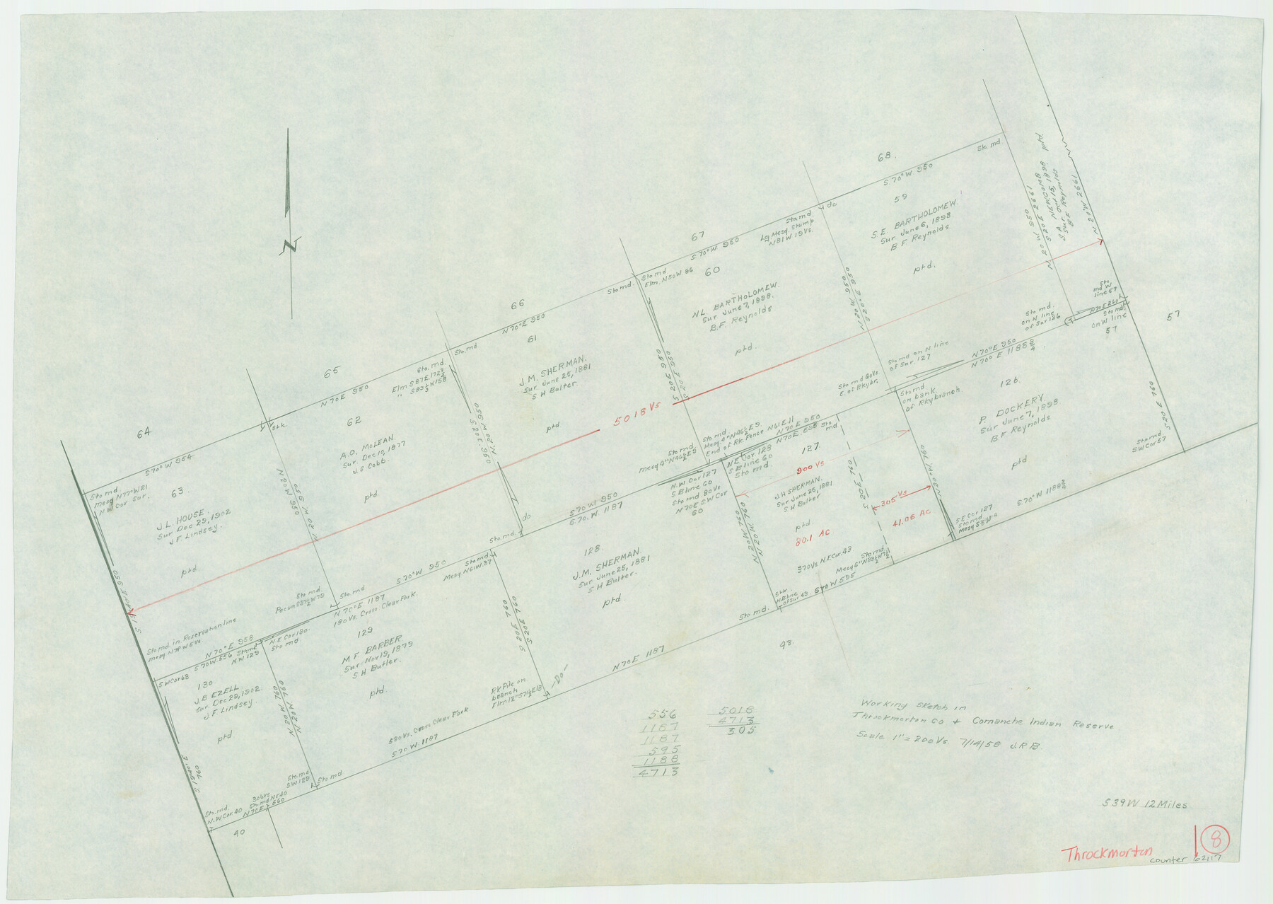
Throckmorton County Working Sketch 8
-
Map/Doc
62117
-
Collection
General Map Collection
-
Object Dates
7/14/1958 (Creation Date)
-
Counties
Throckmorton
-
Subjects
Surveying Working Sketch
-
Height x Width
21.6 x 30.4 inches
54.9 x 77.2 cm
-
Scale
1" = 200 varas
Part of: General Map Collection
Brazos River, Clemens State Farm Sheet

Print $20.00
- Digital $50.00
Brazos River, Clemens State Farm Sheet
1915
Size 37.5 x 34.6 inches
Map/Doc 69673
Nueces County Aerial Photograph Index Sheet 21

Print $20.00
- Digital $50.00
Nueces County Aerial Photograph Index Sheet 21
1938
Size 24.3 x 20.2 inches
Map/Doc 86842
Duval County Working Sketch 29

Print $20.00
- Digital $50.00
Duval County Working Sketch 29
1948
Size 28.9 x 31.5 inches
Map/Doc 68753
Robertson County Working Sketch 21

Print $20.00
- Digital $50.00
Robertson County Working Sketch 21
2006
Size 44.0 x 33.1 inches
Map/Doc 84701
Nueces County Rolled Sketch 103

Print $105.00
Nueces County Rolled Sketch 103
1985
Size 36.5 x 24.1 inches
Map/Doc 7078
Chambers County Aerial Photograph Index Sheet 3

Print $20.00
- Digital $50.00
Chambers County Aerial Photograph Index Sheet 3
1956
Size 20.5 x 15.7 inches
Map/Doc 83684
Burleson County

Print $20.00
- Digital $50.00
Burleson County
1920
Size 38.0 x 45.0 inches
Map/Doc 4790
Houston & Great Northern RR through Smith & other counties

Print $66.00
- Digital $50.00
Houston & Great Northern RR through Smith & other counties
1872
Size 14.2 x 8.4 inches
Map/Doc 64339
Galveston County

Print $40.00
- Digital $50.00
Galveston County
1939
Size 42.9 x 54.9 inches
Map/Doc 77287
El Paso County Sketch File 37

Print $4.00
- Digital $50.00
El Paso County Sketch File 37
1987
Size 14.4 x 9.1 inches
Map/Doc 22221
Eastland County Working Sketch 27

Print $20.00
- Digital $50.00
Eastland County Working Sketch 27
1952
Size 25.2 x 21.4 inches
Map/Doc 68808
Wilson County Sketch File 5

Print $4.00
- Digital $50.00
Wilson County Sketch File 5
1859
Size 6.6 x 8.2 inches
Map/Doc 40408
You may also like
Bee County Working Sketch 30

Print $20.00
- Digital $50.00
Bee County Working Sketch 30
1950
Size 12.7 x 15.7 inches
Map/Doc 67281
A Map of the Indian Territory, Northern Texas and New Mexico showing the [G]reat Western Prairies
![97127, A Map of the Indian Territory, Northern Texas and New Mexico showing the [G]reat Western Prairies, General Map Collection](https://historictexasmaps.com/wmedia_w700/97127.tif.jpg)
Print $20.00
- Digital $50.00
A Map of the Indian Territory, Northern Texas and New Mexico showing the [G]reat Western Prairies
1844
Size 15.0 x 16.0 inches
Map/Doc 97127
[Littlefield Subdivision Blocks 657-687]
![91009, [Littlefield Subdivision Blocks 657-687], Twichell Survey Records](https://historictexasmaps.com/wmedia_w700/maps/91009-1.tif.jpg)
Print $20.00
- Digital $50.00
[Littlefield Subdivision Blocks 657-687]
Size 31.2 x 20.5 inches
Map/Doc 91009
Pecos County Rolled Sketch 32

Print $20.00
- Digital $50.00
Pecos County Rolled Sketch 32
1890
Size 21.0 x 14.1 inches
Map/Doc 7214
Americae Sive Novi Orbis Nova Descriptio

Print $20.00
- Digital $50.00
Americae Sive Novi Orbis Nova Descriptio
1606
Size 16.5 x 22.4 inches
Map/Doc 93810
Coke County Rolled Sketch 16A

Print $20.00
- Digital $50.00
Coke County Rolled Sketch 16A
Size 32.3 x 30.4 inches
Map/Doc 5518
Map Showing Lands Surveyed by Sylvan Sanders, Block D

Print $20.00
- Digital $50.00
Map Showing Lands Surveyed by Sylvan Sanders, Block D
Size 28.9 x 24.2 inches
Map/Doc 92441
Red River County Working Sketch 33

Print $20.00
- Digital $50.00
Red River County Working Sketch 33
1963
Size 47.0 x 22.2 inches
Map/Doc 72016
Flight Mission No. DIX-8P, Frame 83, Aransas County

Print $20.00
- Digital $50.00
Flight Mission No. DIX-8P, Frame 83, Aransas County
1956
Size 18.6 x 22.3 inches
Map/Doc 83908
Pecos County Sketch File 28a

Print $14.00
- Digital $50.00
Pecos County Sketch File 28a
1911
Size 14.5 x 8.9 inches
Map/Doc 33683
Donley County Rolled Sketch 2

Print $20.00
- Digital $50.00
Donley County Rolled Sketch 2
Size 41.8 x 34.3 inches
Map/Doc 8800
United States Population Distribution by County and Territory, per the U.S. Census of 1890

United States Population Distribution by County and Territory, per the U.S. Census of 1890
2025
Size 8.5 x 11.0 inches
Map/Doc 97480