Harris County State Real Property Sketch 1
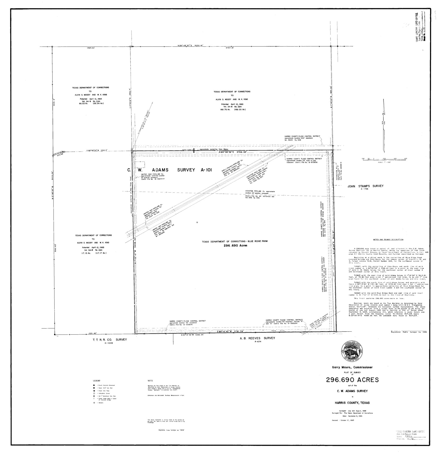
A Plat of a Survey of 296.690 Acres Out of the C. W. Adams Survey, A - 101, for the Texas Department of Corrections, Blue Ridge Farm
State Real Property Sketch S - 16
-
Map/Doc
61690
-
Collection
General Map Collection
-
Object Dates
1985/10/17 (Creation Date)
-
People and Organizations
Texas General Land Office (Publisher)
Texas General Land Office (Printer)
Garry Mauro (GLO Commissioner)
Elisandro Leos (Surveyor/Engineer)
-
Counties
Harris
-
Subjects
State Real Property
-
Height x Width
42.7 x 41.6 inches
108.5 x 105.7 cm
-
Comments
Surveyed in July and August 1985.
Surveys located about 12 miles South 38 degrees West of Houston, Texas.
Part of: General Map Collection
Stephens County Sketch File 26

Print $10.00
- Digital $50.00
Stephens County Sketch File 26
Size 14.1 x 8.8 inches
Map/Doc 37096
Live Oak County Working Sketch 24

Print $20.00
- Digital $50.00
Live Oak County Working Sketch 24
1978
Size 31.9 x 38.2 inches
Map/Doc 70609
Uvalde County Boundary File 1a

Print $12.00
- Digital $50.00
Uvalde County Boundary File 1a
Size 14.5 x 8.9 inches
Map/Doc 59551

Liberty County Rolled Sketch M

Print $40.00
- Digital $50.00
Liberty County Rolled Sketch M
1953
Size 23.6 x 56.6 inches
Map/Doc 10651
Shelby County Rolled Sketch 15

Print $40.00
- Digital $50.00
Shelby County Rolled Sketch 15
1948
Size 22.8 x 54.4 inches
Map/Doc 10313
Hardin County Working Sketch 29

Print $20.00
- Digital $50.00
Hardin County Working Sketch 29
1958
Size 36.7 x 22.1 inches
Map/Doc 63427
![94159, Austin Street Map [Verso], General Map Collection](https://historictexasmaps.com/wmedia_w700/maps/94159.tif.jpg)
Kinney County Working Sketch 20

Print $20.00
- Digital $50.00
Kinney County Working Sketch 20
1948
Size 31.3 x 24.3 inches
Map/Doc 70202
Midland County Working Sketch 25

Print $40.00
- Digital $50.00
Midland County Working Sketch 25
1957
Size 58.3 x 49.1 inches
Map/Doc 71006
Live Oak County Working Sketch 3

Print $20.00
- Digital $50.00
Live Oak County Working Sketch 3
1910
Size 21.5 x 19.0 inches
Map/Doc 70588
Concho County Sketch File 38

Print $4.00
- Digital $50.00
Concho County Sketch File 38
1938
Size 14.6 x 9.0 inches
Map/Doc 19188
You may also like
Shackelford County Boundary File 7a

Print $9.00
- Digital $50.00
Shackelford County Boundary File 7a
Size 14.9 x 9.4 inches
Map/Doc 58689
Lamb County Rolled Sketch 7
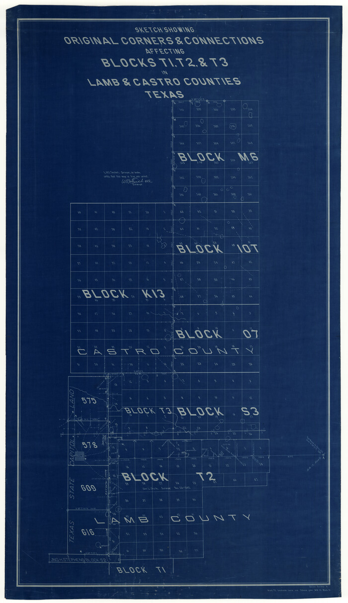
Print $20.00
- Digital $50.00
Lamb County Rolled Sketch 7
Size 45.6 x 26.3 inches
Map/Doc 9415
El Paso County

Print $40.00
- Digital $50.00
El Paso County
1881
Size 52.6 x 42.4 inches
Map/Doc 89058
Williamson County Working Sketch 16

Print $20.00
- Digital $50.00
Williamson County Working Sketch 16
1984
Size 31.9 x 23.7 inches
Map/Doc 72576
Culberson County Rolled Sketch 56

Print $37.00
- Digital $50.00
Culberson County Rolled Sketch 56
1972
Size 11.0 x 15.6 inches
Map/Doc 44267
Controlled Mosaic by Jack Amman Photogrammetric Engineers, Inc - Sheet 26

Print $20.00
- Digital $50.00
Controlled Mosaic by Jack Amman Photogrammetric Engineers, Inc - Sheet 26
1954
Size 20.0 x 24.0 inches
Map/Doc 83477
Pecos County Rolled Sketch 181

Print $20.00
- Digital $50.00
Pecos County Rolled Sketch 181
1980
Size 18.4 x 18.7 inches
Map/Doc 7300
The Peters Colony. July 26, 1842

Print $20.00
The Peters Colony. July 26, 1842
2020
Size 21.7 x 21.7 inches
Map/Doc 96364
United States Atlantic and Gulf Coasts Including Puerto Rico and the Virgin Islands

Print $40.00
- Digital $50.00
United States Atlantic and Gulf Coasts Including Puerto Rico and the Virgin Islands
1992
Size 21.6 x 60.4 inches
Map/Doc 76124
Coryell County Working Sketch 3

Print $20.00
- Digital $50.00
Coryell County Working Sketch 3
1928
Size 23.6 x 22.5 inches
Map/Doc 68210
Hidalgo County Sketch File 15

Print $12.00
- Digital $50.00
Hidalgo County Sketch File 15
1878
Size 10.1 x 7.9 inches
Map/Doc 26431
Tom Green County Sketch File 58

Print $6.00
- Digital $50.00
Tom Green County Sketch File 58
Size 15.9 x 9.4 inches
Map/Doc 38225