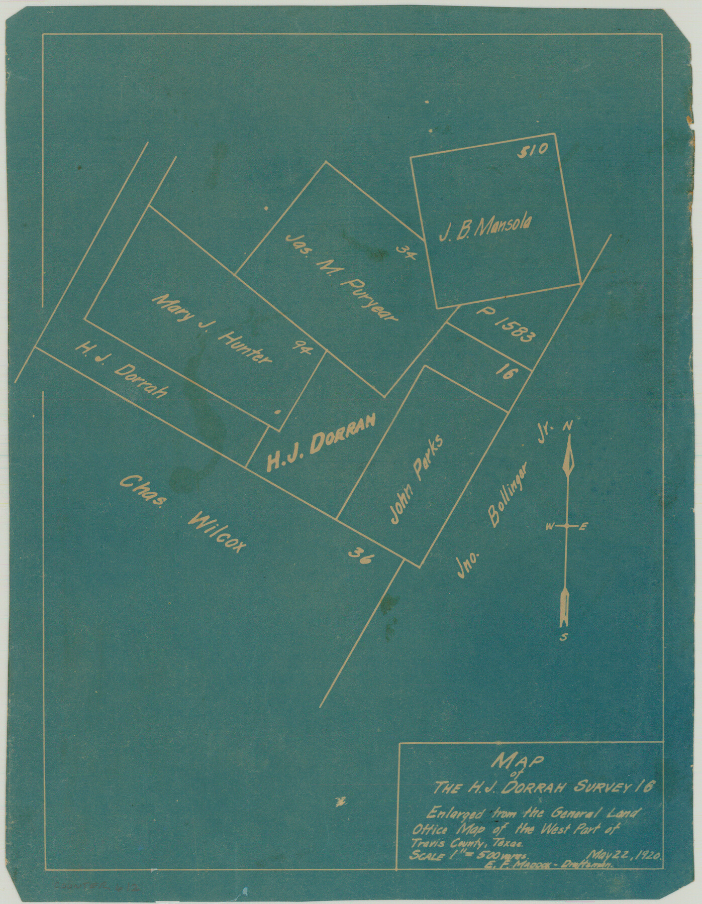
Map of the H.J. Dorrah survey 16 enlarged from the General Land Office map of the west part of Travis County, Texas
-
Map/Doc
612
-
Collection
Maddox Collection
-
Object Dates
1920/5/22 (Creation Date)
-
People and Organizations
E.F. Maddox (Draftsman)
GLO (Author)
-
Counties
Travis Hays
-
Height x Width
11.1 x 8.6 inches
28.2 x 21.8 cm
-
Medium
blueprint/diazo
-
Scale
1" = 500 varas
-
Comments
Enlarged from the General Land Office Map of the West Part of Travis County, Texas
Part of: Maddox Collection
Dimmit County, Texas

Print $20.00
- Digital $50.00
Dimmit County, Texas
1879
Size 22.6 x 28.6 inches
Map/Doc 5031
Floyd County, Texas

Print $20.00
- Digital $50.00
Floyd County, Texas
1889
Size 24.8 x 19.2 inches
Map/Doc 626
Sketch from the map of Bailey Co.

Print $2.00
- Digital $50.00
Sketch from the map of Bailey Co.
Size 8.4 x 7.6 inches
Map/Doc 464
Midland County, Texas

Print $20.00
- Digital $50.00
Midland County, Texas
1880
Size 25.5 x 21.5 inches
Map/Doc 740
Map of surveys 191 & 192 T. C. R.R. Co. in Travis County, Texas

Print $20.00
- Digital $50.00
Map of surveys 191 & 192 T. C. R.R. Co. in Travis County, Texas
1915
Size 20.6 x 13.5 inches
Map/Doc 75556
Smith County, Texas

Print $20.00
- Digital $50.00
Smith County, Texas
1880
Size 23.7 x 29.2 inches
Map/Doc 618
Survey 1, Block 1, D.B. Gardner in Dickens County

Print $20.00
- Digital $50.00
Survey 1, Block 1, D.B. Gardner in Dickens County
1914
Size 14.9 x 30.4 inches
Map/Doc 10767
Map of Martinsburg Property, Gillespie Co., Tex.

Print $20.00
- Digital $50.00
Map of Martinsburg Property, Gillespie Co., Tex.
Size 15.7 x 13.6 inches
Map/Doc 446
[Town Plat of Lamar]
![4462, [Town Plat of Lamar], Maddox Collection](https://historictexasmaps.com/wmedia_w700/maps/4462-1.tif.jpg)
Print $20.00
- Digital $50.00
[Town Plat of Lamar]
Size 19.0 x 25.0 inches
Map/Doc 4462
Sketch in Hays County

Print $2.00
- Digital $50.00
Sketch in Hays County
1889
Size 8.4 x 8.3 inches
Map/Doc 5038
[Juan Jose Balli Survey, Kenedy County, Texas]
![[Juan Jose Balli Survey, Kenedy County, Texas]](https://historictexasmaps.com/wmedia_w700/maps/4444 - new.tif.jpg)
Print $3.00
- Digital $50.00
[Juan Jose Balli Survey, Kenedy County, Texas]
Size 9.8 x 13.4 inches
Map/Doc 4444
Working Sketch in Cottle, Foard & Hardeman Counties

Print $20.00
- Digital $50.00
Working Sketch in Cottle, Foard & Hardeman Counties
1917
Size 26.9 x 28.0 inches
Map/Doc 4485
You may also like
The Republic County of Travis. December 29, 1845

Print $20.00
The Republic County of Travis. December 29, 1845
2020
Size 20.8 x 21.6 inches
Map/Doc 96293
The Republic County of Harrison. Created, January 28, 1839

Print $20.00
The Republic County of Harrison. Created, January 28, 1839
2020
Size 18.6 x 21.7 inches
Map/Doc 96169
Harris County Boundary File 40

Print $8.00
- Digital $50.00
Harris County Boundary File 40
Size 14.2 x 8.7 inches
Map/Doc 54370
Bastrop County Rolled Sketch 5

Print $20.00
- Digital $50.00
Bastrop County Rolled Sketch 5
2013
Size 24.9 x 36.9 inches
Map/Doc 93715
[T. & N. O. RR. Co and H. & T. C. RR. Co. Blocks]
![90430, [T. & N. O. RR. Co and H. & T. C. RR. Co. Blocks], Twichell Survey Records](https://historictexasmaps.com/wmedia_w700/maps/90430-1.tif.jpg)
Print $2.00
- Digital $50.00
[T. & N. O. RR. Co and H. & T. C. RR. Co. Blocks]
1924
Size 8.3 x 8.2 inches
Map/Doc 90430
Nueces County Rolled Sketch 108

Print $62.00
Nueces County Rolled Sketch 108
1987
Size 18.6 x 23.5 inches
Map/Doc 7112
The Republic County of Galveston. December 16, 1839

Print $20.00
The Republic County of Galveston. December 16, 1839
2020
Size 14.7 x 21.9 inches
Map/Doc 96144
Brewster County Rolled Sketch 115

Print $40.00
- Digital $50.00
Brewster County Rolled Sketch 115
1958
Size 11.5 x 138.4 inches
Map/Doc 8514
Loving County Sketch File 6

Print $10.00
- Digital $50.00
Loving County Sketch File 6
1963
Size 7.2 x 5.9 inches
Map/Doc 41451
Map of the Western Territory &c.

Print $20.00
- Digital $50.00
Map of the Western Territory &c.
1834
Size 18.5 x 18.8 inches
Map/Doc 95691
Flight Mission No. DAG-28K, Frame 32, Matagorda County

Print $20.00
- Digital $50.00
Flight Mission No. DAG-28K, Frame 32, Matagorda County
1953
Size 16.2 x 16.0 inches
Map/Doc 86600
Block M6 in Castro, Swisher, and Randall Co's, Tex.

Print $20.00
- Digital $50.00
Block M6 in Castro, Swisher, and Randall Co's, Tex.
Size 13.8 x 17.2 inches
Map/Doc 90397