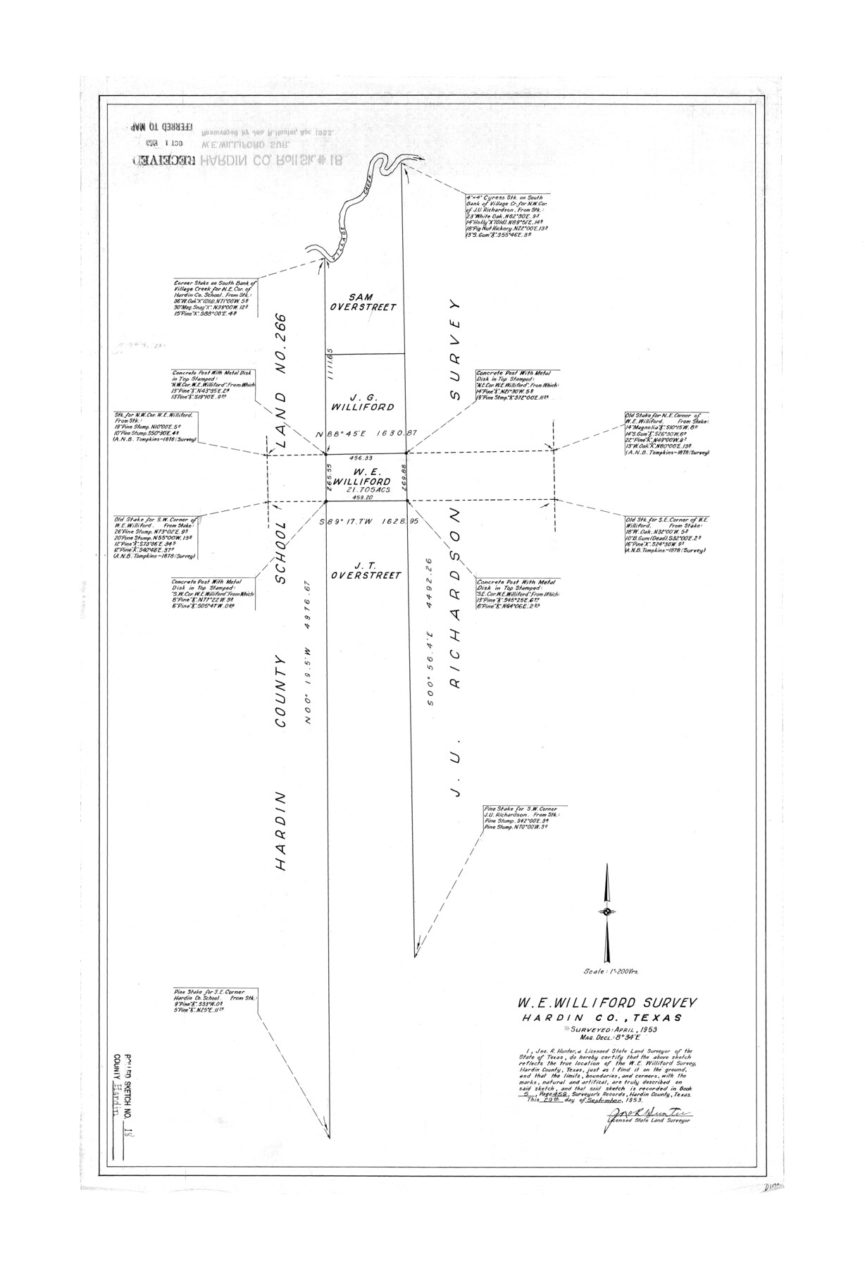
Hardin County Rolled Sketch 18
W.E. Williford survey, Hardin Co., Texas
-
Map/Doc
6088
-
Collection
General Map Collection
-
Object Dates
1953/9/29 (Creation Date)
1953 (Survey Date)
-
People and Organizations
Jno. R. Hunter (Surveyor/Engineer)
-
Counties
Hardin
-
Subjects
Surveying Rolled Sketch
-
Height x Width
35.8 x 24.4 inches
90.9 x 62.0 cm
-
Scale
1" = 200 varas
Part of: General Map Collection
Bailey County

Print $20.00
- Digital $50.00
Bailey County
1956
Size 47.0 x 30.0 inches
Map/Doc 77206
Travis County Working Sketch 54

Print $20.00
- Digital $50.00
Travis County Working Sketch 54
1976
Size 30.1 x 32.0 inches
Map/Doc 69438
Rio Grande, Donna Sheet

Print $20.00
- Digital $50.00
Rio Grande, Donna Sheet
1937
Size 37.5 x 37.4 inches
Map/Doc 65117
Cherokee County Working Sketch 10

Print $40.00
- Digital $50.00
Cherokee County Working Sketch 10
1957
Size 58.1 x 43.2 inches
Map/Doc 67965
Crockett County Rolled Sketch 46A

Print $40.00
- Digital $50.00
Crockett County Rolled Sketch 46A
Size 43.4 x 63.9 inches
Map/Doc 9199
Flight Mission No. CRK-3P, Frame 66, Refugio County

Print $20.00
- Digital $50.00
Flight Mission No. CRK-3P, Frame 66, Refugio County
1956
Size 18.6 x 22.4 inches
Map/Doc 86908
Maps & Lists Showing Prison Lands (Oil & Gas) Leased as of June 1955

Digital $50.00
Maps & Lists Showing Prison Lands (Oil & Gas) Leased as of June 1955
1934
Size 35.6 x 32.3 inches
Map/Doc 62879
Galveston County Sketch File 54

Print $14.00
- Digital $50.00
Galveston County Sketch File 54
1838
Size 12.8 x 8.2 inches
Map/Doc 23584
Kent County Sketch File 6

Print $4.00
- Digital $50.00
Kent County Sketch File 6
1910
Size 8.3 x 7.0 inches
Map/Doc 28830
Reagan County Working Sketch 31

Print $20.00
- Digital $50.00
Reagan County Working Sketch 31
1964
Size 38.7 x 36.6 inches
Map/Doc 71873
Brewster County Rolled Sketch 85

Print $20.00
- Digital $50.00
Brewster County Rolled Sketch 85
1946
Size 30.4 x 22.8 inches
Map/Doc 5246
Maps of Gulf Intracoastal Waterway, Texas - Sabine River to the Rio Grande and connecting waterways including ship channels

Print $20.00
- Digital $50.00
Maps of Gulf Intracoastal Waterway, Texas - Sabine River to the Rio Grande and connecting waterways including ship channels
1966
Size 14.6 x 22.3 inches
Map/Doc 61938
You may also like
Cameron County Aerial Photograph Index Sheet 5

Print $20.00
- Digital $50.00
Cameron County Aerial Photograph Index Sheet 5
1940
Size 20.4 x 24.3 inches
Map/Doc 83681
Potter County Sketch File 22

Print $30.00
- Digital $50.00
Potter County Sketch File 22
1962
Size 14.2 x 8.6 inches
Map/Doc 34415
Winkler County Sketch File 18

Print $8.00
- Digital $50.00
Winkler County Sketch File 18
1999
Size 11.2 x 8.7 inches
Map/Doc 40517
Map of Lavaca County

Print $20.00
- Digital $50.00
Map of Lavaca County
1866
Size 22.3 x 23.7 inches
Map/Doc 3802
Kendall County Working Sketch 5

Print $20.00
- Digital $50.00
Kendall County Working Sketch 5
1946
Size 30.4 x 28.6 inches
Map/Doc 66677
Stephens County Working Sketch 33

Print $20.00
- Digital $50.00
Stephens County Working Sketch 33
1978
Size 31.1 x 30.8 inches
Map/Doc 63976
Harrison County Working Sketch 23

Print $20.00
- Digital $50.00
Harrison County Working Sketch 23
1983
Size 43.2 x 32.2 inches
Map/Doc 66043
Hardin County Sketch File 47

Print $4.00
- Digital $50.00
Hardin County Sketch File 47
1875
Size 7.2 x 7.2 inches
Map/Doc 25200
Maverick County Rolled Sketch 14A

Print $20.00
- Digital $50.00
Maverick County Rolled Sketch 14A
Size 35.4 x 18.2 inches
Map/Doc 6708
Presidio County Sketch File 109

Print $6.00
- Digital $50.00
Presidio County Sketch File 109
Size 9.0 x 6.1 inches
Map/Doc 34815
Tom Green County Rolled Sketch 3

Print $20.00
- Digital $50.00
Tom Green County Rolled Sketch 3
Size 26.8 x 32.8 inches
Map/Doc 7993
Hudspeth County Sketch File 34

Print $12.00
- Digital $50.00
Hudspeth County Sketch File 34
1944
Size 11.2 x 8.8 inches
Map/Doc 26997