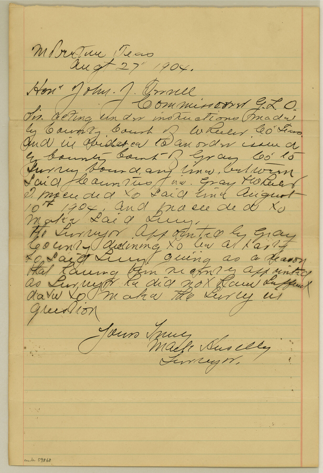
Wheeler County Boundary File 1a
[Letter regarding Wheeler-Gray Boundary Line]
-
Map/Doc
59868
-
Collection
General Map Collection
-
Counties
Wheeler
-
Subjects
County Boundaries
-
Height x Width
12.8 x 8.8 inches
32.5 x 22.4 cm
Part of: General Map Collection
Old Miscellaneous File 2

Print $16.00
- Digital $50.00
Old Miscellaneous File 2
1838
Size 13.0 x 8.0 inches
Map/Doc 75406
Carson County Sketch File 3

Print $32.00
- Digital $50.00
Carson County Sketch File 3
1888
Size 5.4 x 8.4 inches
Map/Doc 17335
Edwards County Sketch File 45

Print $26.00
- Digital $50.00
Edwards County Sketch File 45
1890
Size 13.3 x 8.4 inches
Map/Doc 21779
Ward County Rolled Sketch 7

Print $40.00
- Digital $50.00
Ward County Rolled Sketch 7
1907
Size 33.9 x 91.0 inches
Map/Doc 10103
Map of section no. 10 of a survey of Padre Island made for the Office of the Attorney General of the State of Texas

Print $40.00
- Digital $50.00
Map of section no. 10 of a survey of Padre Island made for the Office of the Attorney General of the State of Texas
1941
Size 57.2 x 40.6 inches
Map/Doc 2266
Chambers County Rolled Sketch 24A

Print $40.00
- Digital $50.00
Chambers County Rolled Sketch 24A
1940
Size 36.5 x 49.0 inches
Map/Doc 8595
Military Reconnaissance of the Arkansas Rio Del Norte and Rio Gila

Print $40.00
- Digital $50.00
Military Reconnaissance of the Arkansas Rio Del Norte and Rio Gila
1847
Size 33.0 x 72.2 inches
Map/Doc 552
Dallas County Boundary File 8 and 8a

Print $16.00
- Digital $50.00
Dallas County Boundary File 8 and 8a
Size 11.3 x 8.6 inches
Map/Doc 52304
Presidio County Rolled Sketch 128

Print $20.00
- Digital $50.00
Presidio County Rolled Sketch 128
1931
Size 26.9 x 38.0 inches
Map/Doc 7398
[Metropolitan Areas of Texas]
![96824, [Metropolitan Areas of Texas], General Map Collection](https://historictexasmaps.com/wmedia_w700/maps/96824.tif.jpg)
[Metropolitan Areas of Texas]
1994
Size 33.6 x 36.1 inches
Map/Doc 96824
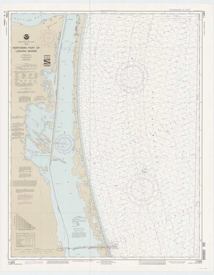
Northern Part of Laguna Madre
Print $20.00
- Digital $50.00
Northern Part of Laguna Madre
1992
Size 45.4 x 35.3 inches
Map/Doc 73532
Map of east portion of Matagorda Bay in Matagorda County showing subdivision for mineral development

Print $40.00
- Digital $50.00
Map of east portion of Matagorda Bay in Matagorda County showing subdivision for mineral development
Size 33.0 x 52.8 inches
Map/Doc 65809
You may also like
Map of Nacogdoches County

Print $40.00
- Digital $50.00
Map of Nacogdoches County
1839
Size 83.3 x 79.2 inches
Map/Doc 16775
Real County Working Sketch 79

Print $20.00
- Digital $50.00
Real County Working Sketch 79
1981
Size 19.8 x 22.2 inches
Map/Doc 71971
Crosby County Rolled Sketch 1A

Print $20.00
- Digital $50.00
Crosby County Rolled Sketch 1A
1950
Size 26.1 x 22.2 inches
Map/Doc 5641
United States - Gulf Coast Texas - Southern part of Laguna Madre

Print $20.00
- Digital $50.00
United States - Gulf Coast Texas - Southern part of Laguna Madre
1941
Size 26.7 x 18.3 inches
Map/Doc 72944
Reagan County Sketch File 33

Print $4.00
- Digital $50.00
Reagan County Sketch File 33
1948
Size 8.9 x 14.4 inches
Map/Doc 35028
Duval County Working Sketch 20

Print $20.00
- Digital $50.00
Duval County Working Sketch 20
1940
Size 20.5 x 12.7 inches
Map/Doc 68733
Flight Mission No. BRA-16M, Frame 60, Jefferson County

Print $20.00
- Digital $50.00
Flight Mission No. BRA-16M, Frame 60, Jefferson County
1953
Size 18.6 x 22.3 inches
Map/Doc 85677
Kinney County Working Sketch 11

Print $20.00
- Digital $50.00
Kinney County Working Sketch 11
1941
Size 20.8 x 31.7 inches
Map/Doc 70193
Gaines County Rolled Sketch 17

Print $20.00
- Digital $50.00
Gaines County Rolled Sketch 17
1940
Size 24.5 x 17.8 inches
Map/Doc 5934
[Surveys in Austin's Colony along the Brazos and Bernard Rivers]
![43, [Surveys in Austin's Colony along the Brazos and Bernard Rivers], General Map Collection](https://historictexasmaps.com/wmedia_w700/maps/43.tif.jpg)
Print $20.00
- Digital $50.00
[Surveys in Austin's Colony along the Brazos and Bernard Rivers]
1835
Size 23.8 x 18.6 inches
Map/Doc 43
Jefferson County Sketch File 25

Print $14.00
- Digital $50.00
Jefferson County Sketch File 25
1896
Size 7.6 x 6.7 inches
Map/Doc 28184
