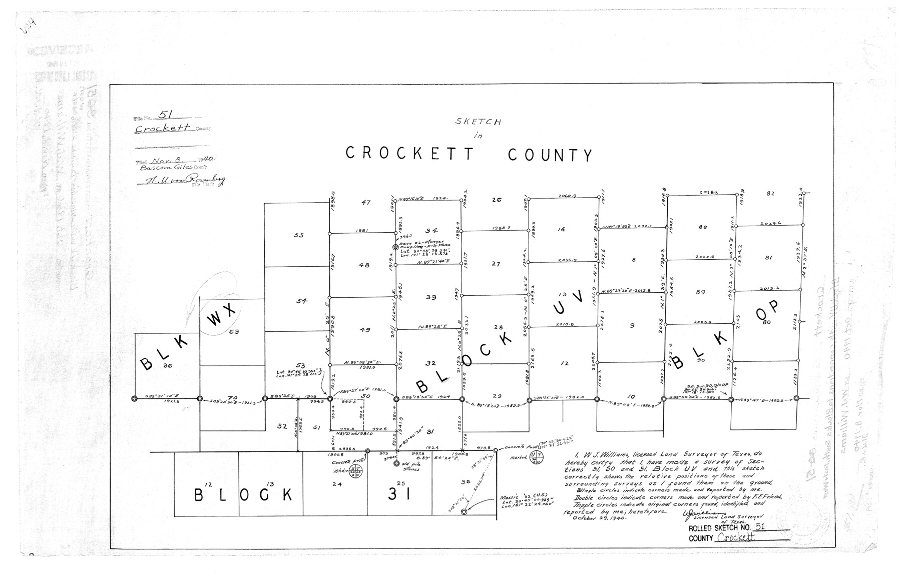
Crockett County Rolled Sketch 51
Sketch in Crockett County
-
Map/Doc
5597
-
Collection
General Map Collection
-
Object Dates
1940/10/29 (Creation Date)
1940/11/8 (File Date)
-
People and Organizations
W.J. Williams (Surveyor/Engineer)
-
Counties
Crockett
-
Subjects
Surveying Rolled Sketch
-
Height x Width
17.1 x 26.6 inches
43.4 x 67.6 cm
Part of: General Map Collection
Lampasas County Working Sketch 1

Print $20.00
- Digital $50.00
Lampasas County Working Sketch 1
Size 16.2 x 20.3 inches
Map/Doc 70278
San Saba County Working Sketch 4

Print $20.00
- Digital $50.00
San Saba County Working Sketch 4
1941
Size 43.4 x 31.8 inches
Map/Doc 63792
Terrell County Working Sketch 3a

Print $20.00
- Digital $50.00
Terrell County Working Sketch 3a
1912
Size 26.1 x 21.2 inches
Map/Doc 62152
Gaines County Boundary File 4

Print $4.00
- Digital $50.00
Gaines County Boundary File 4
Size 14.4 x 8.9 inches
Map/Doc 53656
Winkler County Rolled Sketch 4

Print $40.00
- Digital $50.00
Winkler County Rolled Sketch 4
1927
Size 59.1 x 39.5 inches
Map/Doc 10147
Intracoastal Waterway in Texas - Corpus Christi to Point Isabel including Arroyo Colorado to Mo. Pac. R.R. Bridge Near Harlingen

Print $20.00
- Digital $50.00
Intracoastal Waterway in Texas - Corpus Christi to Point Isabel including Arroyo Colorado to Mo. Pac. R.R. Bridge Near Harlingen
1933
Size 27.9 x 40.8 inches
Map/Doc 61866
Wise County Sketch File 48

Print $10.00
- Digital $50.00
Wise County Sketch File 48
1922
Size 14.2 x 8.7 inches
Map/Doc 40613
Harrison County

Print $20.00
- Digital $50.00
Harrison County
1920
Size 47.7 x 42.9 inches
Map/Doc 4972
Cooke County Working Sketch 8

Print $20.00
- Digital $50.00
Cooke County Working Sketch 8
1940
Size 41.5 x 28.1 inches
Map/Doc 68245
Map of Lavaca County

Print $20.00
- Digital $50.00
Map of Lavaca County
1866
Size 22.3 x 23.7 inches
Map/Doc 3802
Maps of Gulf Intracoastal Waterway, Texas - Sabine River to the Rio Grande and connecting waterways including ship channels

Print $20.00
- Digital $50.00
Maps of Gulf Intracoastal Waterway, Texas - Sabine River to the Rio Grande and connecting waterways including ship channels
1966
Size 14.5 x 22.2 inches
Map/Doc 61919
Bosque County Rolled Sketch 3

Print $20.00
- Digital $50.00
Bosque County Rolled Sketch 3
Size 24.6 x 19.1 inches
Map/Doc 89015
You may also like
Refugio County NRC Article 33.136 Sketch 4

Print $46.00
- Digital $50.00
Refugio County NRC Article 33.136 Sketch 4
2014
Size 18.0 x 24.0 inches
Map/Doc 94491
Outer Continental Shelf Leasing Maps (Texas Offshore Operations)

Print $20.00
- Digital $50.00
Outer Continental Shelf Leasing Maps (Texas Offshore Operations)
Size 17.3 x 16.7 inches
Map/Doc 75841
Yates Pool, Pecos County, Texas

Print $20.00
- Digital $50.00
Yates Pool, Pecos County, Texas
1928
Size 21.3 x 18.3 inches
Map/Doc 91623
Flight Mission No. DQO-8K, Frame 46, Galveston County

Print $20.00
- Digital $50.00
Flight Mission No. DQO-8K, Frame 46, Galveston County
1952
Size 18.7 x 22.4 inches
Map/Doc 85153
Val Verde County Sketch File 53

Print $20.00
- Digital $50.00
Val Verde County Sketch File 53
1892
Size 45.0 x 16.2 inches
Map/Doc 10421

Corpus Christi Bay

Print $20.00
- Digital $50.00
Corpus Christi Bay
1973
Size 36.6 x 47.7 inches
Map/Doc 73474
Burnet County Working Sketch 8

Print $20.00
- Digital $50.00
Burnet County Working Sketch 8
1973
Size 27.2 x 28.0 inches
Map/Doc 67851
Medina County Rolled Sketch 23

Print $20.00
- Digital $50.00
Medina County Rolled Sketch 23
Size 30.4 x 42.6 inches
Map/Doc 89063
Winkler County Working Sketch 6

Print $20.00
- Digital $50.00
Winkler County Working Sketch 6
1957
Size 34.5 x 31.5 inches
Map/Doc 72600
Military Map of the Rio Grande Frontier Prepared from Original Surveys, County Maps, Reports of Officers, etc

Print $20.00
Military Map of the Rio Grande Frontier Prepared from Original Surveys, County Maps, Reports of Officers, etc
1883
Size 17.4 x 27.3 inches
Map/Doc 76242
[Surveys between Upper Keechi Creek and the Trinity River]
![293, [Surveys between Upper Keechi Creek and the Trinity River], General Map Collection](https://historictexasmaps.com/wmedia_w700/maps/293.tif.jpg)
Print $2.00
- Digital $50.00
[Surveys between Upper Keechi Creek and the Trinity River]
Size 8.5 x 6.9 inches
Map/Doc 293