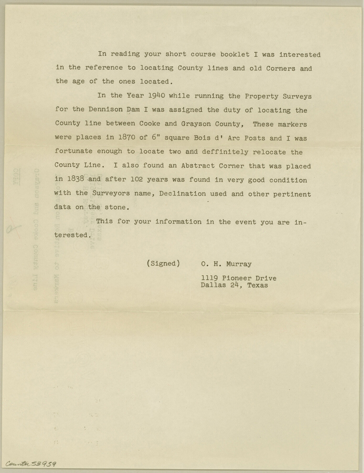
Grayson County Boundary File 5
Grayson & Cooke County Line Information Relative to Markers
- 
                          Map/Doc
53959
 - 
                            Collection
General Map Collection
 - 
                            Counties
Grayson
 - 
                            Subjects
County Boundaries
 - 
                            Height x Width
11.2 x 8.7 inches
28.4 x 22.1 cm
 
Part of: General Map Collection
            Real County Working Sketch 19


                                            Print $3.00                    
                                             -                         Digital $50.00                                    
                Real County Working Sketch 19
1944
Size 12.0 x 10.4 inches
                                Map/Doc 71911
            
            Hidalgo County Sketch File 2


                                            Print $14.00                    
                                             -                         Digital $50.00                                    
                Hidalgo County Sketch File 2
1877
Size 10.1 x 8.1 inches
                                Map/Doc 26394
            
            Sterling County Sketch File 25


                                            Print $4.00                    
                                             -                         Digital $50.00                                    
                Sterling County Sketch File 25
1892
Size 11.1 x 8.9 inches
                                Map/Doc 37192
            
            Flight Mission No. CUG-2P, Frame 81, Kleberg County


                                            Print $20.00                    
                                             -                         Digital $50.00                                    
                Flight Mission No. CUG-2P, Frame 81, Kleberg County
1956
Size 18.7 x 22.2 inches
                                Map/Doc 86213
            
            Dimmit County


                                            Print $40.00                    
                                             -                         Digital $50.00                                    
                Dimmit County
1976
Size 43.2 x 50.7 inches
                                Map/Doc 73133
            
            Flight Mission No. DAG-22K, Frame 74, Matagorda County


                                            Print $20.00                    
                                             -                         Digital $50.00                                    
                Flight Mission No. DAG-22K, Frame 74, Matagorda County
1953
Size 18.8 x 22.5 inches
                                Map/Doc 86461
            
            St. Louis, Brownsville & Mexico Railway Location Map from Mile 80 to Mile 100


                                            Print $40.00                    
                                             -                         Digital $50.00                                    
                St. Louis, Brownsville & Mexico Railway Location Map from Mile 80 to Mile 100
1905
Size 19.4 x 60.9 inches
                                Map/Doc 64165
            
            Sabine River, Merrill Lake Sheet


                                            Print $20.00                    
                                             -                         Digital $50.00                                    
                Sabine River, Merrill Lake Sheet
1933
Size 26.4 x 43.6 inches
                                Map/Doc 65137
            
            Pecos County Rolled Sketch 56


                                            Print $20.00                    
                                             -                         Digital $50.00                                    
                Pecos County Rolled Sketch 56
1916
Size 18.1 x 24.2 inches
                                Map/Doc 5229
            
            [Bastrop District]


                                            Print $20.00                    
                                             -                         Digital $50.00                                    
                [Bastrop District]
1838
Size 26.5 x 44.2 inches
                                Map/Doc 83519
            
            San Patricio County NRC Article 33.136 Sketch 8


                                            Print $26.00                    
                                             -                         Digital $50.00                                    
                San Patricio County NRC Article 33.136 Sketch 8
2018
Size 11.0 x 17.0 inches
                                Map/Doc 95341
            
            Flight Mission No. DQN-6K, Frame 69, Calhoun County


                                            Print $20.00                    
                                             -                         Digital $50.00                                    
                Flight Mission No. DQN-6K, Frame 69, Calhoun County
1953
Size 18.6 x 22.1 inches
                                Map/Doc 84441
            You may also like
            Wise County Sketch File 41


                                            Print $4.00                    
                                             -                         Digital $50.00                                    
                Wise County Sketch File 41
1875
Size 12.8 x 8.1 inches
                                Map/Doc 40599
            
            Nueces Bay and Adjoining Areas showing submerged Lands


                                            Print $40.00                    
                                             -                         Digital $50.00                                    
                Nueces Bay and Adjoining Areas showing submerged Lands
1946
Size 34.6 x 56.4 inches
                                Map/Doc 1916
            
            Right of Way Map, Belton Branch of the M.K.&T. RR.


                                            Print $20.00                    
                                             -                         Digital $50.00                                    
                Right of Way Map, Belton Branch of the M.K.&T. RR.
1896
Size 14.5 x 42.1 inches
                                Map/Doc 64219
            
            The Rand McNally New Commercial Atlas Map of Texas


                                            Print $20.00                    
                                             -                         Digital $50.00                                    
                The Rand McNally New Commercial Atlas Map of Texas
1914
Size 28.6 x 40.2 inches
                                Map/Doc 95849
            
            Flight Mission No. CRC-3R, Frame 28, Chambers County


                                            Print $20.00                    
                                             -                         Digital $50.00                                    
                Flight Mission No. CRC-3R, Frame 28, Chambers County
1956
Size 18.8 x 22.4 inches
                                Map/Doc 84803
            
            Nueces County Sketch File 77a and 77b


                                            Print $26.00                    
                                             -                         Digital $50.00                                    
                Nueces County Sketch File 77a and 77b
1986
Size 11.1 x 8.6 inches
                                Map/Doc 33057
            
            Map of Eastland Co.


                                            Print $20.00                    
                                             -                         Digital $50.00                                    
                Map of Eastland Co.
1896
Size 40.8 x 43.8 inches
                                Map/Doc 66809
            
            Current Miscellaneous File 102


                                            Print $611.00                    
                                             -                         Digital $50.00                                    
                Current Miscellaneous File 102
Size 11.5 x 7.1 inches
                                Map/Doc 74379
            
            Williamson County Sketch File 6


                                            Print $4.00                    
                                             -                         Digital $50.00                                    
                Williamson County Sketch File 6
1848
Size 12.8 x 8.1 inches
                                Map/Doc 40314
            
            Grayson County Sketch File 3a


                                            Print $20.00                    
                                             -                         Digital $50.00                                    
                Grayson County Sketch File 3a
1855
Size 19.6 x 25.5 inches
                                Map/Doc 11580
            
            Lampasas County Rolled Sketch 2


                                            Print $20.00                    
                                             -                         Digital $50.00                                    
                Lampasas County Rolled Sketch 2
Size 21.0 x 39.2 inches
                                Map/Doc 6565
            
            Tom Green County Rolled Sketch 5


                                            Print $20.00                    
                                             -                         Digital $50.00                                    
                Tom Green County Rolled Sketch 5
1947
Size 44.9 x 35.0 inches
                                Map/Doc 9997